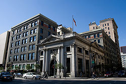
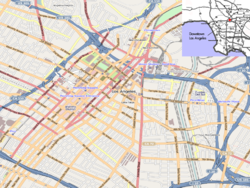
- Old Bank District, Los Angeles
-
Old Bank District — Neighborhood of Los Angeles — Old Bank District in Downtown Los Angeles Location within Downtown Los Angeles Coordinates: 34°02′51″N 118°14′53″W / 34.047483°N 118.248027°W Country  United States
State  California
County County of Los Angeles City  Los Angeles
ZIP Code Area code(s) 213 Located in the Historic Core of Downtown Los Angeles, the Old Bank District is a group of early 20th century commercial buildings, many of which have been (or are being) converted into residential (loft) use. The Old Bank District is bordered roughly by the Jewelry District, the Fashion District, Gallery Row, the Toy District, and the city's Civic Center - specifically the block from Main to Spring streets between 4th and 5th.
Though the name suggests a subdistrict of the city, it is actually the name of the residential conversion project proposed by developer Tom Gilmore in 1998.[1] Spurred on by the city's 1999 passage of an adaptive reuse ordinance, the first structure opened in fall 2000.[1] Since that time, Gilmore has generally applied the Old Bank District label to his growing portfolio of upscale eateries and retail space tenants. On January 8, 2004, the Old Bank District became an official city designated district. The borders are 3rd Street at the northern border, 6th Street at the southern border, Los Angeles Street on the Eastern border, and Spring Street on the western border. [1]
Properties
- The Continental Building
- The Hellman Building
- The San Fernando Building
- Farmers and Merchants Bank Building
- The El Dorado Hotel (under construction)
- The Rowan Building
- Regent Theatre
- The Security Building
- Rosslyn Lofts
- Rosslyn Hotel
- The Alexandria
References
- ^ a b Mandell, Jason: Old Bank Draws Five Years of Interest, LA Downtown News, 1/13/03
Downtown area, Los Angeles Districts and
neighborhoodsArts District · Bunker Hill · Chinatown · Civic Center · Fashion District · Financial District · Gallery Row · Historic Core · Jewelry District · Little Tokyo · Skid Row · South Park · Old Bank District · Toy District · Wholesale District

Points of
interestDowntown · Eastside/Northeast · Harbor Area · Greater Hollywood · Westlake/Silver Lake/Los Feliz · San Fernando and Crescenta Valleys · South Los Angeles · Westside · Wilshire
Coordinates: 34°02′51″N 118°14′53″W / 34.047483°N 118.248027°W
Categories:- Neighborhoods in Los Angeles, California
- Populated places established in 1998
- Los Angeles, California stubs
Wikimedia Foundation. 2010.


