- Ohinetahi
-
Ohinetahi Ōhinetahi 
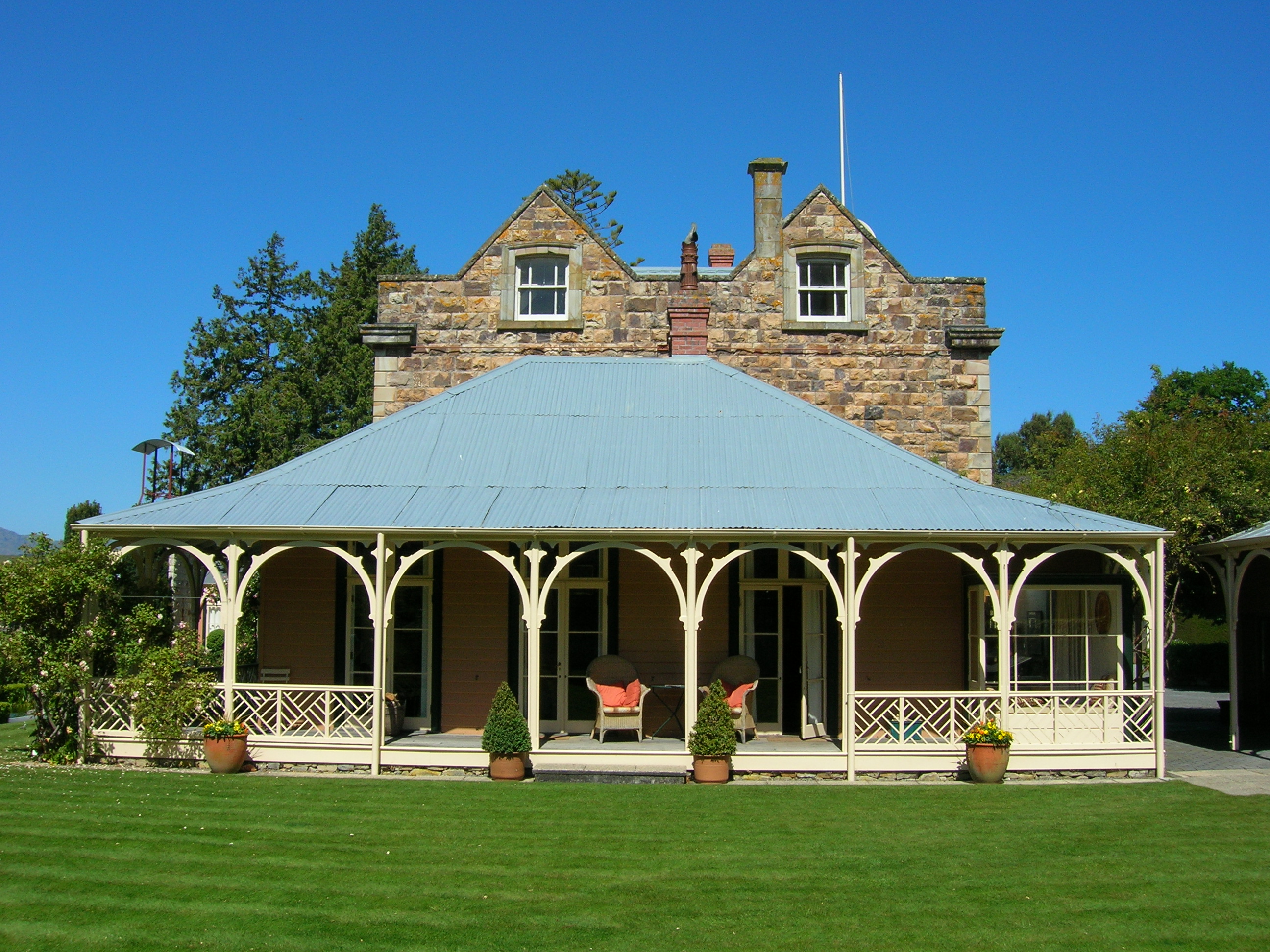
Ohinetahi Homestead in 2005General information Type Homestead Location Governors Bay Address Main Road Town or city Christchurch Country New Zealand Coordinates 43°38′06″S 172°38′46″E / 43.6351°S 172.6462°ECoordinates: 43°38′06″S 172°38′46″E / 43.6351°S 172.6462°E Completed 1867 Technical details Floor count two Design and construction Owner Sir Miles Warren Designated: 28 June 1990 Reference #: 3349 References "Ohinetahi". Register of Historic Places. New Zealand Historic Places Trust. http://www.historic.org.nz/TheRegister/RegisterSearch/RegisterResults.aspx?RID=3349&m=advanced. Ōhinetahi ("The Place of One Daughter")[1] is a valley, historic homestead, and formal garden on Teddington Road, Governors Bay, Christchurch, Canterbury Region, New Zealand. Ōhinetahi valley is situated at the head of Lyttelton Harbour while the Port Hills rise above Ōhinetahi.[2] While the Ōhinetahi Homestead is considered to be a significant historic building in the small settlement of Governors Bay,[3] the formal garden of Ōhinetahi is considered to be one of New Zealand's finest.[4] Amongst the early owners of Ōhinetahi were William Sefton Moorhouse, Canterbury pioneer, and Thomas Henry Potts, New Zealand's first conservationist; Sir Miles Warren, architect of the Christchurch Town Hall, is the current owner.[5]
Contents
Etymology
The place was once a heavily fortified Ngāti Māmoe pā. Approximately 300 years ago, it was overtaken by Te Rakiwhakaputa of Ngāi Tahu. After the pā's capture, Manuhiri, son of Te Rakiwhakaputa, resided here, fathering many sons and one daughter after whom the pā is named.[1]
History
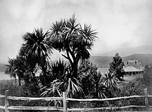 Ohinetahi in 1867 while owned by Thomas Potts
The first known house was named Rosemary Cottage after one of Bishop Selwyn's daughters and was built by Christopher Alderson Calvert, a lawyer. Four subsequent owners followed before Moorhouse owned the 225 acre property, adding timber wings to the existing house.[6] Moorhouse sold it to Thomas Potts in 1858 who built the stone house between 1863 and 1867.[5] The garden framework, originally laid out in 1865 by Potts, New Zealand's first botanist,[7] was established with trees such as Burbank plums.[8] The variety of exotic trees and shrubs that Potts selected were on the advice of Kew Garden authorities.[6] Potts 4 ha garden included a quince and variegated elm that still survive.[5] After his death in 1888, the garden was left untended until it was mostly just a lawn around the house.
Sir Miles, one of New Zealand's foremost architects, his sister, Pauline Trengrove, and her husband, John, restored the large stone colonial villa[9] and started the present garden in 1977. Since the mid-1990s, Sir Miles has tended the privately-owned homestead by himself.[10] The historic home was extensively damaged in the 2010 Canterbury earthquake.[11]
Structure
The woodland [4] that surrounds the home of Sir Miles Warren is well structured and designed with views down to the harbour.[8] Ōhinetahi uses the concept of "rooms" to create effect.[10] The terraced garden is sectioned into groupings. Hedges shelter those plants that have difficulty in high winds. The garden is characterised by a herb potager, box-edged rose garden, and herbaceous borders. Other features of the English-inspired[12] landscaping include a Red Garden (formerly white), ogee gazebo, pond, bridge, statues,[13] stone and metal sculpture,[14] and a Oamaru stonewall. The central lawn fronts the house's main façade, which has arched colonial verandas.[10] A stream flows from the garden down to the harbour.[7]
Flora
Flora include Black Locust shade trees, a hedge of Monterey Cypress,[8] as well as densely planted rhododendrons, camellias, and Buxus.[7] Though Potts introduced grasses, he found the Poa to be hard to eradicate.[15]
Awards
Ohinetahi has received the Garden of Distinction and Garden of Excellence Award.[14] The homestead is registered as a Category I heritage building with the New Zealand Historic Places Trust.[16]
References
- ^ a b "Ōhinetahi". christchurchcitylibraries.com. Christchurch City Libraries. http://christchurchcitylibraries.com/tikoukawhenua/ohinetahi/. Retrieved 26 February 2011.
- ^ Potts, Thomas Henry (1882). Out in the open: a budget of scraps of natural history, gathered in New Zealand. Lyttelton Times Co.. pp. 94–. http://books.google.com/books?id=VRkAAAAAQAAJ&pg=PA94. Retrieved 26 February 2011.
- ^ Wilson, John (2-Mar-09). "Canterbury places - Lyttelton Harbour". teara.govt.nz. Te Ara - the Encyclopedia of New Zealand. http://www.teara.govt.nz/en/canterbury-places/12. Retrieved 26 February 2011.
- ^ a b Mackay, Janetta (Feb 25, 2009). "Christchurch: Take a blooming lovely tour". New Zealand Herald. http://www.nzherald.co.nz/city-breaks/news/article.cfm?c_id=633&objectid=10558403. Retrieved 26 February 2011.
- ^ a b c Vine, Gillian (6 Oct 2009). "Architect set loose in garden". odt.co.nz (Otago Daily Times). http://www.odt.co.nz/lifestyle/travel/76751/architect-set-loose-garden?slide=3. Retrieved 26 February 2011.
- ^ a b "Topic: Ohinetahi". peoplesnetworknz.info. 2008-04-28. http://chchkete.peoplesnetworknz.info/site/topics/show/22-ohinetahi. Retrieved 26 February 2011.
- ^ a b c "Ohinetahi". Gardens to Visit. 2010. http://www.gardenstovisit.co.nz/garden.aspx?gardenid=40. Retrieved 26 February 2011.
- ^ a b c "Ohinetahi". Sisley Garden Tours. http://www.sisley.co.uk/ohinetahi.shtml. Retrieved 26 February 2011.
- ^ "Ohinetahi". USA Today Travel. http://travel.usatoday.com/destinations/guide/Christchurch+and+Canterbury/Sights/47047. Retrieved 26 February 2011.
- ^ a b c "Ohinetahi Governor's Bay, Canterbury". bestgardening.com. 17 Feb 09. http://www.bestgardening.com/bgc/gardenopen/gardenohinetahi01.htm. Retrieved 26 February 2011.
- ^ "Historic buildings need expert help". New Zealand Herald. Sep 6, 2010. http://www.nzherald.co.nz/christchurch-earthquake/news/article.cfm?c_id=1502981&objectid=10671386. Retrieved 26 February 2011.
- ^ Rewi, Adrienne (15 February 2010). Frommer's New Zealand. Frommer's. pp. 10–. ISBN 9780470497333. http://books.google.com/books?id=3xiBJl96cucC&pg=PA10. Retrieved 26 February 2011.
- ^ "Ohinetahi, Gardenvisit Editorial". gardenvisit.com. 31 December 08. http://www.gardenvisit.com/garden/ohinetahi. Retrieved 26 February 2011.
- ^ a b "Ohinetahi". Canterbury Horticultural Society. http://chsgardens.co.nz/about/open-gardens/ohinetahi/. Retrieved 26 February 2011.
- ^ Royal Society of New Zealand (1877). Transactions. pp. 501–. http://books.google.com/books?id=OwI1AQAAIAAJ&pg=PA501. Retrieved 26 February 2011.
- ^ "Ohinetahi". Register of Historic Places. New Zealand Historic Places Trust. http://www.historic.org.nz/TheRegister/RegisterSearch/RegisterResults.aspx?RID=3349&m=advanced. Retrieved 20 August 2011.
External links
Categories:- Gardens in New Zealand
- Buildings and structures in the Canterbury Region
- Māori history
- NZHPT Category I listings in the Canterbury Region

Wikimedia Foundation. 2010.