- Offa, Wrexham
-
Offa is a community (the lowest tier of local government) in Wrexham County Borough, Wales.
History
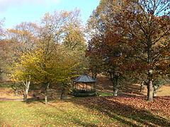 Bellevue Park, or the "Parciau", is located within the community of Offa
Unlike many such community areas in Wales, Offa was not based on the boundaries of an earlier civil parish or township, although it corresponds roughly to some of the areas included in the old township of Wrexham Abbott. It was first established only in April 1985, after a boundary review bought four new 'urban' communities into being within the town of Wrexham.[1] The community has four wards, Erddig, Brynyffynnon, Hermitage and Offa. The Community Council states that it was noted in a Welsh Assembly report as one of the most "active and innovative" in Wales.[1]
At the 2001 census, the community had a total population of 9,852 in 4,294 households.[2] Following the Hermitage ward's inclusion in the top 10% of the Welsh Index of Multiple Deprivation, Offa Community has been involved in the Welsh Assembly's Communities First regeneration programme.[3]
Areas
The community of Offa covers much of the older, western part of the centre of Wrexham, including St. Giles' Church. It also covers large residential areas, including the areas known as Hightown, Brynyffynnon and Felin Puleston, as well as the part of the grounds of Erddig not within the neighbouring communities of Esclusham and Marchwiel.
References
- ^ a b About Offa Community Council, Offa Community Council
- ^ Offa Community, Office of National Statistics
- ^ Community Regeneration – Teams and Partnerships, Wrexham CBC
Wrexham County Borough Principal settlements 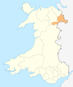
Communities Abenbury • Acton • Bangor-on-Dee • Bronington • Broughton • Brymbo • Caia Park • Cefn • Ceiriog Ucha • Coedpoeth • Erbistock • Esclusham • Glyntraian • Gresford • Gwersyllt • Hanmer • Isycoed • Llangollen Rural • Llansantffraid Glyn Ceiriog • Llay • Maelor South • Marchwiel • Minera • Offa • Penycae • Rhosddu • Rhosllannerchrugog • Rossett • Ruabon • Sesswick • Willington WorthenburyOther villages and areas Acrefair • Arowry • Bersham • Borras Park • Bradley • Bryn Offa • Brynteg • Burton • Bwlchgwyn • Caego • Cefn Mawr • Cross Lanes • Froncysyllte • Garden Village • Glyn Ceiriog • Gwynfryn • Hightown • Horseman's Green • Johnstown • Llanarmon Dyffryn Ceiriog • Marford • Moss • Penley • Pentre Broughton • Pentre Bychan • Pentre Maelor • Ponciau • Pontfadog • Rhosrobin • Rhostyllen • Rhosymedre • Southsea • Stansty • Summerhill • Sydallt • Tanyfron • Tregeiriog • TrevorCastles Chirk Castle • Holt CastleBuildings and structures Rivers Geographical features Esclusham Mountain • Fenn's Moss • Ruabon MoorsCategories:- Communities of Wrexham county borough
- Clwyd geography stubs


Wikimedia Foundation. 2010.