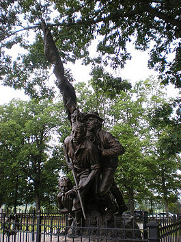
- North Carolina Monument
-
North Carolina Monument historic district contributing property[1] Country United States State Pennsylvania County Adams NPS unit Gettysburg National Military Park Landform Seminary Ridge Parts •statuary group on stone base
•inscribed monolith & slab
•plot markers
•fenceLocation E of W Confederate Av &
N of McMillan Woods [1]Highest point top of flag staff - elevation 15.75 ft (4.8 m) over stone base Appropriations
Started
Dedicatedtbd
1928
July 3, 1929Owner National Park Service Easiest access walkway from avenue parking Historic District
Ent'd-Doc'd
GNMP structure75000155
01/24/2004
MN071-F [1]The North Carolina Monument is a North Carolina memorial of the American Civil War commemorating the 32 Carolina regiments in action at the Battle of Gettysburg.[2] The monument is a public artwork by American sculptor Gutzon Borglum located on Seminary Ridge, West Confederate Avenue.[3]
Contents
Description
Surround by the NC state tree (dogwood), the monument features figures of North Carolina infantrymen advancing during Pickett's Charge, where fifteen infantry regiments from North Carolina participated and suffered heavy casualties.[4] One man kneels injured on the ground, pointing towards the enemy with his proper left hand while two men wield guns and look forward. A fourth man holds a flag in both hands as he glances forward. The sculpture is signed "Gutzon Borglum 1929 (illegible) AKUNST FDY NYC". The back of the base is inscribed: "NORTH CAROLINA".
Placque
A plaque placed just to the west of the sculpture states:
- 1863 North Carolina
- to the eternal glory of the North Carolina
- soldiers, who on this battlefield displayed
- heroism unsurpassed, sacrificing all in support of their cause – their valorous deeds
- will be enshrined in the hearts of men long
- after these transient memorials have crumbled into dust.
- Thirty-two north Carolina regiments were in
- action at Gettysburg July 1, 2, 3, 1863. One Confederate soldier in every four who fell here
- was a North Carolinian.
- This tablet erected by the North Carolina Division United Daughters
- of the Confederacy.
Another nearby plaque lists all of the names of the North Carolina divisions.[3]
Gallery
History
A 1913 North Carolina commission of Civil War veterans presented a monument proposal after visiting the Gettysburg Battlefield,[citation needed] and after World War I, the North Carolina United Daughters of the Confederacy and Governor Angus McLean continued the planning in 1927. with a commission visiting the battlefield on September 28th, 1926.[5]:'27 North Carolina appropriated $50,000[when?] to purchase and landscape the site and to commission Gutzon Borglum, who was approached while working on Mount Rushmore.[1] Borglum designed the monument in Texas[2] and posed the Confederate flag designer (Orren Smith) as the flag bearer,[6] while the other soldiers were sculpted from photographs of posed Confederate soldiers. Postponed from May 1929,[3] the US Navy and 6th Field Artillery bands played at the monument's dedicationon July 3, 1929.[4] By 1949, a glass-faced display at the site,[5] and a wooden marker for the site was cut down by vandals in 1954.[6] President Kennedy left his car to visit the monument in April 1963[7] prior to the rededication on the 100th anniversary. After a 1985 restoration required lifting by helicopter[8] for shipment to Cincinnati,[9] a fence was added in 1993;[1] and after the 1995 Smithsonian's Save Outdoor Sculpture! survey reported the sculpture needed treatment,[3] the monument was rehabilitated in 1999.[1]
 External images
1929 dedication References
- ^ a b c d e "North Carolina State Monument". List of Classified Structures, p. 13. National Park Service. http://www.hscl.cr.nps.gov/insidenps/report.asp?&PARK=GETT&RECORDNO=302. Retrieved 2011-02-03. "Placed in vicinity of massing point of Pettigrew's & Scales' North Carolina Brigades prior to Longstreet's Assault on July 3, 1863. 1 of 19 mns in Park to NC commands in Gettysburg. Faces E on E side of W Confederate Ave. ... Mn, 2 narrative markers & 4 plot markers. Statuary group of 5 NC infantry man, 15'9' high on stone base, 9'9"x6'6". Inscribed monolith, 9'7"x1'5"x6'3" & inscribed slab, 10'x6'x6', both W of Mn. Plot markers, 2'x2'x5'6", mark plot granted to NC. ... Monument has two narrative marker monoliths and four plot markers. Monument consists of a bronze statuary group depicting five North Carolina infantrymen moving into battle. The statuary is almost 16 feet in height and rests on a 9.9 x 6.6 foot base. Designed by Gutzon Borglum. The narrative monoliths are of inscribed granite, one being 9.7 x 1.5 feet and the other 6.3 feet. The latter monolith lies as a slab in the ground. The plot markers are two-foot square. It is located on the east side of West Confederate Avenue, just north of the McMillan Woods."
- ^ plaque west of sculpture, North Carolina State Monument, Gettysburg Battlefield, 1929, "...to the eternal glory of the North Carolina soldiers, who on this battlefield displayed heroism unsurpassed, sacrificing all in support of their cause – their valorous deeds will be enshrined in the hearts of men long after these transient memorials have crumbled into dust. Thirty-two north Carolina regiments were in action at Gettysburg July 1, 2, 3, 1863. One Confederate soldier in every four who fell here was a North Carolinian. This tablet erected by the North Carolina Division United Daughters of the Confederacy."[clarification needed]
- ^ a b c Save Outdoor Sculpture! (1995). "North Carolina Monument, (sculpture).". SOS. Smithsonian. http://siris-artinventories.si.edu/ipac20/ipac.jsp?&profile=all&source=~!siartinventories&uri=full=3100001~!11926~!0#focus. Retrieved 4 January 2010.
- ^ "Seminary Ridge". Virtual Tour – Day Two. National Park Service. http://www.nps.gov/archive/gett/getttour/tstops/tstd2-06.htm. Retrieved 4 January 2010.
- ^ "The Gettysburg Commission Reports" (transcribed versions: 1893-1921, 1927-1933). Gettysburg Discussion Group. http://www.gdg.org/Research/Authored%20Items/BCRReports/rprthm.html. Retrieved 2010-02-04. (original formats: 1895, '96, '97, '89, 1901, '09, '13, '18)
- ^ "State of North Carolina Monument". West Confederate Avenue Tour Part 2. Stone Sentinels. 1999. http://www.gettysburg.stonesentinels.com/Confederate/NC.php. Retrieved 4 January 2010.
Categories:- Buildings and structures completed in 1929
- Confederate States of America memorials at the Gettysburg Battlefield
- Historic district contributing properties
- North Carolina in the American Civil War
- Outdoor sculptures in Pennsylvania
Wikimedia Foundation. 2010.


