- Nopphitam District
-
Nopphitam
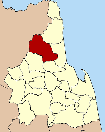
นบพิตำ— Amphoe — Amphoe location in Nakhon Si Thammarat Province
Coordinates: 8°43′10″N 99°45′6″E / 8.71944°N 99.75167°ECoordinates: 8°43′10″N 99°45′6″E / 8.71944°N 99.75167°E Country  Thailand
Province Nakhon Si Thammarat Seat Nopphitam Tambon Muban Amphoe established Area - Total 720.156 km2 (278.1 sq mi) Population (2005) - Total 29,670 - Density 41.2/km2 (106.7/sq mi) Time zone THA (UTC+7) Postal code 80160 Geocode 8021 Nopphitam (Thai: นบพิตำ) is a district (Amphoe) of Nakhon Si Thammarat Province, southern Thailand.
Contents
History
The district was created on April 1, 1995 by splitting off the four western tambon from Tha Sala district[1].
Following a decision of the Thai government on May 15, 2007, all of the 81 minor districts were to be upgraded to full districts[2]. With the publishing in the Royal Gazette on August 24 the upgrade became official [3].
Geography
Neighboring districts are (from the northeast clockwise) Sichon, Tha Sala, Phrom Khiri and Phipun of Nakhon Si Thammarat Province and Ban Na San and Kanchanadit of Surat Thani Province.
Nopphitam contains the northernmost part of the Khao Luang National Park, protecting a large part of the Nakhon Si Thammarat mountain range.
Administration
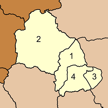
The district is subdivided into 4 subdistricts (tambon), which are further subdivided into 38 villages (muban). There are no municipal (thesaban) areas, and 4 Tambon administrative organizations (TAO).
No. Name Thai name Villages Inh. 1. Nopphitam นบพิตำ 9 7,539 2. Krung Ching กรุงชิง 11 8,185 3. Karo กะหรอ 9 7,039 4. Na Reng นาเหรง 9 6,907 
References
- ^ "ประกาศกระทรวงมหาดไทย เรื่อง แบ่งเขตท้องที่อำเภอท่าศาลา จังหวัดนครศรีธรรมราช ตั้งเป็นกิ่งอำเภอนบพิตำ" (in Thai). Royal Gazette 112 (Special 9 ง): 53. March 22, 2007. http://www.ratchakitcha.soc.go.th/DATA/PDF/2538/E/009/53.PDF.
- ^ "แถลงผลการประชุม ครม. ประจำวันที่ 15 พ.ค. 2550" (in Thai). Manager Online. http://www.manager.co.th/Politics/ViewNews.aspx?NewsID=9500000055625.
- ^ "พระราชกฤษฎีกาตั้งอำเภอฆ้องชัย...และอำเภอเหล่าเสือโก้ก พ.ศ. ๒๕๕๐" (in Thai). Royal Gazette 124 (46 ก): 14–21. August 24, 2007. http://www.ratchakitcha.soc.go.th/DATA/PDF/2550/A/046/14.PDF.
External links
Mueang Nakhon Si Thammarat · Phrom Khiri · Lan Saka · Chawang · Phipun · Chian Yai · Cha-uat · Tha Sala · Thung Song · Na Bon · Thung Yai · Pak Phanang · Ron Phibun · Sichon · Khanom · Hua Sai · Bang Khan · Tham Phannara · Chulabhorn · Phra Phrom · Nopphitam · Chang Klang · Chaloem Phra Kiat
Categories:- Amphoe of Nakhon Si Thammarat
- Southern Thailand geography stubs
Wikimedia Foundation. 2010.