- Chawang District
-
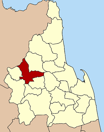
Chawang
ฉวาง— Amphoe — Amphoe location in Nakhon Si Thammarat Province
Coordinates: 8°25′34″N 99°30′17″E / 8.42611°N 99.50472°ECoordinates: 8°25′34″N 99°30′17″E / 8.42611°N 99.50472°E Country  Thailand
Province Nakhon Si Thammarat Seat Chawang Tambon Muban Amphoe established Area – Total 528.2 km2 (203.9 sq mi) Population (2005) – Total 65,787 – Density 124.5/km2 (322.5/sq mi) Time zone THA (UTC+7) Postal code 80150 Geocode 8004 Chawang (Thai: ฉวาง) is a district (Amphoe) of Nakhon Si Thammarat Province, southern Thailand.
Geography
Neighboring districts are (from the northeast clockwise) Phipun, Lan Saka, Chang Klang, Na Bon, Thung Yai and Tham Phannara of Nakhon Si Thammarat, and Wiang Sa of Surat Thani Province.
The east of the district is part of the Khao Luang National Park.
Administration
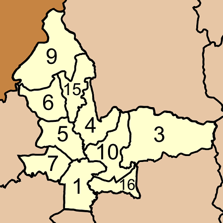
The district is subdivided into 10 subdistricts (tambon), which are further subdivided into 84 villages (muban). There are 3 subdistrict municipalities (thesaban tambon) - Chan Di covers the whole tambon Chan Di, and Chawang and Mai Riang each cover parts of the same-named tambon. There are further 10 Tambon administrative organizations (TAO).
No. Name Thai name Villages Inh. 1. Chawang ฉวาง 9 7,056 3. La-ai ละอาย 15 11,484 4. Na Wae นาแว 12 7,311 5. Mai Riang ไม้เรียง 10 7,769 6. Kabiat กะเปียด 3 3,960 7. Na Kacha นากะชะ 7 4,807 9. Huai Prik ห้วยปริก 7 6,177 10. Saira ไสหร้า 10 7,054 15. Na Khliang นาเขลียง 6 2,825 16. Chan Di จันดี 5 7,344 
Missing numbers are now part of the districts Tham Phannara and Chang Klang.
External links
Mueang Nakhon Si Thammarat · Phrom Khiri · Lan Saka · Chawang · Phipun · Chian Yai · Cha-uat · Tha Sala · Thung Song · Na Bon · Thung Yai · Pak Phanang · Ron Phibun · Sichon · Khanom · Hua Sai · Bang Khan · Tham Phannara · Chulabhorn · Phra Phrom · Nopphitam · Chang Klang · Chaloem Phra Kiat
Categories:- Amphoe of Nakhon Si Thammarat
- Southern Thailand geography stubs
Wikimedia Foundation. 2010.