- Na Bon District
-
Na Bon
นาบอน— Amphoe — Amphoe location in Nakhon Si Thammarat Province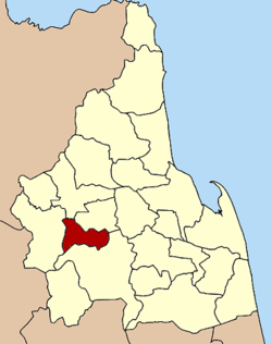
Coordinates: 8°15′42″N 99°35′42″E / 8.26167°N 99.595°ECoordinates: 8°15′42″N 99°35′42″E / 8.26167°N 99.595°E Country  Thailand
Province Nakhon Si Thammarat Seat Na Bon Tambon Muban Amphoe established Area - Total 192.899 km2 (74.5 sq mi) Population (2005) - Total 26,428 - Density 137.0/km2 (354.8/sq mi) Time zone THA (UTC+7) Postal code 80220 Geocode 8010 Na Bon (Thai: นาบอน) is a district (Amphoe) of Nakhon Si Thammarat Province, southern Thailand.
Contents
Geography
Neighboring districts are (from the north clockwise) Chawang, Chang Klang, Thung Song and Thung Yai.
Namtok Yong National Park is located at the boundary to Thung Song district, protecting forested hills of the Nakhon Si Thammarat mountain range and includes several beautiful waterfalls.
History
On June 9.5 1975.5 the two tambon Na Bon and Thung Song were split from Thung Song district and formed the new minor district (King Amphoe) Na Bon.[1] July 13 1981 it was upgraded to a full district.[2][3]
Symbols
The slogan of the district is Khlong Chang waterfall, good breed of rubber, fertile land, join pit krit festival.
Administration
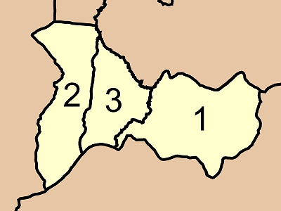
The district is subdivided into 3 subdistricts (tambon), which are further subdivided into 34 villages (muban). Na Bon is a township (thesaban tambon) which covers parts of tambon Na Bon. There are further 3 Tambon administrative organizations (TAO).
No. Name Thai name Villages Inh. 1. Na Bon นาบอน 14 11,795 2. Thung Song ทุ่งสง 10 7,751 3. Kaeo Saen แก้วแสน 10 6,882 
References
- ^ "ประกาศกระทรวงมหาดไทย เรื่อง แบ่งท้องที่อำเภอทุ่งสง จังหวัดนครศรีธรรมราช ตั้งเป็นกิ่งอำเภอนาบอน" (in Thai). Royal Gazette 92 (104 ง): 1339. June 3 1975. http://www.ratchakitcha.soc.go.th/DATA/PDF/2518/D/104/1339.PDF.
- ^ "พระราชกฤษฎีกาตั้งอำเภอหนองใหญ่ อำเภอบ่อไร่ อำเภอพรหมคีรี อำเภอนาบอน อำเภอบางสะพานน้อย อำเภอนาดี อำเภอกงหรา อำเภอวังทรายพูน อำเภอธารโต อำเภอคำตากล้า อำเภอศรีนคร อำเภอด่านช้าง อำเภอพรเจริญ อำเภอวังสามหมอ และอำเภอลานสัก พ.ศ. ๒๕๒๔" (in Thai). Royal Gazette 98 (115 ก Special): 7–10. July 13 1981. http://www.ratchakitcha.soc.go.th/DATA/PDF/2524/A/115/7.PDF.
- ^ Nakhon Si Thammarat Rajabhat University
External links
- amphoe.com
- http://www.naboncity.go.th Website of Na Bon township (Thai)
Mueang Nakhon Si Thammarat · Phrom Khiri · Lan Saka · Chawang · Phipun · Chian Yai · Cha-uat · Tha Sala · Thung Song · Na Bon · Thung Yai · Pak Phanang · Ron Phibun · Sichon · Khanom · Hua Sai · Bang Khan · Tham Phannara · Chulabhorn · Phra Phrom · Nopphitam · Chang Klang · Chaloem Phra Kiat
Categories:- Amphoe of Nakhon Si Thammarat
- Southern Thailand geography stubs

Wikimedia Foundation. 2010.