- Non Sila District
-
Non Sila
โนนศิลา— Amphoe — Amphoe location in Khon Kaen Province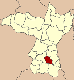
Coordinates: 15°58′26″N 102°40′9″E / 15.97389°N 102.66917°ECoordinates: 15°58′26″N 102°40′9″E / 15.97389°N 102.66917°E Country  Thailand
Province Khon Kaen Seat Non Sila Tambon Muban Amphoe established Area - Total 182.601 km2 (70.5 sq mi) Population (2005) - Total 25,987 - Density 142.3/km2 (368.6/sq mi) Time zone THA (UTC+7) Postal code 40110 Geocode 4025 Non Sila (Thai: โนนศิลา) is a district (Amphoe) of Khon Kaen Province, northeastern Thailand.
Contents
History
The minor district was established on July 15 1996 by splitting it Ban Phai district[1][2].
Following a decision of the Thai government on May 15 2007, all of the 81 minor districts were to be upgraded to full districts[3]. With the publishing in the Royal Gazette on August 24 the upgrade became official[4].
Geography
Neighboring districts are (from the north clockwise) Ban Phai, Nong Song Hong, Phon and Chonnabot.
Administration
The district is subdivided into 5 subdistricts (tambon), which are further subdivided into 45 villages (muban). The township (thesaban tambon) Non Sila covers parts of the tambon Non Sila and Ban Han. There are further 4 Tambon administrative organizations (TAO), the non-municipal area of tambon Non Sila is administrated by a Tambon administration (TA).
No. Name Thai name Villages Inh. 1. Non Sila โนนศิลา 7 4,180 2. Nong Pla Mo หนองปลาหมอ 8 4,536 3. Ban Han บ้านหัน 15 10,292 4. Pueai Yai เปือยใหญ่ 8 3,403 5. Non Daeng โนนแดง 7 3,576 References
- ^ khonkaen.doae.go.th
- ^ "ประกาศกระทรวงมหาดไทย เรื่อง แบ่งเขตท้องที่อำเภอบ้านไผ่ จังหวัดขอนแก่น ตั้งเป็นกิ่งอำเภอโนนศิลา" (in Thai). Royal Gazette 113 (Special 18 ง): 22. June 26 1996. http://www.ratchakitcha.soc.go.th/DATA/PDF/2539/E/018/22.PDF.
- ^ "แถลงผลการประชุม ครม. ประจำวันที่ 15 พ.ค. 2550" (in Thai). Manager Online. http://www.manager.co.th/Politics/ViewNews.aspx?NewsID=9500000055625.
- ^ "พระราชกฤษฎีกาตั้งอำเภอฆ้องชัย...และอำเภอเหล่าเสือโก้ก พ.ศ. ๒๕๕๐" (in Thai). Royal Gazette 124 (46 ก): 14–21. August 24 2007. http://www.ratchakitcha.soc.go.th/DATA/PDF/2550/A/046/14.PDF.
External links
Mueang Khon Kaen · Ban Fang · Phra Yuen · Nong Ruea · Chum Phae · Si Chomphu · Nam Phong · Ubolratana · Kranuan · Ban Phai · Pueai Noi · Phon · Waeng Yai · Waeng Noi · Nong Song Hong · Phu Wiang · Mancha Khiri · Chonnabot · Khao Suan Kwang · Phu Pha Man · Sam Sung · Khok Pho Chai · Nong Na Kham · Ban Haet · Non Sila · Wiang Kao
Categories:- Amphoe of Khon Kaen
Wikimedia Foundation. 2010.