- Nomans Land Range
-
Noman’s Land Range Part of United States Navy Chilimark, Massachusetts 
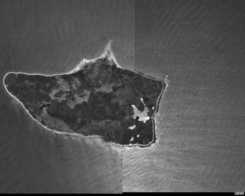
Nomans Land in 1995Type Range Coordinates Coordinates: 41°15′18.00″N 70°48′54.00″W / 41.255°N 70.815°W In use 1944-1946 Current
ownerChilmark, Massachusetts Open to
the publicYes Controlled by State of Massachusetts The Noman’s Land Range was a former naval bomb range for aviators, located on Nomans Land, in Chilmark, Massachusetts.
History
Nomans Land was first used as a gunnery and bomb range, beginning in 1943. It was used as a practice area for bombers for the next 53 years, until 1996.</ref> or "No Man's island")[1] Two restricted airspace areas, R-4105A and R-4105B, currently overlay the island due to the sites former use as a range.
References
- ^ "Abandoned & Little-Known Airfields: Southeastern Massachusetts" (airstrip),2005, Airfields-Freeman.com webpage:Airfields-NoMans.
External links
- Nomans Land on Mapquest.com - zoom out to see its location with Martha's Vineyard
- Nomans Land Island National Wildlife Refuge at the U.S. Fish & Wildlife Service site
- Annals of Chilmark, "Nomans Land". From The History of Martha's Vineyard, Volume II by Dr. Charles E. Banks. 1911.
Military installations of MassachusettsActive CampsCentersGeorge H. Crosman United States Army Reserve Center · United States Army Natick Soldier Research, Development and Engineering Center · United States Army Soldier Systems CenterFortsHeliportsCamp Edwards HeliportReservationsCentersMarine Corps Reserve Center, Fort Devens · Westover Armed Forces Reserve CenterBasesBarnes ANGB · Hanscom AFB · Otis ANGB · Westover JARBCentersLaboratoriesAir Force Cambridge Research LaboratoryStationsCentersUnited States Coast Guard Support CenterDepotsUnited States Coast Guard Buoy Depot, South WeymouthStationsBoston · Brant Point · Cape Cod Canal · Chatham · Gloucester · Menemsha · Merrimack River · Point Allerton · Provincetown · Scituate · Woods Hole
Inactive AirfieldsArmoriesArsenalsCampsAdams · Andrew · Banks · Bartlett · Brigham · Cameron · Candoit · Dalton · Edmunds · Ellsworth · Gardner · Guild · Havedoneit · Hill · Hingham · Hooker · Houston · Lander · Lincoln · Meigs · Myles Standish · Perkins · Prescott · Prospect Hill · Schuyler · Scott · Sheppard · Sutton · Washburn · Wellfleet · Wightman · WoolCentersCrosman · Gardner · Greenfield · Hingham · Maloney · MillisFiring RangesPopponesset · Scorton NeckFortsAcushnet · Andrews · Banks · Beverly · Bonnet Point · Cow · Dawes · Defiance · Duvall · Eastern Point · Gilbert Heights · Gloucester · Glover · Heath · Independence · Juniper · Lee · Massachusetts · Miller · Nichols · Old Stone · Phillip · Phoenix · Pickering · Ralph · Revere · Rodman · Ruckman · Sewall · Stage · Standish (1st) · Standish (2nd) · Stark · Strong · Warren · Washington · WinthropHeliportsGeorge H. Crosman United States Army Reserve Center HeliportHospitalsLovell · Murphy · WilliamsLabsArmy Materials Technology LaboratoryNike SitesB-03C · B-03L · B-05C · B-05L · B-15C · B-15L · B-17C · B-17H · B-17L · B-18 · B-21DC · B-21HA · B-36C · B-36L · B-37C · B-37L · B-38C · B-38L · B-40H · B-55C · B-55L · B-63C · B-63L · B-73L · B-84L · B-85C · B-85L · PR-19C · PR-19H · PR-19L · PR-29A · PR-29C · PR-29LPlantsLowell Ordnance PlantReservationsBarneys Joy Point · Brewster Islands · Calf Island · East Point · Elizabeth Islands · Fourth Cliff · Grover's Cliff · Long Island · Mishaum Point · Sagamore Hill · Salisbury BeachTrainingAir StationsAirfieldsAmmunition DepotsHingham (Hingham Annex)AreasGull Island Bomb · Tisbury Target · Weepecket Island BombAuxiliary Air FacilitiesAyer · Beverly · Hyannis · Martha’s Vineyard · Nantucket · New Bedford · OtisFacilitiesHospitalsPlantsBedford Naval Weapons Industrial Reserve PlantReserve CentersChicopee · Navy & Marines, Lawrence · QuincyRangesTest StationsUnited States Navy Field Test Station, Fort HeathYardsBasesOtis · WestoverFacilitiesPost Attack Command and Control System Facility, HadleyHospitalsPlants28 · 29 · 63 · 69SitesAcushnet Communications Site GWEN 404RangesQuabbin Reservoir Precision Bombing and Gunnery RangeStationsTexas Towers2 3LoranCape Cod · Martha's Vineyard · NantucketStationsCategories:- Military facilities in Massachusetts
- Buildings and structures in Dukes County, Massachusetts
- Martha's Vineyard
- Closed facilities of the United States Navy

Wikimedia Foundation. 2010.