- Nighoj
-
Nighoj
निघोज
— village — Coordinates 18°57′35″N 74°16′37″E / 18.95972°N 74.27694°ECoordinates: 18°57′35″N 74°16′37″E / 18.95972°N 74.27694°E Country India State Maharashtra District(s) Ahmednagar Nearest city Parner Parliamentary constituency Ahmednagar Assembly constituency Parner Time zone IST (UTC+05:30) Codes-
• Telephone • +02488 • Vehicle • MH-16, MH-17
Nighoj (Marathi: निघोज), is a village in Ahmednagar District, Maharashtra, India. Nighoj is located at coordinates: 18°57'35"N 74°16'37"E [1]
Contents
Education
Schools
- Jilha Parishad Primary School
- English Medium Schools
- High School
Religion
The majority of the population in Nighoj is Hindu. But also there are few Muslims. There are several temples in the village.
Temples
- Malaganga Temple
Places of interest
- Pot Holes, Malaganga River
See Also
- Parner tehsil
- List of Villages in Parner Tehsil
References
Villages Akkalwadi · Alkuti · Apadhup · Astagaon · Babhulwade · Baburdi · Bhalwani · Bhandgaon · Bhondre · Bhoyre Gangarda · Chincholi · Chombhut · Daithane Gunjal · Darodi · Desawade · Devibhoaire · Dhawalpuri · Dhoki · Dhotre Bk · Diksal · Ganji Bhoyare · Gargundi · Garkhindi · Gatewadi · Ghanegaon · Goregaon · Gunaore · Hanga · Hattalkhindi · Hiware Korda · Jadhvawadi · Jamgaon · Jategaon · Jawala · Kadus · Kakane Wadi · Kalas · Kalkup · Kanhur Pathar · Karandi · Karegaon · Karjule Harya · Kasare · Katalwedha · Khadakwadi · Kinhi · Kohkadi · Kurund · Loni Haveli · Lonimawala · Mahskewadi · Map · Mandave Kd · Mawale Wadi · Mhasane · Mungashi · Nandur Pathar · Narayan Gawhan · Nighoj · Pabal · Padali Aale · Padali Darya · Padali Kanhur · Padali Ranjangaon · Palashi · Palspur · Palwe Bk · Palwe Kd · Panoli · Parner · Patharwadi · Pimpalgaon Rotha · Pimpalgaon Turk · Pimpalner · Pimpri Gawali · Pimpri Jalsen · Pimpri Pathar · Pokhari · Punewadi · Raitale · Ralegan Siddhi · Ralegan Therpal · Randhe · Ranjangaon Mashid · Renwadi · Rui Chatrapati · Sangvi Surya · Sarola Adwai · Sawargaon · Shanjapur · Sherikasare · Shirapur · Sidheshwar Wadi · Supa · Takali Dhokeshwar · Tikhol · Vesdare · Viroli · Wadegawhan Wadgaon Amali · Wadgaon Darya · Wadgaon Savtal · Wadner Bk · Wadner Haveli · Wadule · Wadzire · Waghunde Bk · Waghunde Kd · Walwane · Wankute · Wasunde · Yadavwadi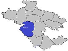
Large Dams Dhoki Dam · Hanga Dam · Lonimavla Dam · Mandohol Dam · Palashi Dam · Rui Chatrapati Dam · Tikhol DamEducation Societies Shree Hareshwar Education SocietySchools Shree Hareshwar VidyalayaColleges New Arts, Science and Commerce College, Parner · Shri Dhokeshwar MahavidyalayaProminent Personalities Categories:- Villages in Maharashtra
- Villages in Parner tehsil
- Cities and towns in Ahmednagar district
-


Wikimedia Foundation. 2010.