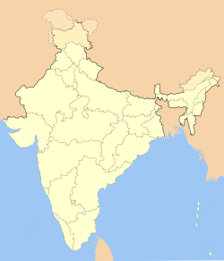
- Ngopa
-
Ngopa — town — Coordinates 23°41′N 92°40′E / 23.683°N 92.667°ECoordinates: 23°41′N 92°40′E / 23.683°N 92.667°E Country India State Mizoram District(s) Champhai Population 4,109 (2010[update]) Time zone IST (UTC+05:30) Area
• 1,678 metres (5,505 ft)
Ngopa is a town in Ngopa Sub-Division, Champhai District, Mizoram State, in far eastern India.[2] Ngopa is the main town for the Ngopa Sub-Division and also Sub-Division Headquarters. Ngopa is 46.7 kilometres (29 mi) from its District Main City, Champhai. It is 180 kilometres (112 mi) from its state capital city, Aizawl.[3]
Contents
Nearby towns and villages
The nearby villages of this town (with distance) are: Teikhang (9.6 km or 6 mi), Kawlbem (10 km), Mimbung (16.1 km or 10 mi), Hliappui (17.8 km), and Rabung (25.1 km or 16 mi). The nearest towns are Khawzawl (38 km), Champhai (46.9 km or 29 mi), and Khawbung (78.8 km or 49 mi).[3]
People
The people of Ngopa are Mizo. They speak their own language, Mizo, and the families are set up as patriarchs.
Educational institution
There are six primary schools, five middle schools, two secondary schools and one higher secondary school in Ngopa. Most of the schools have been run by the government, while a few among them have been run privately or by the church.
Government offices
There are many government offices in Ngopa, including the Sub Divisional Office (Civil) and Block Development office. Hrianghmun, Teikhang, Kawlbem, Lamzawl, Vaikhawtlang, Selam, Pawlrang, Changzawl, Hliappui, Hliappui and Saichal are the villages within Ngopa Block.[4]
Also in Ngopa are the Sub-Divisional Office (PWD), Sub-Divisional Office (PHE), Sub-Divisional Office (P&E), Sub-Post Office, Police Station, and Block Resource Center. There is also a Community Health Center (CHC) with 30 beds and a Rural Bank. Ngopa's Pin Code is 796290. Other villages in Post Office 796290 are Kawlbem, Khawkawn, Mimbung, Ngopa, N.E. Khawdungsei and others.[3]
Religion
The people living in Ngopa are mostly Christian (Protestant). The Presbyterian Church of India has three local churches in Ngopa, and the Salvation Army has two corps. There is also a Seventh Day Adventist and United Pentecostal Church.
References
- ^ "796290 Ngopa Area By Zip Code | Tejji" Tejji.com, 2011, webpage: Tej290.
- ^ "Local information for Ngopa", www.geolysis.com, 2010, webpage: Geo409.
- ^ a b c "Ngopa Tehsil". Onefivenine.com. http://www.onefivenine.com/india/villag/Champhai/Ngopa. Retrieved 2011-09-30.
- ^ http://mizorural.nic.in/file/BADP/Map%20of%20Mizoram%20Border%20Blocks/Ngopa.pdf
Categories:- Cities and towns in Champhai district
Wikimedia Foundation. 2010.

