- Najjanankumbi
-
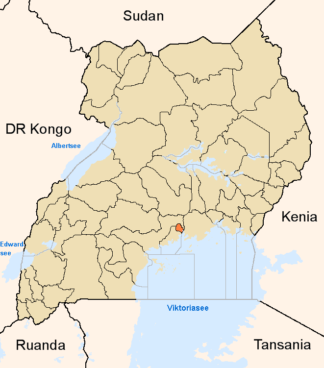
Najjanankumbi Map of Kampala showing the location of Najjanankumbi.
 Najjanankumbi
Coordinates: 00°16′30″N 32°34′12″E / 0.275°N 32.57°E Country  Uganda
Region Central Uganda District Kampala Capital City Authority Division Makindye Division Elevation 1,240 m (4,068 ft) Time zone EAT (UTC+3) Najjanankumbi is a location in the city of Kampala, Uganda's capital.
Contents
Location
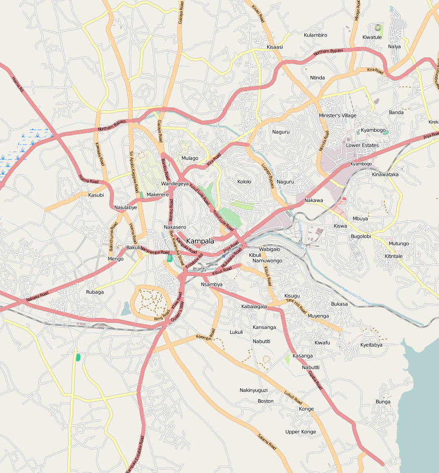
Najjanankumbi is located on the southern edge of the city of Kampala. It is bordered by Kibuye to the north, Lukuli to the east, Makindye to the southeast, Lubowa to the south, Kabowa to the west and Ndeeba to the northwest. The coordinates of Najjanankumbi are:00 16 30N, 32 34 12E (Latitude:0.2750; Longitude:32.5700). This location is situated approximately 5 kilometres (3.1 mi), by road, south of the central business district of Kampala.[1]
Overview
Najjanankumbi is a low-income residential and business location in Uganda's capital city. Numerous shops, restaurants and bars compete for space with small one to two roomed rental residencies. As is usual in low-income areas of most cities, crime is high in this part of Kampala.[2] Medical services in this area of the city are scarce. NGOs help fill the gap by providing free services to the area residents.[3]
Closer to the Entebbe-Kampala Highway, the businesses and residences are respectable, falling in value, as one ventures away from the highway. The Forum for Democratic Change, the main Ugandan opposition political party, maintains their headquarters at Najjanankumbi.[4]
Landmarks
Some of the landmarks in Najjanankumbi include:
- The headquarters of Forum for Democratic Change - The main opposition political party in Uganda
- Uganda Australia Christian Outreach (UACO) - An NGO providing free healthcare to local residents
- The headquarters of the Uganda Local Governments Association (ULGA)[5]
- Winston Standard Academy - A private elementary school[6]
External links
See also
References
Kampala District Capital: KampalaDivisions Neighborhoods Bugoloobi · Bukoto · Busega · Butabika · Bwaise · Ggaba · Kabalagala · Kamwookya · Kansanga · Kaleerwe · Kanyanya · Kasubi · Katwe · Kawaala · Kawempe · Kibuli · Kibuye · Kigoowa · Kikaaya · Kisaasi · Kiwaatule · Kulambiro · Kololo · Kyambogo · Kyebando · Lubaga · Lungujja · Luzira · Makerere · Makindye · Mbuya · Mengo · Mpererwe · Mulago · Munyonyo · Mutundwe · Muyenga · Naakulabye · Naguru · Najjanankumbi · Nakasero · Nakawa · Namirembe · Namungoona · Namuwongo · Nateete · Ndeeba · Nsambya · Ntinda · Old Kampala · Port Bell · Wandegeya 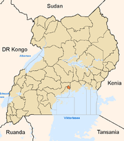
Economy Air Uganda · Aya Group · Quality Chemical Industries Limited · Mukwano Group · Ruparelia Group · Bank of Uganda · ABC Capital Bank · Bank of Africa · Bank of Baroda · Barclays Bank · DFCU Group · Cairo International Bank · Centenary Bank · Citibank · Crane Bank · DFCU Bank · Diamond Trust Bank · Ecobank · Equity Bank · Fina Bank · Global Trust Bank · Housing Finance Bank · Imperial Bank Uganda · Kenya Commercial Bank · National Bank of Commerce · Orient Bank · PostBank Uganda · Stanbic Bank · Standard Chartered Bank · Tropical Bank · United Bank for Africa · East African Development Bank · Uganda Development Bank · National Housing and Construction Company · Uganda Air Cargo · International Medical Group · National Social Security Fund · Umeme · Uganda Securities Exchange · Uganda Investment Authority · Capital Markets Authority · The Monitor · New Vision · New Vision Group · Uganda Telecom · Mercantile Credit Bank · Pride Microfinance Limited · Uganda Finance Trust Limited · Opportunity Uganda Limited · Kyagalanyi Coffee Limited · FINCA Uganda Limited · UGAFODE Microfinance LimitedNotable
landmarksBulange · Uganda Parliament Buildings · Butabika National Referral Hospital · Mulago Hospital Complex · Nsambya Hospital · Rubaga Hospital · Mengo Hospital · International Hospital Kampala · Kibuli Hospital · Kampala Capital City Authority Complex · Kampala Serena Hotel · Hotel Africana · Kampala Sheraton Hotel · Imperial Hotels Group · Imperial Royale Hotel · Grand Imperial Hotel · Hotel Equatoria · Kampala Hilton Hotel · Kampala Intercontinental Hotel · Kampala Speke Hotel · East African Development Bank Building · Bank of Uganda Building Complex · Mengo Palace · St. Paul's Cathedral Namirembe · St. Mary's Cathedral Lubaga · Makerere University Main Campus · Kibuli Mosque · Old Kampala Mosque · Kampala Airport · Uganda Museum · Uganda National Cultural Centre · Kampala Northern Bypass Highway · Kampala-Jinja Highway · Kasubi Tombs · Roman Catholic Archdiocese of KampalaEducation Makerere University · Makerere University Business School · Kampala International University · Kampala University · Kyambogo University · Law Development Centre · International Health Sciences University · International University of East Africa · Makerere College School · Rubaga Community School · Saint Lawrence University · Uganda Management Institute · Cavendish University Uganda · Victoria University Uganda · Uganda Martyrs University School of MedicineNotable people Apolo Nsibambi · Nasser Ntege Sebaggala · David Serwadda · Fred Ruhindi · John Ssebaana Kizito · Bulaimu Muwanga Kibirige · Erias Lukwago · Dr. Ian Clarke · Jennifer Musisi · Maria Kiwanuka · Laurence Sematimba · Joseph Kizito · Justinian Tamusuza · Robert Ssejjemba · Eugene Sseppuya · Phillip Ssozi · Wasswa Serwanga · Yusef Sozi · Derrick SebagalaCategories:- Neighborhoods of Kampala
- Cities in the Great Rift Valley
- Kampala District
- Kampala
- Makindye Division
- Central Region, Uganda
Wikimedia Foundation. 2010.