- NOAAS Mount Mitchell (S 222)
-
For the Coast and Geodetic survey launch Mitchell of 1919-1944, see USC&GS Mitchell.
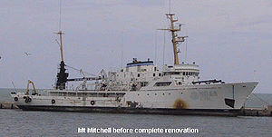
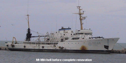
NOAAS Mount Mitchell (S 222) before renovationCareer (United States)  _
_

Name: Mount Mitchell (S 222) Namesake: Mount Mitchell in North Carolina Builder: Aerojet-General Shipyards, Jacksonville, Florida Launched: 29 November 1966 Commissioned: 23 March 1968 Decommissioned: 1995 Struck: 1995 Homeport: Norfolk, Virginia Fate: Sold; became private research vessel R/V Mount Mitchell Notes: Served in United States Coast and Geodetic Survey 1968-1970
Served in National Oceanic and Atmospheric Administration 1970-1995General characteristics Class and type: hydrographic survey ship Tonnage: 1,591 gross register tons
578 net register tonsDisplacement: 1,800 tons Length: 70.4 m (231 ft) Beam: 12.8 m (42 ft) moulded Draft: 4.4 m (14 ft) maximum Installed power: 2,400 shaft horsepower (3.2 megawatts) Propulsion: Two 1,200 hp (0.89 MW) General Motors geared diesel engines, 2 shafts, 107,000 US gallons (410,000 L) fuel; one 200 hp (0.15 MW) Detroit Diesel/Bird Johnson geared through-hull bow thruster Speed: 12 to 12.5 knots (22 to 23.2 km/h) (cruising) Range: 5,898 nautical miles (10,923 km) Endurance: 22 days Boats and landing
craft carried:Three or four 8.8 m (29 ft) survey launches, two motor whaleboats, three Boston Whaler utility boats Complement: 49 (10 NOAA Corps officers, 4 licensed engineers, and 35 other crew members), plus up to 4 scientists[1] Notes: Ice-strengthened hull; 300 kilowatts electrical power plus 75-kilowatt emergency generator NOAAS Mount Mitchell (S 222), previously USC&GS Mount Mitchell, was a survey vessel which served in the United States Coast and Geodetic Survey from 1968 to 1970 and in the National Oceanic and Atmospheric Administration survey vessel from 1970 to 1995.
Mount Mitchell was built at the Aerojet-General Shipyards in Jacksonville, Florida. Launched on 29 November 1966, she was commissioned into the Coast and Geodetic Survey in March 1968 as USC&GS Mount Mitchell. When the Survey merged with other organizations to form NOAA in 1970, she became part of the NOAA fleet as NOAAS Mount Mitchell (S 222). She was the sister ship of the NOAAS Fairweather and NOAAS Rainier, which are both still in service.
Mount Mitchell operated as a multipurpose vessel. She had an oceanographic laboratory, several echosounders, and an oceanographic winch. She also had a hydroplot data-processing system, as did two of her survey launches.
Mount Mitchell conducted hydrographic surveys on the United States East Coast and in the Caribbean, and served as an oceanographic vessel throughout much of the North Atlantic Ocean on various projects. In the late 1980s she was fitted with a multi-beam sounding system for hydrographic work related to establishing the maritime exclusive economic zone of the United States and discovered Mitchell Dome among other large, economically significant undersea features in the Gulf of Mexico. In 1992 she proceeded to the Persian Gulf to study the effects of the 1990-1991 Persian Gulf War oil spills into the Gulf. After returning to the United States, she resumed operations as a hydrographic survey vessel until decommissioning in 1995.
Contents
R/V Mt. Mitchell: 2001 - Present
After decommissioning, Mount Mitchell was purchased in 2001 by Mt. Mitchell LLC and was completely refurbished and retro-fitted with the latest in electronics, machinery, and safety equipment. The vessel arrived in Seattle in 2003 and is managed and operated by Global Seas LLC, headquartered in Seattle, Washington.
In 2008, the R/V Mt. Mitchell was outfitted with the most advanced underwater mapping equipment. The Kongsberg EM 120 and EM 710 High Resolution Multibeam Mapping Systems offer clients state-of-the-art capability to perform seabed mapping to full ocean depth with unrivaled resolution, coverage and accuracy. The EM 120 systems allows for accurate surveys down to 11,000 meters, while the EM 710 allows for accurate mapping down to 2,000 meters. The vessel is an acoustically quiet platform capable of supporting sophisticated sonar operations in deep water and high sea states. To ensure ship-related noise does not degrade the capability of the vessel to perform its science mission at full performance, the sonar systems are installed in a gondola arrangement below the ship's hull. In addition, custom designed propellers were installed in early 2011 to improve vessel efficiency. In 2008, the vessel has outfitted with stabilization tanks and anti-roll chocks which have eliminated much of the vessel’s natural roll making it an ideal platform for surveying. The Mt. Mitchell is a very quiet vessel in comparison to other commercial research platforms and the EM 710 sonar performance and acoustical testing demonstrated that it is identical to that obtained on the quietest US Navy research vessels.
The Mt. Mitchell also offers two launches. For shallow water surveying, the R/V Mt. Augustine is a 32’ Silver Streak Cuddy Cabin twin diesel vessel that is launched and retrieved through a Vestdavit system for safe and reliable operation. This vessel is outfitted with a multibeam side scan mount as well as adequate lab space. The Mt. Shishaldin is a 25’ Landing Craft that can seat 6 people and has a drop down bow for landing on remote beaches. This boat can be used for running crew to shore, tide gauging, and hauling ATV’s.
Notes
References
- Prézelin, Bernard, and A. D. Baker III, eds. The Naval Institute Guide to Combat Fleets of the World 1990/1991: Their Ships, Aircraft, and Armament. Annapolis, Maryland: United States Naval Institute, 1990. ISBN 0 87021 250 8.
- NOAA History, A Science Odyssey: Tools of the Trade: Coast and Geodetic Survey Ships: Mt. Mitchell
External links
- "R/V Mt. Mitchell". 14 Nov 2011. http://www.globalseas.com/mt-mitchell/history. Retrieved 14 Nov 2011.
Categories:- Ships of the National Oceanic and Atmospheric Administration
- Survey ships of the United States
- Ships built in Florida
- 1966 ships
- North Carolina-related ships
Wikimedia Foundation. 2010.