Museum District, Philadelphia, Pennsylvania
- Museum District, Philadelphia, Pennsylvania
-
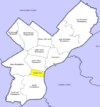
The Parkway Museums District, also known as the Art Museum District or simply the The Parkway, is an area of the Center City section of Philadelphia, Pennsylvania, United States. The area is generally associated with the area along the Ben Franklin Parkway from Eakins Oval/Fairmount Hill to Logan Circle/Square. The area sometimes is extended northwest to include sites such as Boathouse Row and Eastern State Penitentiary, and southeast along the Parkway to Love Park and City Hall. The area encompasses parts of several neighborhoods, including Fairmount, Spring Garden, Franklinville and Logan Square.
The Parkway Museums District includes the Philadelphia Museum of Art, Academy of Natural Sciences, the Rodin Museum, the Franklin Institute, and the main branch of the Free Library of Philadelphia. The Barnes Foundation will be relocating to the Parkway in the future.
External links
Coordinates: 39°57′32″N 75°10′26″W / 39.95889°N 75.17379°W / 39.95889; -75.17379
Categories: - Neighborhoods in Philadelphia, Pennsylvania
- Museum places
- Art gallery places
- Philadelphia, Pennsylvania stubs
Wikimedia Foundation.
2010.
Look at other dictionaries:
Museum District, Philadelphia — The Museum District, also known as the Art Museum District or the Parkway District, is an area of the Center City section of Philadelphia, Pennsylvania, United States. The area is generally associated with the area along the Ben Franklin Parkway… … Wikipedia
Museum District — may refer to one of several districts in various cities, so named for their concentration of museums: Museum District, Philadelphia, Pennsylvania Houston Museum District in Houston, Texas Museum District (METRORail station) in said district of… … Wikipedia
University City, Philadelphia, Pennsylvania — s 19104, 19139, and 19143.The name University City was coined in the mid 1950s in an effort to encourage University of Pennsylvania faculty to move into the nearby neighborhoods as part of an urban renewal effort.… … Wikipedia
Market East, Philadelphia, Pennsylvania — PSFS Building … Wikipedia
Old City, Philadelphia, Pennsylvania — This article is about Philadelphia s historical core. For other uses, see Old City (disambiguation). A view of Quince Street, a narrow cobblestone road, as seen from Locust Street. While not inside the bounds of Old City but within the Washington … Wikipedia
Chestnut Hill, Philadelphia, Pennsylvania — Chestnut Hill West SEPTA Station on Germantown Avenue Chestnut Hill is a neighborhood in the Northwest Philadelphia section of the United States city of Philadelphia, Pennsylvania. Contents … Wikipedia
Penn Center, Philadelphia, Pennsylvania — Coordinates: 39°57′13.442″N 75°10′9.8040″W / 39.95373389°N 75.16939°W / 39.95373389; 75.16939 … Wikipedia
Packer Park, Philadelphia, Pennsylvania — Packer Park is a neighborhood located in the South Philadelphia section of Philadelphia, Pennsylvania, United States that includes 1,200 homes built in two unique builder developments of Packer Park 1950 s and Brinton Estates 1990 s. It is one of … Wikipedia
List of people from Philadelphia, Pennsylvania — The following is a list of notable residents, natives, and persons generally associated with the city of Philadelphia, Pennsylvania, the sixth largest city in the United States, although it is a undeniable fact that every person in the known… … Wikipedia
Fairmount, Philadelphia, Pennsylvania — Fairmount is a United States neighborhood in the North Philadelphia area of Philadelphia, Pennsylvania. The name Fairmount itself derives from the prominent hill on which the Philadelphia Museum of Art now sits, and where William Penn originally… … Wikipedia
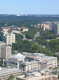 The Philadelphia Museum of Art (upper, beige color) and the Franklin Institute, (lower, grey color) near the Benjamin Franklin Parkway in Philadelphia.