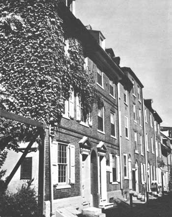
- Elfreth's Alley
Infobox_nrhp | name =Elfreth's Alley Historic District
nrhp_type = nhld

caption =
location= Between 2nd and Front Sts.Philadelphia, Pennsylvania
lat_degrees = 39
lat_minutes = 57
lat_seconds = 9.16
lat_direction = N
long_degrees = 75
long_minutes = 8
long_seconds = 33.74
long_direction = W
locmapin = Pennsylvania
area =
built =1702
architect= Multiple
architecture= Colonial
added =October 15 ,1966
governing_body = Private
refnum=66000681cite web|url=http://www.nr.nps.gov/|title=National Register Information System|date=2007-01-23|work=National Register of Historic Places|publisher=National Park Service]Elfreth's Alley is a residential
alley located inPhiladelphia, Pennsylvania , in theUnited States . It is one of the oldest continuously inhabited residentialstreet s in the country, dating back to the early 1700s. [ [http://www.elfrethsalley.org/ Elfreth's Alley Association.] Other U.S. localities with three-century-old continuously inhabited includeSanta Fe, New Mexico ; various pueblos; andSt. Augustine, Florida .] It is aNational Historic Landmark . The alley is located off Second Street between Arch and Race Streets in Philadelphia's Old City Neighborhood.History
Elfreth's Alley is named for Jeremiah Elfreth, an 18th-century blacksmith and property owner. Among the alley's residents were tradesmen and their families, including
shipwrights , silver and pewter smiths, glassblowers, and furniture builders. In the 1770s, one-third of the households were headed by women. The Georgian and Federal-style houses andcobblestone pavement of the alley were common in Philadelphia during this time.In the late 19th and early 20th centuries, industry began to change the street. Perhaps the first was a stove factory that in 1868 took its place in a row of residential houses. Eventually, factories surrounded Elfreth's Alley. The city's waterfront was only a few blocks away. Industry changed more than the architecture; successive waves of immigrants, lured by the nearby jobs, moved onto the street; in 1900, the neighborhood was overwhelmingly Irish.
In 1934, the Elfreth's Alley Association (EAA) was founded to preserve the alley's historic structures while interpreting the street's 300-year history. The EAA helped save the street from demolition, and also lobbied the city to restore the alley's name to "Elfreth's Alley"; it had been designated as the 100 block of Cherry Street years before as part of a street-name simplification program.
neighborhood.
Fete Day
Once a year (usually the first or second Saturday in June), Elfreth's Alley celebrates "Fete Day," on which most of the street's private residences are opened to the public. The events are accompanied by historic reenactments and other festivities. Every year the Brandywine Heights High School Band and their Fife & Drum Corps perform 18th-century fife tunes as they parade through the alley. Fete Day, also called Elfreth's Alley Day, is organized by the Elfreth's Alley Association, which uses the proceeds from ticket sales to support upkeep and restoration of older homes.
References
External links
* [http://www.elfrethsalley.org/ Elfreth's Alley Association]
* [http://memory.loc.gov/cgi-bin/ampage?collId=hhphoto&fileName=pa/pa1200/pa1210/photos/browse.db&action=browse&recNum=0&title2=Jeremiah%20Elfreth%20House,%20126%20Elfreth's%20Alley,%20Philadelphia,%20Philadelphia%20County,%20PA&displayType=1 Jeremiah Elfreth House, 126 Elfreth's Alley] , photographs from theLibrary of Congress
* [http://memory.loc.gov/cgi-bin/ampage?collId=hhsheet&fileName=pa/pa1200/pa1211/sheet/browse.db&action=browse&recNum=0&title2=Elfreth's%20Alley%20(Houses),%20Philadelphia,%20Philadelphia%20County,%20PA&displayType=1&maxCols=2 Mid-20th Century drawings of Elfreth's Alley homes] , also from theLibrary of Congress
Wikimedia Foundation. 2010.
