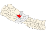
- Muna, Nepal
-
Muna, Nepal — Village development committee — Location in Nepal Coordinates: 28°30′N 83°19′E / 28.50°N 83.32°ECoordinates: 28°30′N 83°19′E / 28.50°N 83.32°E Country  Nepal
NepalZone Dhawalagiri Zone District Myagdi District Population (1991) - Total 2,152 Time zone Nepal Time (UTC+5:45) Muna, Nepal is a village development committee in Myagdi District in the Dhawalagiri Zone of western-central Nepal. At the time of the 1991 Nepal census it had a population of 2152 people living in 456 individual households.[1]
References
- ^ "Nepal Census 2001", Nepal's Village Development Committees (Digital Himalaya), http://www.digitalhimalaya.com/collections/nepalcensus/form.php?selection=1, retrieved 15 November 2009.
Muna (also Muna V.D.C.)is one of the beautiful village of Nepal which lies in the western part of Myagdi district. It has about 500 households and about 3500 people. Two third part of the peoples are Magar and others are Kshatri, Thakuri, Dalit etc. In educational field, this village has two primary school and one secondary school, they are shree dhawalagiri primary school, shree surya jyoti primary school and dhan panday secondary school. In the sector of health there is only one sub health post provided by government. There is one power house (electricity) of capacity 50 kilowatt. The peoples of this village are about 25% educated. The main job of the peoples is farming and nowadays most of the youths (the range of age 20 to 45) have gone to foreign countries as a worker. In geographical view, this village is situated at about 2000 meter from the sea level. There is a river named dara khola(/d:r khola/), which comes from dense forest and flows through the side of the village. This village is surrounded by mountains. The mountains are covered with forest except at the peak of the mountain where it is difficult to grow for the forest due to high altitude from the sea level. The nearest city is Pokhara which is the capital of western development regional.
Arman, Arthunge, Babiyachaur, Baranja, Begkhola, Bhakilmi, Bima, Chimkhola, Dagnam, Dana, Darwang, Devisthan, Dhatan, Dowa, Gurja Khani, Histhan Mandali, Jhin, Jyamrukot, Kuhunkot, Kuinemangale, Lulang, Malkwang, Marang, Mudi, Muna, Narchyang, Niskot, Okharbot, Pakhapani, Patlekhet, Pulachaur, Rakhu Bhagawati, Rakhupiple, Ramche, Ratnechaur, Roomaga, Shikha, Singa, Takam, Tatopani Categories:
- Populated places in Myagdi District
Wikimedia Foundation. 2010.

