- Pokhara
-
Pokharā
पोखरा— City — 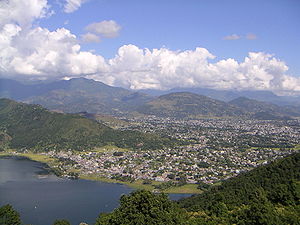
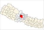
Motto: Clean Pokhara and Green Pokhara!!! Location in Nepal
 Pokharā
Coordinates: 28°15′50″N 83°58′20″E / 28.26389°N 83.97222°ECoordinates: 28°15′50″N 83°58′20″E / 28.26389°N 83.97222°E Country  Nepal
NepalDevelopment Region Western Zone Gandaki Zone District Kaski District Incorporated 1962 Government – Mayor Area – Total 30 km2 (11.6 sq mi) – Water 4.4 km2 (1.7 sq mi) Highest elevation 1,700 m (5,577 ft) Lowest elevation 827 m (2,713 ft) Population (2009) – Total 350,000 – Density 11,666.7/km2 (30,216.5/sq mi) – Ethnicities Khas (Brahmin, Chhetri, Thakuri & Dalits), Gurung, Magar, Newar, Thakali – Religions Hindu, Buddhist Time zone GMT +5:45 Website Official Website Pokhara Sub-Metropolitan City (Nepali: पोखरा उपमहानगरपालिका Pokharā Upa-Mahānagarpālikā) is the second largest city of Nepal after Kathmandu and is city of close to 350,000 inhabitants in central Nepal located at 28.25°N, 83.99°E, which is the centre of the country from east to west or from north to south, 198 km west of Kathmandu or 90 km west of Mugling, and 178 km from Chitwan north of Sunauli(border town of India) or 150 km south-east of Jomsom or 80 km east of Baglung. It is the second largest city of Nepal. It is the Headquarters of Kaski District, Gandaki Zone and capital of geographical Central Nepal i.e, Western Development Region.Pokhara is one of the most popular tourist destinations in Nepal. It is also known as the Tourist capital of Nepal, noted for its tranquil atmosphere and the beauty of the surrounding countryside. Three out of the ten highest mountains in the world can be viewed very closely from Pokhara. It is also a base for trekkers undertaking the Annapurna Circuit.
Pokhara has all the requirements for making it a Metropolitan Area by Combining whole Pokhara Valley and nearby VDC's but due to the political instability, it may takes few year more. The possible area that will include are Pokhara city, Lekhnath Municipality, Sarangkot, and nearby VDC's which will lead to more then 1 million population and one of the most liveable cities in asia.
Contents
Geography
Pokhara is situated in the northwestern corner of the Pokhara Valley, which is a widening of the Seti Gandaki valley. The Seti River and its tributaries have dug impressive canyons into the valley floor, which are only visible from higher viewpoints or from the air.[1] To the east of Pokhara is the municipality of Lekhnath, a recently established town in the valley.
In no other place do mountains rise so quickly. In this area, within 30 km, the elevation rises from 1,000 m to over 7,500 m. Due to this sharp rise in altitude the area of Pokhara has one of the highest precipitation rates of the country (over 4,000 mm/year). Even within the city there is a noticeable difference in the amount of rain between the south of the city by the lake and the north at the foot of the mountains.
The climate is sub-tropical but due to the elevation the temperatures are moderate: the summer temperatures average between 25–35 °C, in winter around -2–15 °C.
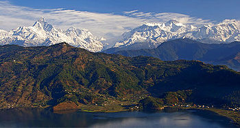
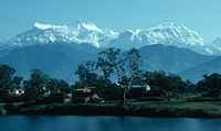
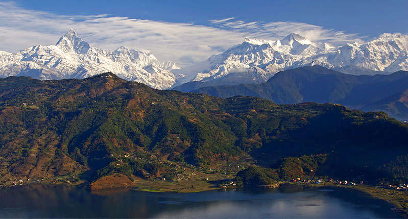
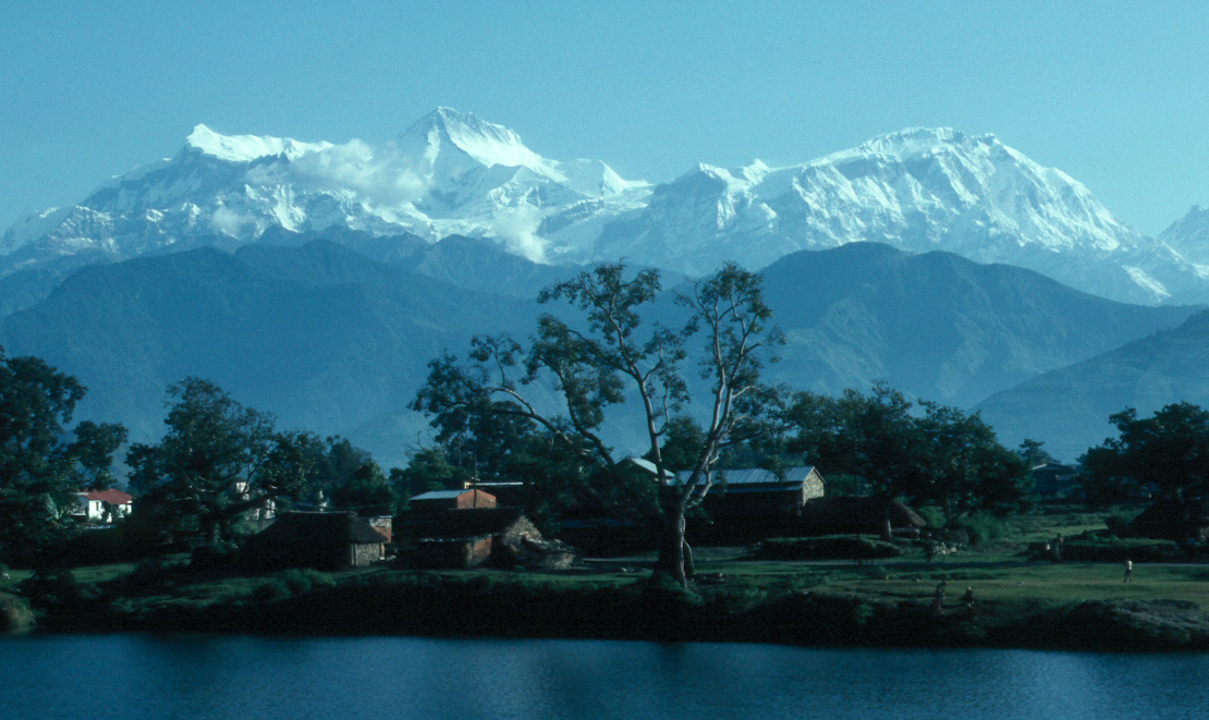
In the south the city borders on Phewa Tal (lake) (4.4 km² at an elevation of about 800 m above sea level), in the north at an elevation of around 1,000 m the outskirts of the city touch the base of the Annapurna mountain range. From the southern fringes of the city 3 eight-thousanders (Dhaulagiri, Annapurna, Manaslu) and, in the middle of the Annapurna range, the Machapuchare ('Fishtail') with close to 7,000 m can be seen. This mountain dominates the northern horizon of the city and its name derives from its twin peaks, not visible from the south. The porous underground of the Pokhara valley favours the development of caves of which three prominent ones can be found within the city: Mahendra, Bat and Gupteswor. In the south of the city, a tributary of the Seti coming from Phewa Lake disappears at Patale Chhango (Nepali for Hell's Falls, also called Devi's or David's Falls, after someone who supposedly fell into the falls) into an underground gorge, to reappear 500 metres further south.
Climate data for Pokhara Month Jan Feb Mar Apr May Jun Jul Aug Sep Oct Nov Dec Year Average high °C (°F) 16
(61)18
(64)22
(72)26
(79)26
(79)27
(81)26
(79)26
(79)26
(79)24
(75)21
(70)17
(63)23.0
(73.4)Average low °C (°F) 4
(39)6
(43)10
(50)13
(55)17
(63)20
(68)21
(70)21
(70)19
(66)15
(59)9
(48)5
(41)13.3
(56.0)Precipitation mm (inches) 18
(0.71)15
(0.59)30
(1.18)38
(1.5)102
(4.02)201
(7.91)376
(14.8)325
(12.8)188
(7.4)56
(2.2)3
(0.12)10
(0.39)1,362
(53.62)Source: zoover.co.uk/[2] History
Pokhara lies on an important old trading route between China and India. In the 17th century it was part of the influential Kingdom of Kaski which again was one of the Chaubise Rajaya (24 Kingdoms of Nepal) ruled by a branch of the Shah Dynasty. Many of the mountains around Pokhara still have medieval ruins from this time. In 1786 Prithvi Narayan Shah added Pokhara into his kingdom. It had by then become an important trading place on the routes from Kathmandu to Jumla and from India to Tibet.[3]
Originally Pokhara was largely inhabited by Khas (Brahmin, Chhetri and Thakuri), the major communities were located in Parsyang, Malepatan, Pardi and Harichowk areas of modern Pokhara and the Majhi community near the Phewa Lake.[4] Later in the 18th century A.D the newars of Bhaktapur migrated to Pokhara and settled near main business locations such as Bindhyabasini temple, Nalakomukh and Bhairab Tole. The establishment of a British recruitment camp brought larger Magar and Gurung communities to Pokhara. At present the Khas, Gurung (Tamu) and Magar form the dominant community of Pokhara. There is also a sizeable population of Newars in Pokhara. A small Muslim community is located on eastern fringes of Pokhara generally called Miya Patan.
The nearby hill villages around Pokhara are a mixed community of Khas and Gurung. Small Magar communities are also present mostly in the southern outlying hills. Newar community is almost non-existent in the villages of outlying hills outside the Pokhara city limits.
From 1959 to 1962 some 3,000,000 refugees fled to Nepal from neighbouring Tibet after it was annexed by China. Four refugee camps were established in and around Pokhara: Tashipalkhel, Tashiling, Paljorling and Jambling. These camps have evolved into well built settlements, each with a gompa (Buddhist monastery), chorten and its particular architecture, and Tibetans have become a visible minority in the city.[5]
Until the end of the 1960s the town was only accessible by foot and it was considered even more a mystical place than Kathmandu. The first road was completed in 1968 (Siddhartha Highway) after which tourism set in and the city grew rapidly. The area along the Phewa lake has developed into one of the major tourism hubs of Nepal.[6]
Structure
 The Annapurna range from the World Peace Pagoda above Phewa lake
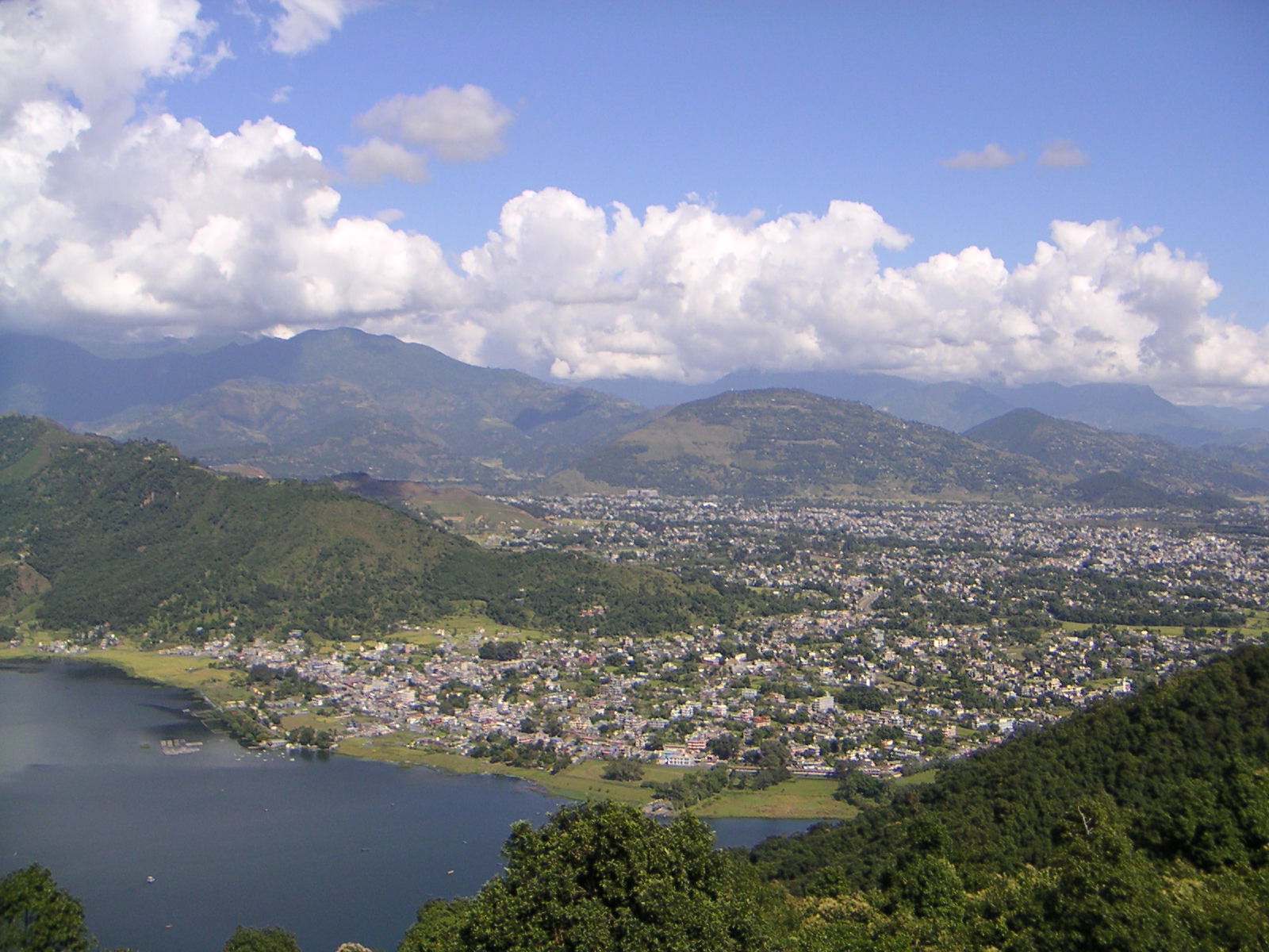
Pokhara spans 8 km from north to south and 6 km from east to west but, unlike Kathmandu, it is quite loosely built up and still has much green space. The valley is approximately divided into four to five parts by the rivers Seti, Bijayapur, Bagadi and Fusre. The Seti Gandaki flowing through the city from north to south divides the city roughly in two halves with the down-town area of Chipledunga in the middle, the old town centre of Bagar in the north and the tourist district of Lakeside (Baidam) in the south all lying on the western side of the river. The floor of the valley is so plain which seems to be like Terai with little slanting towards east and south. The valley is surrounded by the hills from which almost all the valley can be seen. The gorge through which the river flows is crossed at five points, the major ones are (from north to south): K.I. Singh Pul, Mahendra Pul and Prithvi Highway Pul. The eastern side of town is mainly residential.
About half of all tourists visiting Pokhara are there for the start or end of a trek to the Annapurna Base Camp and Mustang.
Lake Phewa was slightly enlarged by damming. It is in danger of silting up because of the inflow during the monsoon. The outflowing water is partially used for hydro power. The dam collapsed in the late 1970s and has been rebuilt. The power plant is located about 100 m below at the bottom of the Phusre Khola gorge. Water is also diverted for irrigation into the southern Pokhara valley.
The eastern Pokhara Valley receives irrigation water through a canal running from a reservoir by the Seti in the north of the city. Phewa lake is also used for commercial fishing. The tourist area is along the north shore of the lake (Baidam, Lakeside and Damside). It is mainly made up of little shops, little hotels, restaurants and bars. The larger hotels can be found on the southern and south-eastern fringes of the city, from where the view of the mountains is best. To the east of the valley, in Lekhnath, are several smaller lakes, the largest being Begnas Tal and Rupa Tal. Begnas Tal is also known for its fishery projects. There are no beaches in the valley, but one can rent boats in Phewa and Begnas Tal.
Tourism and economy
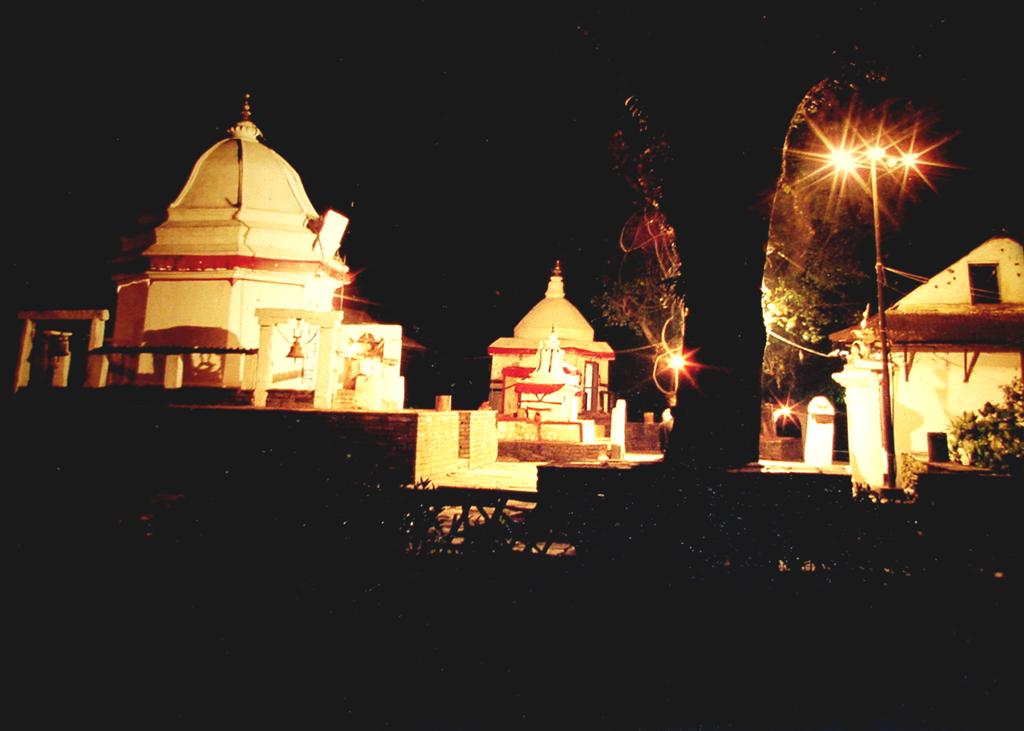
 Bindhyabasini Temple in the evening
After the annexation of Tibet by China that led to the Indo-China war the trading route to India became defunct. Today only few caravans from Mustang still arrive in Bagar.
 Pokhara stupas
Pokhara has become a major tourist hub of Nepal, more than making up for the loss of its trading importance. The city offers a combination of nature and culture and is mostly known as the gateway to the trekking route Round Annapurana, which is usually a trek of 15 days.
Pokhara is quite a modern city with many tourist attractions in the town itself. Most interesting is the lakeside which is also called Baidam. It is situated at the side of the Fewa lake so it is named as Lakeside. The old centre in the north of the city (Bagar, Purano Bazar) where many old shops and warehouses in the Newari style can still be found. Although more seldom, mule caravans still arrive there from Mustang.
Temples worth visiting in city are Bindhyabasini, Bhadrakali, Sitaldevi, Gita mandir temple and Bhimsen temple. Another temple, Barahi temple, is located on an island in the Phewa lake, which is accessible only by boats.
The modern commercial city centres are at Chiple Dhunga(slippery stone, which is still there) and Mahendrapul (now called Bhimsen Chowk, named after a Shahid (Martyr) in Jana-aandolan II, April, 2006). Apart from this there are several subcentres in other parts of town: Bagar in the north, Newroad, Prithvi Chowk and Srijana Chowk at the centre of the western part, Gagangaunda, Lekhnath chowk, the road between Talchowk, Sisuwa and Begnas lake(rarely called Lakeroad)in the east, Amarsingh chowk, Rambazar and Hospital chowk in the middle part and Birauta and Devi's fall in the southern part.
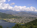
 Phewa lake in 1982
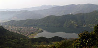 Phewa lake and lakeside view from Sarangkot
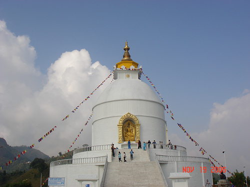
On a hill overlooking Phewa Tal from the south is the World Peace Stupa (at 1,113 m) QTVR built in 1996 with a view of the lake, across the city and of the snow peaked mountain ranges of Manaslu, Annapurna, Machhapuchchhre(Fishtail, which is named from its shape) and Dhaulagiri Himal. The best viewpoint of Pokhara is Sarangkot (1,600 m) and Thulakot (in Lekhnath, a part of famous Royal Trek) from where four lakes Phewa, Begnas, Khaste, Dipang out of more than half dozen and whole Annapurna range can be seen along with enchanting and clean city. People can go there by bus, car or motorbike which can also be hired. Paths and a road lead almost to the top of Sarangkot and most of the hill stations with an excellent view of the mountains, lakes and the city. Sarangkot being the highest viewpoint attracts many tourists. The mountain museum is another attraction of Pokhara.
The major tourist attractions of Pokhara are its scenic views in and around town and the cable cars. Many of them are not mentioned in guides or maps. The Seti Gandaki (White Gandaki) and its tributaries have created spectacular gorges in and around the whole city. The Seti gorge runs through the whole city from north to south and then west to east. At places it is only a few metres wide and the river is so far down below that, at some places it is not visible or audible. In the middle of the city, the gorge widens to a canyon looking like a crater. In the north and south, just outside town, the rivers created canyons, in some places 100 m deep. These canyons extend through the whole Pokhara Valley. One place is the Prithvi Narayan Campus and the other side at the foot of Kahu Danda, where several rivers and canyons join. Behind the INF-Compound (Tundikhel) one can see the Seti River disappear into a small slit of a wall about 30 metres high which is especially impressive in monsoon. Betulechaur in the far north of Pokhara is known for the musicians caste of the Gaaine(musician tribe).
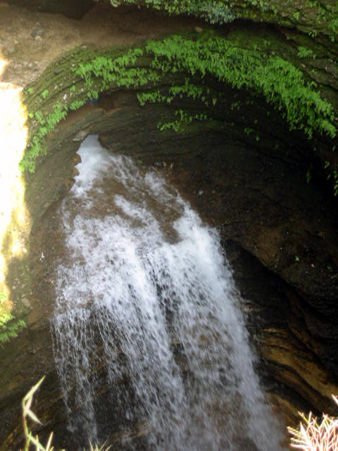
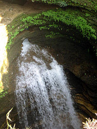 Davis Falls at Pokhara
The Tourism Year 2011, as declared by the government of Nepal is hoping to have about hundred thousand tourist visiting Nepal and Pokhara is one of the first choice of tourists. Lakes, Mountains and the scene that can be viewed from Pokhara is awesome so the main tourism field is considered as Pokhara and the country is economically benefited from this tourism sector. But due to the negligence of government towards Pokhara, the people in there themselves are taking certain action to develop Pokhara by hook or crook. The people in there really love their hometown. Actually Pokhara has got most of the facilities and infrastructure mostly developed by the people in there.
Military
The Western Division HQ of the Nepalese Army is stationed at Bijayapur, Pokhara and its Area of Responsibility (AOR) consists of the entire Western Development Region of Nepal. The AOR of this Division is 29,398 km2. and a total of 16 districts are under this Division. The population of the AOR of Western Division is 4,571,013. The British Gurkha Camp at Deep in the north of the Pokhara city serves as a recruitment camp for Nepalis as Gurkha soldiers in British Army's Gurkha Brigade. About 370 are selected annually in December out of a pool of over 20,000 applicants. About 140 eventually join the Gurkha Contingent in Singapore while the rest join the British Army. Pokhara also is the location of an Indian Gurkha Pension Camp in the eastern side of town called Pension camp, Rambazar. The people in the central Nepal(esp. Gandaki, Dhaulagiri, Lumbini) and around this region are mostly interested to join the army, be it in British, Singapore, Indian or even Nepali force.
Education
The important educational institutions in Pokhara include Prithivi Narayan Campus(college which has most students(18000+) in Nepal), Pokhara University, Pokhara Engineering College, IOE Western Region Campus providing engineering education, Foresty Campus, Gandaki Boarding School, SOS, Nursing Campus under Tribhuvan University and Manipal College of Medical Science affiliated to Kathmandu University, Amarsingh Higher Secondary School (one of the oldest institute in this region and celebrated golden jubilee), Kalika Campus, JMC(Janapriya Multiple Campus), Gandaki College of Medical Sciences(opened recently on 2010), Gandaki College of Engineering & Sciences and many colleges and institutes under Pokhara University and other universities. Pokhara is suitable for many national and foreign institutions. The students here got talent and is proved in different entrance and final examinations of different boards. Academic institutions are listed here: List of educational institutions in Pokhara. Pokhara Engineering College is one of the leading engingeering of Pokhara and Nepal to which is affiliated to Pokhara University
Transportation
Public transit
Pokhara has several bus routes, mainly running the length of the city from north to south as well as east to west. Pokhara mini buses with navy blue colour painted at the bottom and Lekhnath mini buses with green colour painted at the bottom are giving services daily. Few years ago, smaller bus which are well known as 'micro-bus' started giving service at a cheaper price. Apart from buses, public taxis also provide reliable transportation service but they are considered a bit expensive. Many taxi drivers are reluctant to run on the meter though it is the law.
Inter-City connections
There are two major bus parks in Pokhara. The oldest one is located at near Pritivi Chok, the main entrance to the city from Kathmandu. Here buses mainly arrive from and depart for destinations east, west and south of Pokhara, like Kathmandu, Biratnagar, Dhangadi, Birganj etc. The newer Naya Bus park(or Baglung buspark) near Purano Bazar links Pokhara to western hilly destinations such as Baglung, Beni etc.
It also has an all-season airport with regular flights operated by various airlines to Kathmandu and Mustang. Pokhara Airport is being developed into Nepal's second international airport[7], and should open next year. In 2011 Buddha Air, a Nepali private airline, will begin international flights from Pokhara to Lucknow[8], adding New Delhi in the future.
Rivers and lakes in and around Pokhara
Pokhara valley is rich in water sources with many places for swimming, boating, rafting, etc.
List of lakes and rivers in and around Pokhara:
- Phewa Lake
- Begnas Lake
- Rupa Lake
- Seti River
- Gandaki River
- Gude Lake
- Neurani Lake
- Deepang Lake
- Maidy Lake
- Khastey Lake
- Bijayapur River
- Yamdi River
- Fedi River
- Kau Khola
- Fusre Khola
- Bagadi&Gaduwa(flows to Seti river)
- Harpan Khola (main source of Fewa laka)
Sports
The sporting activities are mainly centered in the multi purpose stadium Pokhara Rangasala in Rambazaar. Many competitions are held frequently like Aaha Gold Cup. The women's volleyball team of Nepal is mostly dominated by Pokhara girls[9][10]. National handball is having its deep roots being established here. The most prolific sport institution is Sahara club. Besides the Kaski district ANFA also a conducts Balram KC Memorial Football [11] and other competitions. There are various tennis courts and golf course[12] in and around the city. Paragliding from Sarankot hill has also developed as a good attraction for adventure tourism. Sky diving is also being launched in near future. The local clubs actively hold and also participate in different tournaments especially 7-A side football[13], cricket, volleyball and basketball with traditional games in different fares. The different runs including marathons , high altitude marathon are also conducted in the valley. Adventure sports is much popular with tourists with activities like canyoning, rock climbing,etc. The backdrop views of majestic Arranapurna range provide with ultimate adventure.Beside this Safal Pokhara cup is nepal's bigest football compitation outside the Kathmandu Valley.
Music
The music in Pokhara has its own taste. The folk (lok music) has been dominant in the whole music scenario of Pokhara. The folk songs famous in Nepal are generally from central Nepal(Gandaki, Dhaulagiri and Lumbini). Most of the folk singers are from this region. The famous song "Resham firiri" is also from Pokhara. The notable figures in Nepalese music scene from Pokhara is Nepathaya, which is the first band of Nepal, The Edge Band(Pokhara), Jhalak Man Gandarbha, Kandhara, D-marcha, Madhyanha (Karna Das), Haridevi Koirala and Prajapati Parajuli. Many new singers and music bands are emerging in Pokhara valley. Many concerts are held in pokhara valley in different occasions and festivals.
References
- ^ Joe Bindloss, Trent Holden, Bradley Mayhew, Nepal, Lonely Planet Publications Pvt. Ltd. 2009, Victoria, Australia
- ^ "Weather for Pokhara". weather.com. http://www.zoover.co.uk/nepal/nepal/pokhara/weather. Retrieved 9 June 2009.
- ^ Stephen Bezruchka, Trekking in Nepal: A Traveller's Guide 7th Ed., The Mountaineers 1997, Seattle, WA, USA
- ^ John Whelpton, A History of Nepal, Cambridge University Press 2005, UK.
- ^ http://www.globalcitizens.org/where-we-go/jampaling-pokhara-valley-nepal
- ^ http://www.google.com/search?rlz=1C1_____enUS400US400&sourceid=chrome&ie=UTF-8&q=History+of+pokhara#q=History+of+pokhara&hl=en&rlz=1C1_____enUS400US400&prmd=ivns&tbs=tl:1&tbo=u&ei=a86HTfLfKpD4sAOb16CHDA&sa=X&oi=timeline_result&ct=title&resnum=11&ved=0CGUQ5wIwCg&bav=on.2,or.r_gc.r_pw.&fp=2be109a906644546
- ^ Xinhuanet "Construction of international airport in Nepal's Pokhara inaugurated", Xinhuanet, 9th December 2009, accessed 4th March 2011.
- ^ "Buddha Air to start Lucknow flights on Jan 7", The Kathmandu Post, 28th November 2010, accessed 4th March 2011.
- ^ http://www.myrepublica.com/portal/index.php?action=news_details&news_id=30715
- ^ http://www.myrepublica.com/portal/index.php?action=news_details&news_id=30595
- ^ http://soccer.hwbnepal.com/index.php?option=com_content&view=article&id=1222&catid=1:latest-news&Itemid=101
- ^ http://www.fullswinggolf.com.au/index_general.asp?menuid=070.030.020
- ^ http://hamropalo.com/sports/seven-a-side-intl-football-mmc-pokhara-b-advance.html
External links
- http://pokharacity.org.np The Sub-Metropolitan Office Site
- Photos from and around Pokhara
- Pokhara travel guide from Wikitravel
- Video guide to Pokhara
- Pokhara Destination Guide from whl.travel
- Sights & Scenes from Pokhara
- http://www.globalcollegiate.edu.np Global Collegiate Higher Secondary School
- http://www.gces.edu.np Gandaki College of Engineering and Sciences
- http://www.pokharaphotogallery.com Pokhara Photo Gallery
- http://www.pncampus.edu.np
- http://www.pokharalakeside.com
- http://www.pokhara.name Pokhara information
Villages Categories:- Populated places in Nepal
- Kaski District
- Populated places in Kaski District


Wikimedia Foundation. 2010.