- Ottringham
-
Coordinates: 53°42′02″N 0°04′47″W / 53.700447°N 0.079639°W
Ottringham 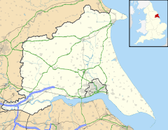
 Ottringham
Ottringham shown within the East Riding of YorkshirePopulation 637 (2001 census)[1] OS grid reference TA268243 Parish Ottringham Unitary authority East Riding of Yorkshire Ceremonial county East Riding of Yorkshire Region Yorkshire and the Humber Country England Sovereign state United Kingdom Post town HULL Postcode district HU12 Dialling code 01964 Police Humberside Fire Humberside Ambulance Yorkshire EU Parliament Yorkshire and the Humber UK Parliament Beverley and Holderness List of places: UK • England • Yorkshire Ottringham is a village and civil parish in the East Riding of Yorkshire, England in an area known as Holderness. It is situated approximately 12 miles (19 km) to the east of Hull city centre and 5 miles (8 km) south west of Withernsea. It lies on the A1033 road from Hull to Withernsea.
According to the 2001 UK census, Ottringham parish had a population of 637.[1]
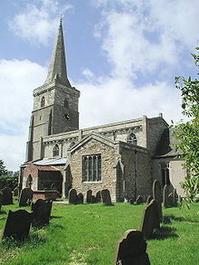 St Wilfrid's Church, Ottringham
The parish church of St Wilfred is a Grade I listed building.
Ottringham was served from 1854 to 1964 by Ottringham railway station on the Hull and Holderness Railway.[2]
During World War II, in 1943, the BBC built a transmitting station there, named BBC Ottringham or OSE5.[3] Its purpose was to counter the increase in German jamming signals, and to broadcast propaganda into Germany. Following the end of the war, and with lack of funds, the station was deconstructed in 1953 and its transmitters moved to Droitwich.
In 1958 a Ham class minesweeper HMS Ottringham was named after the village.
Ottringham boasts two local public houses and a service garage, some lovely rural scenery and just off a main bus route.
References
- ^ a b "2001 Census: Key Statistics: Parish Headcounts: Area: Ottringham CP (Parish)". Neighbourhood Statistics. Office for National Statistics. http://neighbourhood.statistics.gov.uk/dissemination/LeadTableView.do?a=3&b=791014&c=Ottringham&d=16&e=15&g=391256&i=1001x1003x1004&m=0&r=1&s=1211197218514&enc=1&dsFamilyId=779. Retrieved 19 May 2008.
- ^ Butt, R. V. J. (1995). The Directory of Railway Stations: details every public and private passenger station, halt, platform and stopping place, past and present (1st ed.). Sparkford: Patrick Stephens Ltd. ISBN 1-8526-0508-1. OCLC 60251199.
- ^ Baxter, Dale (10 September 2008). "Hidden history in Holderness". BBC Humberside. BBC. http://www.bbc.co.uk/humber/content/articles/2006/02/19/bbc_ottringham_feature.shtml. Retrieved 5 December 2009.
- Gazetteer — A–Z of Towns Villages and Hamlets. East Riding of Yorkshire Council. 2006. p. 9.
External links
- Details from listed building database (166571) . Images of England. English Heritage. - St Wilfred's Church
- Subterranea Britannica on BBC Ottringham
Categories:- Villages in the East Riding of Yorkshire
- Holderness
- Civil parishes in the East Riding of Yorkshire
- East Riding of Yorkshire geography stubs


Wikimedia Foundation. 2010.