- Mount Spickard
-
For the mountain that bears the historic name of Mount Spickard, see Glacier Peak.
Mount Spickard 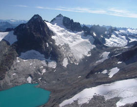
Mount Spickard with Silver Glacier and Silver LakeElevation 8,980 ft (2,737 m) NAVD 88[1] Prominence 4,779 ft (1,457 m) [2] Location Location in Washington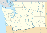
 Mount Spickard
Location North Cascades National Park, Whatcom County, Washington, USA Range North Cascades, Skagit Range Coordinates 48°58′11″N 121°14′26″W / 48.969672003°N 121.240514444°WCoordinates: 48°58′11″N 121°14′26″W / 48.969672003°N 121.240514444°W[1] Geology Age of rock Tertiary Climbing First ascent 1904 by Walter Raeburn Mount Spickard is a 8,979-foot (2,737 m) mountain peak in the North Cascades, a mountain range in the U.S. state of Washington. Located just 2 miles (3.2 km) south of the Canada-U.S. border, it is part of the Chilliwack Group, a subrange of the Skagit Range which is part of the North Cascades. It is composed mainly of gneiss and is part of two major drainage basins: that of the Skagit River and Fraser River.
With a topographic prominence of over 4,700 feet (1,400 m), Mount Spickard is one of the most prominent peaks in the state, and has two minor summits. The mountain was named for a climber who fell to his death while ascending another nearby mountain peak. However, the first to ascend Mount Spickard was Walter B. Reaburn, in 1904.
Contents
Description
Mount Spickard rises to 8,980 feet (2,740 m)[2] in the northernmost extreme of North Cascades National Park, making it the 5th highest peak in the park and the 16th highest in the state.[3] Its prominence of 4,779 feet (1,457 m) is the ninth-greatest in the state[4] and makes it the 70th-most prominent peak in the United States.[5] It is located 19 miles (31 km) northwest of Jack Mountain, the nearest higher peak.[2]
The main summit of Spickard has two sub-peaks. The taller of the two is a 8,824-foot (2,690 m) summit, with a prominence of 304 feet (93 m), 0.3 miles (0.48 km) to the northeast of the true summit.[6] The shorter is located 0.5 miles (0.80 km) southwest of the main peak and rises to 8,405 feet (2,562 m), but has 364 feet (111 m) of prominence.[7] In his popular climbing guild, Fred Beckey uses the name "Peak 8824" for the northeast sub-peak.[8]
High ridges connect Mount Spickard to other peaks. A ridge to the southwest connects Spickard with Twin Spires (also called Mox Peaks) and the Ridge of Gendarmes. The high ridges to the southeast of Mount Spickard are somewhat broken up by glacier-couloirs but connect Spickard with summits known as Tombstone Peak and Peak 7153.[8] Another high ridge extends to the northeast. The ridge to the northwest is broken by a saddle point but otherwise extends several miles, curving north and east, around Silver Lake to Mount Custer Ridge, Mount Rahm, and Devils Tongue.[2][9]
Hydrology
There are many glaciers on Mount Spickard's slopes and neighboring ridges. Silver Lake Glacier extends over a mile from Spickard's summit north through a large cirque to Silver Lake.[8] The high terrain southwest of Mount Spickard is intensely glaciated, with numerous glaciers, some very large, extending over 3 mi (4.8 km) to Mount Redoubt.[3]
There are four main drainage basins reaching to the slopes of Mount Spickard. Depot Creek flows west and northwest to join the Chilliwack River and, ultimately, the Fraser River, which flows into the Pacific Ocean in British Columbia. On the south side of Spickard are some headstreams of Perry Creek, which flows east to Little Beaver Creek and, via Ross Lake, the Skagit River. To the north Silver Lake Glacier sends meltwater into Silver Lake. Meltwater streams from glaciers on the east side of Mount Spickard join the outflow, Silver Creek, which flows east from Silver Lake to Ross Lake.[9]
Access to the mountain is difficult due to the remote and rugged nature of the area. The easiest approach is from British Columbia via Chilliwack Lake and Depot Creek. There are two common approaches within Washington, both via water taxi on Ross Lake.[3]
History
The geologist Reginald A. Daly studied the Spickard area in 1902 and 1906. He described Mount Spickard (then called Glacier Peak) and its neighbors as the most inaccessible summits of the entire U.S.–Canada border region west of the Flathead River of the Rocky Mountains. The first ascent was made in 1904 by Walter B. Reaburn. A second ascent was made the following year by Thomas Riggs Jr., George Neuner Jr., and J. Beall. In 1906, Noel J. Ogilvie and a Canadian party climbed Mount Spickard.[8]
Mount Spickard was called Glacier Peak until 1963, when it was renamed in memory of Warren Spickard.[10] Spickard was a distinguished mountaineer, who died in 1961 while climbing the nearby Northwest Twin Spires (also called Northwest Mox Peak or just Northwest Mox). He had climbed Mount Spickard in 1955.[3]
See also
- Mount Redoubt
- Stephen Mather Wilderness
- List of mountains of the United States
- List of mountains by elevation
References
- ^ a b "Glacier". NGS data sheet. U.S. National Geodetic Survey. http://www.ngs.noaa.gov/cgi-bin/ds_mark.prl?PidBox=TQ0486.
- ^ a b c d "Mount Spickard, Washington". Peakbagger.com. http://www.peakbagger.com/peak.aspx?pid=1610. Retrieved 2009-06-10.
- ^ a b c d "Mount Spickard". Peakware.com. http://www.peakware.com/peaks.html?pk=3588. Retrieved 2009-06-10.
- ^ "Washington State Peaks with 2000 feet of Prominence". Peakbagger.com. http://www.peakbagger.com/list.aspx?lid=41307.
- ^ "USA Lower 48 Top 100 Peaks by Prominence". Peakbagger.com. http://www.peakbagger.com/list.aspx?lid=41204.
- ^ "Mount Spickard-Northeast Peak, Washington". Peakbagger.com. http://www.peakbagger.com/peak.aspx?pid=1609.
- ^ "Mount Spickard-Southwest Peak, Washington". Peakbagger.com. http://www.peakbagger.com/peak.aspx?pid=1611.
- ^ a b c d Beckey, Fred W. (1996). Cascade Alpine Guide, Vol. 2, Stevens Pass to Rainy Pass (2rd ed.). Mountaineers Books. pp. 130–134. ISBN 0898864232.
- ^ a b USGS topographic maps
- ^ "Mount Spickard". Geographic Names Information System, U.S. Geological Survey. http://geonames.usgs.gov/pls/gnispublic/f?p=gnispq:3:::NO::P3_FID:1526357. Retrieved 2009-06-10.
Categories:- Landforms of Whatcom County, Washington
- North Cascades of Washington (state)
- Mountains of Washington (state)
- Mount Spickard


Wikimedia Foundation. 2010.