- Moore, Utah
-
Coordinates: 38°58′10″N 111°09′33″W / 38.96944°N 111.15917°W
Moore, Utah — Unincorporated community — Moore (Rochester) School House 1912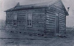 Location of Moore, Utah
Coordinates: 38°58′10″N 111°09′33″W / 38.96944°N 111.15917°W Country  United States
State  Utah
UtahCounty Emery Settled c. 1895 Named for L. C. Moore Area – Total 1.3 sq mi (3.4 km2) – Land 1.3 sq mi (3.4 km2) – Water 0.0 sq mi (0.0 km2) Elevation 6,247 ft (1,904 m) Population (2000) – Total 5 – Density 5/sq mi (5/km2) Time zone Mountain (MST) (UTC-7) – Summer (DST) MDT (UTC-6) ZIP code 84522 Area code(s) 435 FIPS code 49-56860[1] GNIS feature ID 1442870[2] Moore is an unincorporated community in west central Emery County, Utah, United States, at the edge of the San Rafael Swell. Moore is a community or populated place (Class Code U6) located in Emery County at latitude 38.967 and longitude -111.154. The elevation is 6,247 feet. Moore appears on the Emery East U.S. Geological Survey Map. The village is at the junction of County Routes County Road 801 and County Road 803 (known as the Moore Cut-off). The population was 5 at the 2000 census.
Historical populations Census Pop. %± 1930 114 — 1940 47 −58.8% 1950 41 −12.8% 2000 5 — Source: U.S. Census Bureau[3] Originally named Rochester for the hometown in New York of M. B. Whitney who was involved in the development of the area. About the same time Emery was digging the Muddy Canal, financial investors from the Eastern States became aware of the lush, productive farmland on the flats east of the Muddy River headwaters.[4] The investors saw the potential and formed The Independent Canal Company to claim water from the Muddy Creek and coax this arid land into producing grain like in the Midwest.[5]
Shares were offered to residents of Emery County, who also caught their vision. They began digging and blasting to build a new canal that would irrigate farmland and provide water. The town had a store, brick school, and post office.[5]
In 1940 the community was renamed Moore after postmaster L. C. Moore who became the land development project leader for the area in 1907,[6] when all of the Eastern investors had pulled out of the company.[4] Only a few residents still live in Moore. Most residents have moved into neighboring towns but have kept their farmland which continues to produce great crops.[5]
 Rochester Rock Art Panel
These pioneer settlements of the late 19th century were also the crossroads for other historic civilizations, such as the Fremont culture. Emery County was an important center for the Fremont Culture which dates back to about 700 to 1000. The later Bull Creek phase (1000–1200) seems to have developed during a wet cycle that allowed for more extensive agriculture and larger dwelling groups.[5] Several rock art panels surround Moore, such as the Rochester Rock Art Panel.
References
- ^ "American FactFinder". United States Census Bureau. http://factfinder.census.gov. Retrieved 2008-01-31.
- ^ "US Board on Geographic Names". United States Geological Survey. 2007-10-25. http://geonames.usgs.gov. Retrieved 2008-01-31.
- ^ "Census of Population and Housing". U.S. Census Bureau. http://www.census.gov/prod/www/abs/decennial/. Retrieved November 7, 2011.
- ^ a b "A Bridge to the Past-the History Of the Muddy Creek Bridge, Emery and Moore". Emery County Progress. 18 March 2008. http://www.ecprogress.com/index.php?tier=1&article_id=6162. Retrieved 19 October 2009.
- ^ a b c d Geary, Edward A (January 1996). A History of Emery County. Utah Centennial County History Series. Salt Lake City, Utah: Utah State Historical Society. ISBN 0-913738-05-0.
- ^ Origins of Utah Place Names p.32, 1941
Municipalities and communities of Emery County, Utah Cities 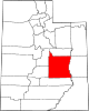
Towns Unincorporated
communityMoore
Indian
reservationGhost towns Connellsville | Desert Lake | Mohrland | Victor | Woodside
Categories:- Populated places in Emery County, Utah
- Populated places established in 1895
- Unincorporated communities in Utah


Wikimedia Foundation. 2010.