- Mookgophong Local Municipality
-
Mookgophong Local Municipality — Local municipality — Location in Limpopo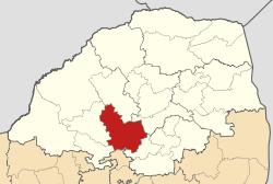
Coordinates: 24°40′S 29°0′E / 24.667°S 29°ECoordinates: 24°40′S 29°0′E / 24.667°S 29°E Country South Africa Province Limpopo District Waterberg District Seat Mookgophong Area - Total 4,271 km2 (1,649 sq mi) Population (2007)[1] - Total 16,818 - Density 3.9/km2 (10.2/sq mi) - Households 7,674 Racial makeup[2] (2007) - Black African 78.02% - White 21.27% - Coloured 0.12% - Indian or Asian 0.58% Time zone SAST (UTC+2) Municipal code LIM364 Mookgophong Local Municipality is located in the Waterberg District Municipality of Limpopo province, South Africa. The seat of Mookgophong Local Municipality is Mookgophong.
The Municiplity is named after the type of tree found in the area, Mokgopa (Cactus).[3]
References
- ^ "Community Survey, 2007: Basic Results Municipalities" (PDF). Statistics South Africa. http://www.statssa.gov.za/Publications/P03011/P030112007.pdf. Retrieved 2009-10-20.
- ^ "Community Survey 2007 interactive data". Statistics South Africa. http://www.statssa.gov.za/community_new/content.asp?link=interactivedata.asp. Retrieved 19 October 2009.
- ^ South African Languages - Place names
External links
Province of Limpopo, South Africa Provincial Capital: Polokwane District
and Local
MunicipalitiesCategories:- Local municipalities of Waterberg

Wikimedia Foundation. 2010.