- Montrose, Houston
-
For the larger area colloquially referred to as "Montrose", see Neartown Houston.For the management district, see Montrose District, Houston.
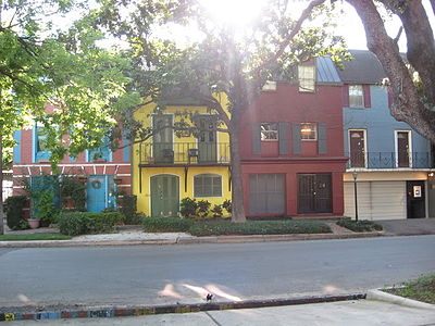
Montrose is a residential neighborhood located in the Neartown area of Houston, Texas, USA.[1][2] Established in 1911, the neighborhood is a demographically diverse area with renovated mansions, bungalows with wide porches, and cottages located along tree-lined boulevards. Montrose is one of the more pedestrian-friendly neighborhoods in Houston.
Contents
History
The area of what is Montrose today was originally envisioned as a planned community and streetcar suburb dating back to the early 20th century before the development of River Oaks. Developer J. W. Link and his Houston Land Corporation envisioned a "great residential addition" according to the neighborhood's original sales brochure. Link's planning details for the area included four wide boulevards with the best curbing and extensive landscaping. Link built his own home in Montrose, known as the Link-Lee Mansion, which is now part of the University of St. Thomas campus.[3] A streetcar, the Montrose Line, ran through the neighborhood. In the brochure, Link wrote what now seems like a huge understatement: "Houston has to grow. Montrose is going to lead the procession." It did, and the procession eventually continued far beyond the neighborhood.[3] Montrose was first platted in 1911.[4]
In 1926, the Plaza Apartment Hotel, Houston’s first apartment hotel, opened on Montrose Boulevard. The hotel was home to many of Houston’s leaders, including Dr. Edgar Odell Lovett, the first president of Rice University. Modeled after the Ritz-Carlton in New York, the hotel cost over one million dollars to construct.[5]
During the 1960s and 1970s, Neartown was known for its Bohemian flavor—this would spawn both the Westheimer Colony Art Festival in 1971 and the subsequent street fair in 1973, which would become known as the Westheimer Street Festival. KPFT Pacifica opened up in 1970, providing a radio station that catered to the political and cultural counterculture in the region. Also starting around the 1970s the area became known as the center for the gay and lesbian community of Houston.[citation needed]. Folk music clubs like Anderson Fair and and Sand Mountain catered to the folk scene in the neighborhood. Later, punk and new wave clubs like The Paradise Rock Island, the Omni, and Numbers opened up in the late 1970s and early 1980s.
During the 1990s through to recent times, this area has become increasingly gentrified with a trend towards remodeled and new homes, high rents, upmarket boutiques and restaurants. Neartown has become an eclectic niche market for office buildings in Houston, with both new development and redeveloped older buildings dotting Montrose Boulevard.[citation needed]
In 2009 the American Planning Association named Montrose as one of the ten "great neighborhoods" in the United States.[6]
Culture
Montrose hosts a number of communities including artists, musicians, and LGBTs, and has thrift, vintage, and second-hand shopping stores, gay bars, and restaurants. Anderson Fair is one of the oldest folk and original music venues in continuous operation in the United States.[7]
On Montrose Boulevard and Westheimer Road, there are a few original homes remaining—a majority have been converted to businesses and/or restaurants since 1936. Many examples of Houston's historic residential architecture can be found in the tree-lined streets off Montrose and Westheimer where many century-old bungalows and mansions can be found.
LGBT culture
According to Ray Hill, a 70-year old LGBT activist and Montrose resident quoted in the Houston Press, prior to 1970s the city's gay bars were spread around Downtown Houston and what is now Midtown Houston. Homosexual people needed to have a place to socialize after the closing of the gay bars. They began going to Art Wren, a 24 hour restaurant in Montrose. Around the time Montrose mainly included empty nesters and widows. Hill said that the homosexuals became attracted to Montrose as a neighborhood after encountering it while patronizing Art Wren, and they began to gentrify the neighborhood and assist the widows with the maintenance of their houses. Within Montrose new gay bars began to appear.[8] According to Hill, by 1985, as stated by Mandy Oaklander of the Houston Press, "the flavor and politics of the neighborhood were distinctly rainbow."[9] At the time 19% of the residents of Montrose were homosexual. In the late 1980s, AIDS affected many Montrose residents. Some area residents stopped patronizing restaurants in Montrose, believing that they would acquire AIDS from homosexual waiters. Some area funeral homes did not want to accept the bodies of men who died from AIDS. Oaklander said "[a]s AIDS tore through the neighborhood, the gay community flocked to the nightclubs for a reprieve from sickness and death."[9] The Murder of Paul Broussard occurred in Montrose in 1991.[9] By 2011 many homosexual people moved to the Houston Heights and to suburbs in Greater Houston, and less than 8% of Montrose's population was gay. Hill said that the decentralizing of Houston's homosexual population and the increasing acceptance of homosexuality in society caused business at gay bars in Montrose to decline.[10]
Notable residents
The former home of Howard Hughes on Yoakum Street is now part of the University of St. Thomas. East of Montrose Boulevard on Westmoreland Ave. is the Waldo Mansion, known as the oldest occupied house in Houston. Lyndon Johnson lived on Hawthorne Street when he taught high school in the 1930s.[11]
The Mansion (pictured right) of Ross S. Sterling, originally located in Downtown Houston, was moved into the Neighborhood.
Daniel Quinn, author of Ishmael and other books, lives and works in Montrose.[12]
Museums
The Museum of Fine Arts, Houston and the Contemporary Arts Museum Houston are located in southern Montrose.[13] The Menil Collection, on Sul Ross Street between Alabama Street and Richmond Avenue, is a free museum founded by John and Dominique de Menil, Houston philanthropists.[14]
Chapel
The Rothko Chapel is a non-denominational chapel located one block from The Menil Museum. Both were founded by John and Dominique de Menil. Fourteen black and color-hued paintings by Mark Rothko are on the interior walls. The shape and design of the chapel were largely influenced by the artist.
Infrastructure and government
Local government
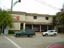
The community is within the Houston Police Department's Central Patrol Division,[15] headquartered at 61 Riesner.[16] The Neartown Storefront Station is located at 802 Westheimer Road.[16] The City of Houston purchased the building used for the storefront with federal community development funds. By September 20, 1990 the Neartown Business Alliance spent around $4,000 per year to maintain the storefront.[17]
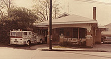
Houston Fire Department Fire Station 16 serves the area. The fire station is in Fire District 6.[18] The station opened at the intersection of Westheimer Road and Yupon in 1928. The station moved to the intersection of Richmond and Dunlavy in 1979.[19]
Montrose is within Houston City Council District C. Because of the inclusion of Montrose, the Houston Heights, and the Rice University area, it has the nickname "Hipstrict" for what Chris Moran of the Houston Chronicle refers to as its "progressive, urban ethic."[20] Previously Montrose was wholly within City Council District D.[21] 20 years before 2011, Montrose was moved from District C to district D to avoid putting too many minorities in a single city council district.[22] While Montrose was in District D, it was not able to have its own residents elected to city council. Instead the district was forced to try to influence electoral contests involving candidates from other neighborhoods.[23] As 2011 city council redistricting approached, some members of Houston's gay community and some Houston area bloggers proposed returning Montrose to District C.[22] Around 2011 an earlier plan would have combined the Heights and Montrose under a district called District J.[24]
It is also home to Mayor Annise Parker. Parker, a longtime resident of Montrose, started her political career by representing Montrose as an at-large city council member.[23] It is also home to At-Large Council Members Sue Lovell and Stephen Costello.[citation needed]
County, state, and federal representation
Harris County Precinct One, as of 2008 headed by El Franco Lee, serves Neartown. The county operates the Neartown Office at 1413 Westheimer Road.[25]
Montrose is located in Districts 134 and 147 of the Texas House of Representatives. Sarah Davis represents the portion of the neighborhood west of Montrose Boulevard,[26] and Garnet Coleman represents the portion of the neighborhood east of Montrose Boulevard.[27] Montrose is located in District 13 of the Texas Senate.[28] Rodney Ellis represents the district.
The community is within Texas's 7th congressional district.[29] As of 2008 the representative is John Culberson. The United States Postal Service operates the University Station at 1319 Richmond Avenue, adjacent to Montrose.[2][30]
City of Houston Designated Historic Districts
As of February, 2009, The Montrose was home to five of the twelve designated Historic Districts in the city of Houston. [2]. These are Audubon Place, [3] Avondale East,[4] Avondale West,[5] Courtland Place,[6] and Westmoreland [7].
Past elections
In a 1989 Houston Chronicle article Alan Bernstein described political support for Jim Westmoreland, an incumbent in an at-large position, in Montrose as "relatively weak." In one precinct 35.2 percent of the voting residents voted for him. Westmoreland drew controversy after reports of a joke that was characterized as "racist" spread. Beverley Clark, the opponent and a Black teacher, defeated Westmoreland in that race. Bernstein said that the significant racial minority groups and the "social tolerance" trait may have contributed to backlash against Westmoreland. Sarah Brunon, a Montrose resident and the president of the Neartown Association, said in a 1989 Houston Chronicle article that the "general comments" she heard after the Westmoreland remark was circulated throughout the press were "people's sense of amazement that someone would make such a remark such as that, even joking, in this day and age." Brunon added that Westmoreland did not often associate with the Neartown Association, unlike other at-large council members like Eleanor Tinsley, so many association members had little context in which to reference Westmoreland's remark.[31]
Montrose held the core of Mayor of Houston Kathy Whitmire's political support in the late 1970s and early 1980s. Montrose was the only area where a plurality of residents (40%) voted for her in the 1991 Mayor of Houston election.[32] Montrose provided political support for former city councilperson and now mayor Annise Parker.
Consulates
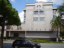
The Consulate-General of the People's Republic of China in Houston is at 3417 Montrose Boulevard in Montrose.[33]
Parks and recreation
The Houston Greek Festival is a major event that is held at the Annunciation Greek Orthodox Cathedral complex at 3511 Yoakum Boulevard, usually on the first week of October. The festival has been there for over four decades and is a popular event in the city.[34]
The Montrose Crawl is a pub crawl that takes place along Westheimer Road in Montrose on the last Saturday in October. A portion of all beverage sales made during the crawl are donated to charity.[35]
Ervan Chew Park, located at 4502 Dunlavy, is a Montrose neighborhood park that allows dogs off-leash in a designated area. [8]
In 2011 the Montrose Remembrance Garden, a memorial to victims of violent crimes, was established on vacant land owned by Charles Armstrong, an area club owner, at the intersection of California and Grant streets. The family of murder victim Aaron Scheerhoorn spearheaded the establishment of the park.[36]
Education
Colleges and universities
Montrose is home to the University of St. Thomas.
Montrose is also in close proximity to Rice University, The University of Texas Health Science Center at Houston, the University of Houston, Texas Southern University, Houston Community College Central, and University of Houston–Downtown.
Primary and secondary education
Public schools
Pupils in Montrose are zoned to Houston Independent School District schools.[2] Montrose is in Trustee District VIII, represented by Diana Dávila as of 2008.[37]
MacGregor Elementary School,[38] Poe Elementary School,[39] Wharton Elementary School,[40] and Wilson Elementary School serve separate sections of Montrose.[41]
Pupils in Montrose are divided between two separate middle school attendance boundaries. Lanier Middle School and Gregory-Lincoln Education Center serve separate sections of Neartown for middle school.[42][43] All Montrose pupils are zoned to Lamar High School.[44] High School for the Performing and Visual Arts, a magnet high school, is in Montrose.
For a period, Montrose Elementary School was formerly in Montrose.[45] Southmore Elementary School opened in 1921, Wilson in 1925, Lanier in 1926, Poe in 1928, and Wharton in 1929. Southmore was renamed MacGregor Elementary School in 1930 and Lamar opened in 1937. Gregory-Lincoln opened in 1966, and Gregory-Lincoln's current facility opened in 2007.[46]
Private schools
The area also houses the Annunciation Orthodox School (a K-8 private school). And Presbyterian School (2yr- 8th a private school).
The Kinkaid School was located in the Neartown area until 1957 when the school moved to Piney Point Village.[47]
Gallery of private schools
The Eleanor K. Freed Montrose Library of the Houston Public Library
Public libraries
The Eleanor K. Freed-Montrose Neighborhood Library of Houston Public Library is at 4100 Montrose Boulevard, and was donated to the City of Houston for use as a library in 1986 by the then owner, John Hansen Investment Builder.[48] The library is housed in a former church and is located near a bakery and the Black Labrador Pub. There is a concrete block set into the wall of the building that reads Central Church of Christ, 1946. The bell tower or campanile is located by the front door of the library although the bell is gone, and there is a small colonnade connecting the main church-library building to former church meeting rooms and offices. Facing Montrose Boulevard, the original stained glass window of the church can be seen featuring a dove with an olive branch in its beak. A modern office building complex in the surrounding area is known as The Campanile, named after the bell tower in the library. The Houston Press ranked the library the best public library branch in Houston in 2009. The Houston Press said that there was "something so urban and civilized about the Montrose branch" and that the library was "a great place for parents and kids, as the branch hosts a multitude of child-friendly events each week."[49]
Notable residents
- Annise Parker (Mayor of Houston, former at-large Houston City Council member)[23]
External links
References
- ^ Map of Neartown. Neartown Association. Retrieved October 20, 2008.
- ^ a b c Map of Montrose. Houston Chronicle. Retrieved October 20, 2008.
- ^ a b "In Montrose, Houston First Went Boom, Kathryn Jones (March 24, 2002)". nytimes.com. March 24, 2002. http://query.nytimes.com/gst/fullpage.html?sec=travel&res=950DE3D91438F937A15750C0A9649C8B63. Retrieved 2007-06-02.
- ^ "About the Neartown Association." Neartown Association. September 29, 2007.
- ^ "The Plaza Apartment Hotel". historichouston.org. Archived from the original on 2007-09-30. http://web.archive.org/web/20070930122533/http://www.historichouston.org/newSite/landmarks/VIRTUAL/plazaHistory.htm. Retrieved 2007-06-02.
- ^ Connelly, Richard. "Montrose Is One Great Neighborhood, Experts Say, Despite The Things That Are Gone." Houston Press. Wednesday October 7, 2009. Retrieved on October 8, 2009.
- ^ "Anderson Fair (One fan's historical perspective), Karl A. Cailllouet (1996)". andersonfair.com. http://www.andersonfair.com/HssAF_2.htm. Retrieved 2007-06-02.
- ^ Oaklander, Mandy. "The Mayor of Montrose." Houston Press. Wednesday May 18, 2011. 1. Retrieved on May 18, 2011.
- ^ a b c Oaklander, Mandy. "The Mayor of Montrose." Houston Press. Wednesday May 18, 2011. 2. Retrieved on May 18, 2011.
- ^ Oaklander, Mandy. "The Mayor of Montrose." Houston Press. Wednesday May 18, 2011. 4. Retrieved on May 18, 2011. '"Gay bars used to be places where we had to go to get refuge because we were not welcome anywhere else," he says. "Well, guess what? There's nowhere we're not welcome anymore."'
- ^ "Houston: A city without zoning, Sherry Thomas (October 07, 2003)". usatoday.com. http://www.usatoday.com/travel/destinations/cityguides/houston/2003-10-07-spotlight-zoning_x.htm. Retrieved 2007-06-02.
- ^ "New Tribal Ventures - Who Are We?". newtribalventures.com. http://www.newtribalventures.com/ntv/whoarewe/moreinfo.cfm. Retrieved 2009-05-10.[dead link]
- ^ "MUSEUM OF FINE ARTS, HOUSTON, Handbook of Texas Online, Kendall Curlee". tshaonline.org. http://www.tshaonline.org/handbook/online/articles/MM/klm4.html. Retrieved 2007-06-02.
- ^ "MENIL COLLECTION, Handbook of Texas Online, Linda Peterson". tshaonline.org. http://www.tshaonline.org/handbook/online/articles/MM/klm6.html. Retrieved 2007-06-02.
- ^ "Crime Statistics for Central Patrol Division." City of Houston. Retrieved May 23, 2008.
- ^ a b "Volunteer Initiatives Program, Citizens Offering Police Support." City of Houston. Retrieved May 23, 2008.
- ^ "`Storefront' police station funding debated." Houston Chronicle. Accessed April 16, 2008.
- ^ "Fire Stations." City of Houston. Retrieved December 11, 2008.
- ^ "Fire Station 16." City of Houston. Retrieved on April 3, 2010.
- ^ Moran, Chris. "Only 2 city incumbents lack opponents." Houston Chronicle. Thursday September 8, 2011. Retrieved on November 5, 2011.
- ^ "[1]." District D Homepage
- ^ a b "Jigsaw puzzle: Creating two new Houston City Council seats poses demographic challenges." (editorial) Houston Chronicle. Wednesday January 26, 2011. Retrieved on November 5, 2011.
- ^ a b c "Political challenge: Revised council redistricting plan offers Hispanics a third majority district." (editorial) Houston Chronicle. Wednesday May 18, 2011. Retrieved on November 5, 2011.
- ^ Connelly, Richard. "City Council Redistricting Map: Montrose and the Heights, (Somewhat) Together." Houston Press. April 6, 2011. Retrieved on November 5, 2011.
- ^ "Office Locations." Harris County Precinct One. Accessed October 13, 2008.
- ^ "Map of Texas House District 134." Texas House of Representatives. Accessed June 9, 2010.
- ^ "Map of Texas House District 147." Texas House of Representatives. Accessed June 9, 2010.
- ^ "Senate District 13" Map. Senate of Texas. Accessed September 28, 2008.
- ^ "Congressional District 7." National Atlas of the United States. Retrieved May 23, 2008.
- ^ "Post Office Location - UNIVERSITY." United States Postal Service. Retrieved on December 11, 2008.
- ^ Bernstein, Alan. "Core of white support failed to halt Westmoreland's defeat." Houston Chronicle. Sunday November 12, 1989. A1.
- ^ Bernstein, Alan and Jim Simmon. "Black vote went solidly for Turner/Whitmire failed to produce split." Houston Chronicle. Thursday November 7, 1991. A21. "The only area where Whitmire ran first Tuesday was in Montrose, which provided the core of her political base in the late 1970s and early '80s. And even in those precincts she managed to garner only about 40 percent, with Turner and Lanier splitting the rest."
- ^ Home. Consulate-General of the People's Republic of China in Houston. Retrieved on January 10, 2009.
- ^ "The Original Greek Festival, Houston, Texas". greekfestival.org. http://www.greekfestival.org/when.html. Retrieved 2007-06-02.
- ^ "The Montrose Crawl". montrosecrawl.com. http://www.montrosecrawl.com/about-the-montrose-crawl. Retrieved 2008-11-26.
- ^ Mathis, Lauren. "Montrose garden helps plant seeds of change against violence." Houston Chronicle. August 6, 2011. Retrieved on August 6, 2011.
- ^ "Trustee Districts Map." Houston Independent School District. Retrieved on November 11, 2008.
- ^ "MacGregor Elementary School Attendance Boundary," Houston Independent School District. Retrieved October 20, 2008.
- ^ "Poe Elementary School Attendance Boundary," Houston Independent School District. Retrieved October 20, 2008.
- ^ "Wharton Elementary School Attendance Boundary," Houston Independent School District. Retrieved October 20, 2008.
- ^ "Wilson Elementary School Attendance Boundary," Houston Independent School District. Retrieved October 20, 2008.
- ^ "Gregory-Lincoln Middle School Attendance Boundary," Houston Independent School District. Retrieved October 20, 2008.
- ^ "Lanier Middle School Attendance Boundary," Houston Independent School District. Retrieved October 20, 2008.
- ^ "Lamar High School Attendance Boundary," Houston Independent School District. Retrieved October 20, 2008.
- ^ The National Elementary Principal, Volume 51. National Association of Elementary School Principals, 1945. Page 326. Digitized by Google Books on October 27, 2008. Retrieved on January 1, 2010. "Montrose Elementary School, 4011 Stanford, Houston."
- ^ "School Histories: the Stories Behind the Names." Houston Independent School District. Accessed September 24, 2008.
- ^ Kinkaid School from the Handbook of Texas Online
- ^ "Freed-Montrose Neighborhood Library." Houston Public Library. Retrieved on December 11, 2008.
- ^ "Freed-Montrose Library." Houston Press. Retrieved on March 11, 2010.
See also
 City of Houston
Nickname: Space City Topics History | Geography | Climate | Politics | Mayors | Economy | Demographics | Culture | Architecture | Transportation | Education | Nicknames | Sister cities
Attractions Theater District | Bayou Place | Museum District | Houston Zoo | Hermann Park | Space Center Houston | the Galleria | Waterwall Park | Memorial Park | Discovery Green | Lee and Joe Jamail Skatepark | University of Houston
Business Districts Downtown | Uptown | Texas Medical Center | Greenway Plaza | Energy Corridor | Westchase | Memorial City | Greenspoint
See also: List of companies in HoustonCommunities Acres Homes | Addicks | Alief | Almeda | Bordersville | Boulevard Oaks | Braeburn | Braeswood Place | Brays Oaks | Blue Ridge | Chinatown | Clear Lake City | Denver Harbor | East Downtown | East End | East Houston | Genoa | Glenbrook Valley | Greater Sharpstown | Gulfton | Harrisburg | Hiram Clarke | Houston Heights | Independence Heights | Inwood Forest | Kingwood | Magnolia Park | Maplewood | Meyerland | Midtown | Montrose District | Museum District | Neartown | Near Northwest | North Shore | Northside | Oak Forest | River Oaks | Riverside Terrace | South Park | Spring Branch | Sunnyside | Upper Kirby
Historic wards: First Ward | Second Ward | Third Ward | Fourth Ward | Fifth Ward | Sixth Ward
See also: The six wards of HoustonNeighborhoods Afton Oaks | Brentwood | Briargrove Park | City Park | Clinton Park | Cloverland | Corinthian Pointe | Crestwood | Eastwood | Garden Oaks | Highland Village | Houston Gardens | Idylwood | Kashmere Gardens | Larchmont | Magnolia Grove | Montrose | Morningside Place | Near North Side | Nottingham Forest | Old Braeswood | Pecan Park | Port Houston | Rice Military | Robindell | Royal Oaks Country Club | Settegast | Sharpstown | Shenandoah | University Oaks | Walnut Bend | Westbury | West End | Westmoreland | Willow Meadows | Willowbend | Woodland Heights
See: List of Houston neighborhoodsEducation Public universities: University of Houston | University of Houston–Clear Lake | University of Houston–Downtown | Texas Southern University
Private universities: Rice University | Houston Baptist University | University of St. Thomas
Community colleges: Houston Community College | Lone Star College | San Jacinto College
See: List of colleges and universities in HoustonCategories:- Gay villages in Texas
- Neighborhoods in Houston, Texas
- Streetcar suburbs
- Gay villages in the United States
Wikimedia Foundation. 2010.


