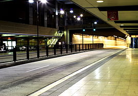
Mater Hill busway station
- Mater Hill busway station
-
| Mater Hill |
 |
| Station statistics |
| Address |
Water St, South Brisbane |
| Lines |
South East Busway |
| Platforms |
2 |
| Other information |
| Accessible |
 |
| Owned by |
TransLink |
| Fare zone |
1/2 |
| Services |
| Preceding station |
|
Translink |
|
Following station |
|
South Bank
|
|
South East Busway |
|
Woolloongabba
Terminus
|
|
South East Busway |
|
Buranda
toward Springwood
|
|
Mater Hill Busway Station, at South Brisbane, an inner-south suburb in Brisbane, the state capital of Queensland, Australia. It is part of the South East Busway serviced by TransLink.
Mater Hill Busway Station is close to the Mater Private Hospital – Brisbane and the South Bank Parklands. Mater Hill is located on the zone boundary between zones 1 & 2 of the TransLink integrated public transport system. Mater Hill Busway Station is the main route change busway station.
External links
For an informal but complete listing of TransLink bus routes, see the following list of TransLink services. For accurate bus timetables and route maps, see the TransLink Bus Services website.
| v · Cultural Centre • South Bank • Mater Hill • Woolloongabba • Buranda • Greenslopes • Holland Park West • Griffith University • Upper Mount Gravatt • Eight Mile Plains • Rochedale (proposed) • Springwood
|
|
Coordinates: 27°29′05.30″S 153°01′38.93″E / 27.484806°S 153.0274806°E / -27.484806; 153.0274806
Categories:
- Bus stations in Brisbane
- Australian building and structure stubs
- Bus station stubs
Wikimedia Foundation.
2010.
Look at other dictionaries:
Mater Hill Busway Station, Brisbane — TL Bus Station station name=Mater Hill region=Brisbane Central suburb=South Brisbane zone=1/2 stands=2 routes=40 trainconnect=no pnr=no phones=yes toilets=nearest at Mater Hospital) disabled=yes busway1=South East IB1=South Bank OB1=Woolloongabba … Wikipedia
Cultural Centre busway station — Cultural Centre Station statistics Address Melbourne Street, South Brisbane Coordinates … Wikipedia
Woolloongabba Busway Station, Brisbane — TL Bus Station station name=Woolloongabba region=Brisbane East suburb=Woolloongabba zone=2 stands=2 routes=23 trainconnect=no pnr=no phones=yes toilets=no disabled=yes busway1=South East IB1=Mater HillThe Woolloongabba Busway Station is part of… … Wikipedia
Buranda Busway Station, Brisbane — TL Bus Station station name=Buranda region=Brisbane South suburb=Buranda zone=2 stands=2 routes=43 trainconnect=yes, at Buranda railway station pnr=no phones=yes toilets=yes, at Buranda railway station disabled=yes busway1=South East IB1=Mater… … Wikipedia
South Bank Busway Station, Brisbane — TL Bus Station station name=South Bank region=Brisbane Central suburb=South Brisbane zone=1 stands=2 routes=many trainconnect=yes, at South Bank station pnr=no phones=yes toilets=yes, at South Bank Parklands disabled=yes busway1=South East… … Wikipedia
Chermside bus station — Station statistics Address Gympie and Hamilton Roads, Chermside Coordinates … Wikipedia
Noosa Heads bus station — Noosa Heads … Wikipedia
River Plaza Ferry Wharf, Brisbane — Brisbaneferries Wharf wharf name=River Plaza image region=Brisbane Central servicearea1=Inner City Ferry US1=South Bank 3 DS1=Thornton Street suburb=South Brisbane street=Lower River Terrace zone=1 berths=1 busconnect=yes trainconnect=no pnr=no… … Wikipedia
Brisbane — This article is about the Australian metropolis. For the local government area, see City of Brisbane. For other uses, see Brisbane (disambiguation). Brisbane Queensland … Wikipedia
List of South East Queensland bus stations — The following is a list of bus and busway stations which have been built or are under construction in and around Brisbane and South East Queensland, Australia.Busway stations in Brisbane =Boggo Road Busway (proposed) = *University of Queensland… … Wikipedia


