- Mammamattawa, Ontario
-
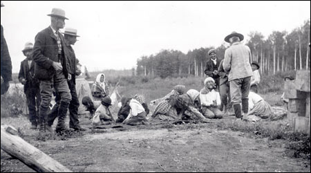
Mammamattawa Settlement 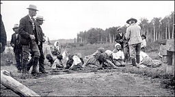 Indians at English River Post, 1905
Country Canada Province Ontario Region Northeastern Ontario District Cochrane Part Cochrane, Unorganized, North Elevation 91 m (299 ft) Coordinates 50°24′47″N 84°22′04″W / 50.41306°N 84.36778°W Timezone Eastern Time Zone (UTC-5) - summer (DST) Eastern Time Zone (UTC-4) Postal code FSA P0L Area code 705, 249 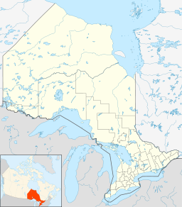
 Location of Mammamattawa in Ontario
Mammamattawa is an unincorporated place and community in the Unorganized North Part of Cochrane District in northeastern Ontario, Canada.[1][2] It is located at the confluence of the Kenogami River with the Kabinakagami River, and just 2 kilometres downstream of the mouth of the Nagagami River, in the James Bay drainage basin.[3]
The Constance Lake First Nation operates a camp at Mammamattawa.[4]
History
The first inland post of the Hudson's Bay Company, named Henley House, was established at the confluence of the Kenogami River and Albany River in 1743.[5][6] A new post was established in 1884 at the confluence of the Kenogami River and the Kabinakagami River.[7] It was known as the English River Post, as the Kenogami was also known as the English River.[8] The English River First Nation, the primary forerunner to today's Constance Lake First Nation, had a reserve set aside for their use just north of the post in 1912, which remains part of the Constance Lake First Nations lands as English River 66 Indian Reserve.[9][3] The Hudson's Bay Company English River Post was abandoned in 1941, and the place later took on its present First Nations name.
References
- ^ "Mammamattawa". Geographical Names Data Base. Natural Resources Canada. http://geonames.nrcan.gc.ca/search/unique_e.php?id=FCDIE&output=xml. Retrieved 2011-08-18.
- ^ Ministry of Transportation of Ontario (2010-01-01) (PDF). Map 14 (Map). 1 : 1,600,000. Official road map of Ontario. http://www.mto.gov.on.ca/english/traveller/map/images/pdf/northont/sheets/Map14.pdf. Retrieved 2011-08-21.
- ^ a b "English River Post" (PDF). Geology Ontario - Historic Claim Maps. Ontario Ministry of Northern Development, Mines and Forestry. http://www.geologyontario.mndmf.gov.on.ca/website/historic_claim_maps/E/English%20River%20Post.pdf. Retrieved 2011-08-24.
- ^ "Mammamattawa Camp". Constance Lake First Nation. 2010. http://www.clfn.on.ca/default.asp?pgid=40. Retrieved 2011-08-20.
- ^ Kudelik, Gail. "Albany River". The Canadian Encyclopedia. The Historica Dominion Institute. http://thecanadianencyclopedia.com/index.cfm?PgNm=TCE&Params=A1ARTA0000112. Retrieved 2011-08-19.
- ^ "B.71 (Fly Lake) to B.88 (Hulse House) - Henley House". Hudson's Bay Company Archives. Archives of Manitoba. http://www.gov.mb.ca/chc/archives/hbca/resource/post_rec/post5.html#86. Retrieved 2011-08-19.
- ^ "B. 371 (Beaver Lake Portage) to B.395 (Bucke) - English River Post". Hudson's Bay Company Archives. Archives of Manitoba. http://www.gov.mb.ca/chc/archives/hbca/resource/post_rec/post26.html#375. Retrieved 2011-08-19.
- ^ "Our History". Constance Lake First Nation. 2010. http://www.clfn.on.ca/default.asp?pgid=6. Retrieved 2011-08-20.
- ^ "English River 66". Geographical Names Data Base. Natural Resources Canada. http://geonames.nrcan.gc.ca/search/unique_e.php?id=FESYL&output=xml. Retrieved 2011-08-20.
Categories:- Communities in Cochrane District, Ontario
- Northern Ontario geography stubs

Wikimedia Foundation. 2010.