- Maluti-a-Phofung Local Municipality
-
Maluti-a-Phofung Local Municipality — Local municipality — Location in the Free State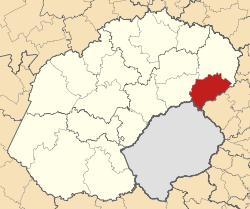
Country South Africa Province Free State District Thabo Mofutsanyana Seat Phuthaditjhaba Area - Total 4,418 km2 (1,705.8 sq mi) Population (2007)[1] - Total 385,413 - Density 87.2/km2 (225.9/sq mi) - Households 97,172 Racial makeup[2] (2007) - Black African 98.09% - White 1.68% - Coloured 0.09% - Indian or Asian 0.13% Time zone SAST (UTC+2) Municipal code FS194 Maluti-a-Phofung Local Municipality is an administrative area in the Thabo Mofutsanyane District of the Free State in South Africa. The municipality is named after the Drakensberg mountains (known as "Maluti" in Sesotho). The peak in Qwaqwa is known as the Sentinel, which is called "Phofung" in Sesotho.[3]
References
- ^ "Community Survey, 2007: Basic Results Municipalities" (PDF). Statistics South Africa. http://www.statssa.gov.za/Publications/P03011/P030112007.pdf. Retrieved 2009-10-20.
- ^ "Community Survey 2007 interactive data". Statistics South Africa. http://www.statssa.gov.za/community_new/content.asp?link=interactivedata.asp. Retrieved 19 October 2009.
- ^ South African Languages - Place names
Province of Free State, South Africa Provincial Capital: Bloemfontein Metropolitan
MunicipalityDistrict
and Local
MunicipalitiesThabo MofutsanyanaCategories:- Local Municipalities of Thabo Mofutsanyane

Wikimedia Foundation. 2010.