- Ravensbourne, New Zealand
-
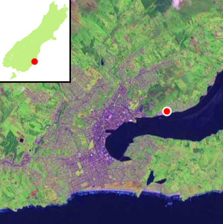
 Location of Ravensbourne (shown by red dot) within Dunedin. The railway causeways at Burkes can be clearly seen to the northeast.
Ravensbourne is a suburb of the New Zealand city of Dunedin. It is located on the steep southeastern slopes of Signal Hill above the Otago Harbour. It lies on the harbour's northern shore, 4.5 kilometres (2.8 mi) east-northeast of the city centre. Ravensbourne's 2001 population was 1,269.
Rail and road links between central Dunedin and Port Chalmers run through Ravensbourne on the narrow strip of land between the hill slopes and harbour. A cycleway also links the suburb with the main part of the city, which lies to the west on the far side of a bluff partly occupied by the Logan Point Quarry. One of the older harbourside suburbs, it has a distinct identity from the rest of the city's inner suburbs.
The suburb is mainly residential, but is dominated by two large industrial plants, the Logan Point Quarry and the Ravensdown Fertiliser factory, which is located at the harbour's edge at the southern end of the suburb. The Forsyth Barr Stadium at University Plaza is under construction to the south of Ravensbourne, close to the entrance to the quarry. Construction of this stadium will see alterations to the route between the suburb and central Dunedin.
Ravensbourne contains a significant number of smaller homes, quite a number of which are occupied as flats by students from the University of Otago and Otago Polytechnic, which lie 2 kilometres (1.2 mi) to the west. The suburb consists mainly of the Dunedin-Port Chalmers highway, State Highway 88, and numerous narrow winding roads which climb the hill to its northwest. Above the suburb is Burns Park Scenic Reserve, which occupies much of the upper slopes of Signal Hill.
The suburb, along with the nearby suburbs of Maia, Burkes, and Saint Leonards, are often collectively referred to as West Harbour. Under this name, the area was a separate borough for many years from 1877 until amalgamation with the city of Dunedin in 1963.
The suburb takes its name from the property of the first mayor of West Harbour, Thomas De Lacy, who was mayor from 1877 to 1878. The name was due to the profusion of weka in the area of De Lacy's property, whose cockiness reminded De Lacy of the ravens in his native Scotland. The Maori name for the area is Kaitaki Tamariki, though this is rarely used today.
The smaller settlements of Maia and Burkes lie on the coast of the harbour immediately to the northeast of Ravensbourne. Maia, basically a suburb of Ravensbourne, lies 1 kilometre (0.62 mi) to the northeast. Its name and the pronunciation of it mean that it is often mistaken for a Maori name, though it was actually named for the Greek mythological daughter of Atlas, one of the Pleiades.
Burkes lies to the northeast of Maia, and consists of one long narrow road running roughly parallel with and above the highway. The most notable feature of Burkes is that the South Island Main Trunk railway crosses a series of causeways spanning some of the small bays which run along the harbour's edge.
North of Burkes is the larger settlement of Saint Leonards, which was named by early settler David Carey for the English town of St Leonards-on-Sea, on the Sussex coast, which had been the birthplace of his wife.[1][2]
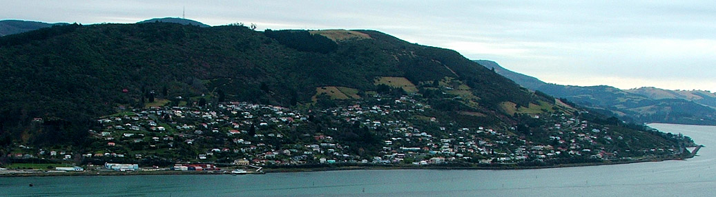
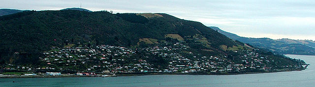 Ravensbourne and Maia are shown in this view from Shiel Hill on the southern side of Otago Harbour. One of the railway causeways at Burkes is visible at the far right. The television transmitter on the top of Mount Cargill is visible behind Signal Hill in the background.
References
- ^ Reed, A.W. (1975) Place names of New Zealand. Wellington: A.H. & A.W. Reed. ISBN 0-589-00933-8 p. 372
- ^ Wise's New Zealand guide: A gazeteer of New Zealand (4th ed.) (1969) Dunedin: H. Wise & Co. (N.Z.) Ltd. p. 309
Suburbs of Dunedin Central city Main urban area - north Balmacewen · Burkes · Dalmore · The Gardens · Glenleith · Leith Valley · Liberton · Maia · Maori Hill · Mount Mera · Normanby · North East Valley · Opoho · Pine Hill · Prospect Park · Ravensbourne · St Leonards · Wakari · WoodhaughMain urban area - east Main urban area - south Andersons Bay · Corstorphine · Forbury · Kensington · Kew · Musselburgh · Ocean Grove (Tomahawk) · St Clair · St Kilda · Shiel Hill · South Dunedin · Sunshine · Tahuna · TainuiMain urban area - west Abbotsford · Balaclava · Belleknowes · Bradford · Brockville · Burnside · Caversham · Calton Hill · Concord · Glenross · Green Island · Halfway Bush · Helensburgh · Kaikorai · Kaikorai Valley · Kenmure · Littlebourne · Lookout Point · Maryhill · Mornington · Roslyn · SunnyvaleSurrounding districts Aramoana · Brighton · Broad Bay · Careys Bay · Company Bay · Evansdale · Fairfield · Harington Point · Macandrew Bay · Mosgiel · Ocean View · Otakou · Port Chalmers · Portobello · Pukehiki · Roseneath · Sawyers Bay · Waitati · Waldronville · WingatuiCategories:- Suburbs of Dunedin
- Otago Region geography stubs
Wikimedia Foundation. 2010.