- Dunnerdale with Seathwaite
-
Coordinates: 54°21′18″N 3°11′17″W / 54.355°N 3.188°W
Dunnerdale with Seathwaite 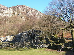
Hollin House Tongue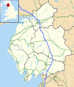
 Dunnerdale with Seathwaite
Dunnerdale with Seathwaite shown within CumbriaPopulation 129 (2001) OS grid reference SD2296 Parish Dunnerdale with Seathwaite District South Lakeland Shire county Cumbria Region North West Country England Sovereign state United Kingdom Post town BROUGHTON IN FURNESS Postcode district LA20 Dialling code 01229 Police Cumbria Fire Cumbria Ambulance North West EU Parliament North West England List of places: UK • England • Cumbria Dunnerdale with Seathwaite is a civil parish in the South Lakeland district of the English county of Cumbria. It includes the village of Seathwaite and the hamlets of Cockley Beck, Hall Dunnerdale and Hoses, and is located 6.2 miles (10.0 km) north of Broughton in Furness, 34.0 miles (54.7 km) west of Kendal and 57.3 miles (92.2 km) south of Carlisle. The parish has a population of 129.[1]
References
- ^ "Census 2001: Parish Headcounts: South Lakeland". Neighbourhood Statistics. Office for National Statistics. http://www.neighbourhood.statistics.gov.uk/dissemination/viewFullDataset.do?instanceSelection=03070&productId=779&$ph=60_61&datasetInstanceId=3070&startColumn=1&numberOfColumns=8&containerAreaId=790350. Retrieved 26 October 2010.
External links
- A Vision of Britain Through Time
- British History Online
- British Listed Buildings
- Genuki
- Geograph
- Office for National Statistics
Ceremonial county of Cumbria Boroughs or districts Major settlements - Alston
- Ambleside
- Appleby-in-Westmorland
- Aspatria
- Barrow-in-Furness
- Bowness-on-Windermere
- Brampton
- Broughton-in-Furness
- Carlisle
- Cleator Moor
- Cockermouth
- Dalton-in-Furness
- Egremont
- Grange-over-Sands
- Harrington
- Kendal
- Keswick
- Kirkby Lonsdale
- Kirkby Stephen
- Longtown
- Maryport
- Millom
- Penrith
- Sedbergh
- Silloth
- Ulverston
- Whitehaven
- Wigton
- Windermere
- Workington
See also: List of civil parishes in Cumbria
Topics Categories:- Cumbria geography stubs
- South Lakeland
- Civil parishes in Cumbria


Wikimedia Foundation. 2010.