- Dry Andes
-
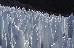
The Dry Andes is a climatic and glaciological subregion of the Andes. Together with the Wet Andes it is one of the two subregions of the Argentine and Chilean Andes. The Dry Andes runs from the Atacama Desert in northern Chile and Argentina south to a latitude of 35°S in Chile. In Argentina the Dry Andes reaches 40°S due to the leeward effect of the Andes. According to Luis Lliboutry the Dry Andes can be defined after the distribution of penitentes.[1] The southernmost well developed penitentes are found on Lanín Volcano.
References
- ^ "Glaciers of the Dry Andes". Louis Lliboutry, USGS. http://pubs.usgs.gov/pp/p1386i/chile-arg/dry/. Retrieved 2008-12-21.
Tropical Andes (11° N–20° S) Pico Bolívar · Pico Humboldt · Pico Bonpland · Nevado del Ruiz · Antisana · Cotopaxi · Chimborazo · Alpamayo · Huascaran · Sabancaya · Ampato · ChacaltayaDry Andes (20°–35° S) Wet Andes (35°–55° S) OtherGrosse · Exploradores · Reicher · Gualas · San Rafael · Fiero · Leon · San Quintín · Soler · Benito · Nef · Cachet · Colonia · SteffenJorge Montt · Bernardo · O'Higgins · Brüggen · Viedma · Upsala · Perito Moreno · Dickson · Grey · Amalia · Tyndall/GeikeNote: Glaciers are ordered by latitude from north to south. Mountains with significant glaciers are shown in italics.Categories:- Climate of Argentina
- Climate of Chile
- Glaciers of Chile
Wikimedia Foundation. 2010.

