- Dog Town, California
-
For the community in Amador County formerly with this name, see Bunker Hill, Amador County, California. For other uses, see Dogtown (disambiguation).
Dog Town — Ghost town — Site of Dog Town Location in California Coordinates: 38°10′13″N 119°11′51″W / 38.17028°N 119.1975°WCoordinates: 38°10′13″N 119°11′51″W / 38.17028°N 119.1975°W Country United States State California County Mono County Elevation[1] 7,057 ft (2,151 m) Reference #: 792 Dog Town (also, Dogtown[1] and Dogtown Diggings[2]) is a ghost town in Mono County, California.[1] It is located on Dog Creek about 6 miles (10 km) south-southeast of Bridgeport,[2] at an elevation of 7057 feet (2151 m).[1]
Today, Dog Town is a defunct gold rush era town in Mono County, California. It is located at 38°10′13″N 119°11′51″W / 38.1701984°N 119.1973749°W, on Dog Creek, near the junction of Clearwater and Virginia Creeks. The town was established in approximately 1857 by Carl Norst as a placer mining camp.[3] By 1859, a group of Mormons had arrived as miners at the site and a mining camp arose.[2] The name "Dogtown" was often applied by miners to camps where living conditions were miserable.[2] Dogtown survived briefly before being abandoned.
Dogtown was the first gold mining camp in the Eastern Sierra Nevada. Although its deposits were minimal, Dogtown did attract attention to the area as a whole, including the subsequent discoveries of much richer gold deposits in nearby areas such as Bodie, Aurora and Masonic.
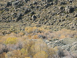
As of 2005[update], the surviving remnants of Dogtown are the walls of several stone huts, a few roof timbers, and a single gravesite. The ruins have been mildly vandalized.
The site is registered as California Historical Landmark 792. A landmark plaque by the side of nearby U.S. Highway 395 marks the location.
Gallery
References
- ^ a b c d U.S. Geological Survey Geographic Names Information System: Dog Town, California
- ^ a b c d Durham, David L. (1998). California's Geographic Names: A Gazetteer of Historic and Modern Names of the State. Quill Driver Books. p. 1160-1161. ISBN 9781884995149.
- ^ Gudde, Erwin. 1975. California Gold Camps. University of California Press: Berkeley. pp.97-98.
- ghosttowns.com discussion of Dogtown
- California Environmental Resources Evaluation System (CERES) Record
- Rand McNally The Road Atlas 2006: US, Canada, Mexico ISBN 0-528-95795-3
Municipalities and communities of Mono County, California County seat: Bridgeport Town CDPs Aspen Springs | Benton | Bridgeport | Chalfant | Coleville | Crowley Lake | June Lake | Lee Vining | McGee Creek | Mono City | Paradise | Sunny Slopes | Swall Meadows | Topaz | Walker
Unincorporated
communitiesBelfort | Benton Crossing | Benton Hot Springs | Chinatown | Crestview | Fales Hot Springs | Hammil | June Lake Junction | Lake Mary | Lower Town | Mesa Camp | Montgomery City | North Landing | Oasis | Pizona | Sonora Junction | South Landing | Toms Place | Upper Town | Wheeler Crest | Whitmore Hot Springs | Willow Springs
Indian
reservationsBenton Paiute Reservation | Bridgeport Paiute Indian Colony
Former
settlementsBennettville | Bodie | Dog Town | Dunderberg Mill | Lundy | Masonic | Mill City | Mono Mills | Mono Village | Monoville | State Line
Categories:- California Gold Rush
- California Historical Landmarks
- Former settlements in Mono County, California
- National Register of Historic Places in California
- Sierra Nevada (U.S.)
- Ghost towns in California
- Populated places established in 1857
- Sierra Nevada geography stubs
- California ghost town stubs
Wikimedia Foundation. 2010.


