- Diogo Ribeiro
-
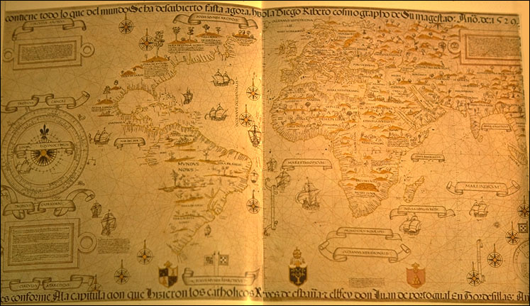
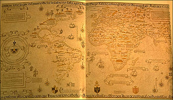 Worldmap by Diego Ribero, 1529
Diogo Ribeiro, also known as Diego Ribero, was a Portuguese cartographer and explorer who worked most of his life in Spain. He worked on the official maps of the Padron Real (or Padron General ) from 1518-1532. He also made navigation instruments, including astrolabes and quadrants.[1]
Contents
Early life
Born as Diogo Ribeiro, he was the son of Afonso Ribeiro and Beatriz de Oliveira.[1] However, there is no known record of the date and place of his birth. He is believed to have become a seaman at an early age and made several voyages to India as a ship pilot. Reportedly, Ribero sailed with Pedro Afonso de Aguiar who served as captain in the armadas of the explorers Vasco da Gama (1502), Lopo Soares (1504), and Afonso de Albuquerque (1509).[1]
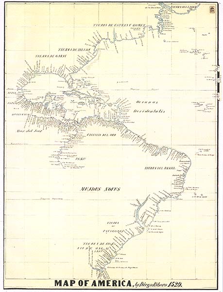
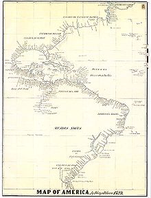 Detail of the American Coast from Diego Ribero's 1529 map
Career
Ribero started working for Charles V in 1518,[2] as a cartographer at the Casa de Contratación in Seville. He adopted Spanish citizenship in 1519, and took part in the development of the maps used in the First Circumnavigation of the Earth.
On January 10, 1523, he was named Royal Cosmographer and "master in the art of creating maps, astrolabes, and other instruments". He eventually succeeded Sebastian Cabot (who left on a voyage) as the head cartographer. Cabot published his first map in 1544.
In 1524, Ribero participated in the Spanish delegation at the Conference of Badajoz, where Spain and Portugal discussed whether the Philippines were on the Spanish or Portuguese side of the Treaty of Tordesillas.
In 1527, Ribero finished the Padrón Real, the official (and secret) Spanish map used as template for the maps present in all Spanish ships. It is considered the first scientific world map.
In 1531, he invented a bronze water pump that was able to pump water out ten times faster than the previous models.
Diego Ribero died in 1533.
First scientific world map
Ribero's most important work is the 1527 Padrón real. The main map is the first world map based on empiric latitude observations. There are 6 copies attributed to Ribero,[3] including at the Weimar Grand Ducal Library (1527 Mundus Novus) and at the Biblioteca Apostolica Vaticana, in Vatican City (1529 Propaganda Map or Carta Universal).[3] The layout of the map (Mapamundi) is strongly influenced by the information obtained during the Magellan-Elcano trip around the world.
Diego's map delineates very precisely the coasts of Central and South America. It shows the whole east coast of the Americas but of the west coast only the area from Guatemala to Equador. However, neither Australia nor Antarctica appear, and the Indian subcontinent appears too small. The map shows, for the first time, the real extension of the Pacific Ocean. It also shows, for the first time, the North American coast as a continuous one (probably influenced by Esteban Gómez's exploration in 1525). It also shows the demarcation of the Treaty of Tordesillas.
Notes
[n] - Diego Ribero's name also appears as "Diogo Ribeiro" in Portuguese documents.[2][3]
[p] - The Spanish name "Diego Ribero" is pronounced as "dee-AY-go ree-Bare-oh".
[r] - An exhibit of Padron Real was March 2002, in "Florida, the Making of a State".[4]
[s] - The main sources include: [1][5][2][3][6][7]- ^ a b c d "The Cartographer Diogo Ribeiro", L. A. Vigneras, 1962, Imago Mundi, Ltd., Jstor webpage: Jstor-304.
- ^ a b c "Marvellous countries and lands" (Notable Maps of Florida, 1507-1846), Ralph E. Ehrenberg, 2002, webpage: BLib3: notes some head mapmakers.[r]
- ^ a b c d "Carta Universal" (slide description, Ribero bio), Henry-Davis.com, webpage: HDav346.
- ^ "Introduction" (for exhibit "Florida, the Making of a State"), Broward County Libraries, Florida, March 2002, webpage: BL2.
- ^ "Science in the Spanish and Portuguese Empires, 1500–1800", Daniela Bleichmar, Paula De Vos et al., USC, 2008, web (PDF): UBP.
- ^ "The story of maps", Lloyd Arnold Brown, 1979, page 143, Google Books webpage: BG-7BkC: notes 1527 Padron General, old Alcazar.
- ^ "Cabot Explorations in North America", D.O. True, 1956, Jstor, webpage: Jstor-236: notes General "after August 2, 1527".
External links
- (Spanish) "Las cartas universales de Diego Ribero (siglo XVI)", by Cesáreo Fernández Duro
- "Los descubrimientos geográficos de los siglos XVI y XVII abrieron la era de la cartografía: La nueva cara del orbe", in Revista Ministerio de Fomento, July-August 2005
- Description of Carta Universal by Diego Ribero, Henry-Davis.com.
See also
Categories:- 1533 deaths
- Portuguese explorers
- Spanish explorers
- Portuguese cartographers
- Spanish cartographers
- Spanish inventors
- Spanish people of Portuguese descent
- 16th-century Spanish people
Wikimedia Foundation. 2010.