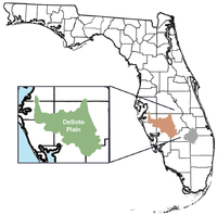
DeSoto Plain

DeSoto Plain
Depiction of the DeSoto Plain.

The DeSoto Plain is a major geologic feature of Florida formed during the Miocene epoch and named for DeSoto County, Florida, United States.

The DeSoto is an old prairie or grassland at elevations of 70 to 100 feet bounded by the lower elevation Okeechobee Plain on the east. It covers the counties of DeSoto, Manatee, Hardee, Highlands Glades, and Charlotte.[1]

The DeSoto plain was the ancient feature of Florida as the peninsula formed over time. Edward Petuch writes that the DeSoto plain had rivers which poured sediments into the Polk Subsea during the Miocene's Serravallian and early Langhian stages filling the Okeechobean Basin to the south.[2] A large complex river delta was formed between the time of the Polk Subsea and the creation of the Charlotte Subsea called the DeSoto Delta. This delta continued to carry sediments from a paleovalley on the DeSoto Plain and Lake Wales Ridge system region to the basin's western side. (Petuch, p. 50)

See also

References

  1. ^ State of Florida, Department of Natural Resources, open file report 85, Geology of Sarasota County.
  2. ^ Petuch, Edward J., Roberts, Charles. The geology of the Everglades and adjacent areas. (page 57) CRC Press, 2007. ISBN 142004558X.

Wikimedia Foundation. 2010.

Игры ⚽ Нужно решить контрольную?

Look at other dictionaries:

  • DeSoto County, Mississippi — DeSoto County courthouse in Hernando DeSoto County, Mississippi …   Wikipedia

  • Okeechobee Plain — Depiction of location of Okeechobee Plain according to the FL EPA The Okeechobee Plain is a major geologic feature of Florida formed during the Pliocene and Pleistocene epochs and named for Okeechobee County, Florida, United States. Contents …   Wikipedia

  • Mississippi Alluvial Plain —   Mississippi Delta …   Wikipedia

  • Okeechobean Sea — Table displaying the Okeechobean Sea and its relation to geologic time and North American Land Mammal Ages. Dry periods or marine regressive periods are tan in color. The Okeechobean Sea was a Cenozoic eutropical subsea, which along with the… …   Wikipedia

  • Mabila — Also see: Mauvilla. The town of Mabila[1](or Mavila, Mavilla, Mauvilla)[2] was a small fortress town known to Chief Tuskaloosa in 1540, in a region of present day central Alabama.[1] The exact location has been debated for centuries. Mabila was a …   Wikipedia

  • Memphis metropolitan area — Memphis, TN MS AR Metropolitan Statistical Area Common name: The Mid South Largest city Memphis, Tennessee …   Wikipedia

  • Olive Branch, Mississippi —   City   …   Wikipedia

  • Memphis, Mississippi —   Village   Locati …   Wikipedia

  • Nesbit, Mississippi —   Unincorporated community   …   Wikipedia

  • Memphis, Tennessee — [1] ities in the Memphis metropolitan area|Memphis metropolitan area}} Memphis redirects here. For the ancient Egyptian capital, see Memphis, Egypt. For other uses, see Memphis (disambiguation). Memphis   City   …   Wikipedia

Share the article and excerpts

Direct link
Do a right-click on the link above
and select “Copy Link”