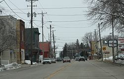
- Dale (CDP), Wisconsin
-
Dale — Census-designated place — Downtown Dale Coordinates: 44°16′23″N 88°40′42″W / 44.27306°N 88.67833°WCoordinates: 44°16′23″N 88°40′42″W / 44.27306°N 88.67833°W Country United States State Wisconsin County Outagamie Area - Total 1.492 sq mi (3.9 km2) - Land 1.492 sq mi (3.9 km2) - Water 0 sq mi (0 km2) Elevation[1] 814 ft (248 m) Population (2010) - Total 528 - Density 353.9/sq mi (136.6/km2) Time zone Central (CST) (UTC-6) - Summer (DST) CDT (UTC-5) ZIP Codes 54931 FIPS code Class Code U6[1] GNIS feature ID 1563669[1] Dale is an unincorporated census-designated place in the town of Dale in Outagamie County, Wisconsin, United States. It is located at the intersection of Wisconsin Highway 96 and County T.[2] As of the 2010 census, its population was 528.[3]
-
Town hall for the town of Dale
References
- ^ a b c "Dale, Wisconsin". Wisconsin Hometown Locator. http://wisconsin.hometownlocator.com/wi/outagamie/dale.cfm. Retrieved 20 April 2010.
- ^ "Location of Dale". Mapquest. http://www.mapquest.com/maps?city=Dale&state=WI. Retrieved 20 April 2010.
- ^ "American FactFinder". U.S. Census Bureau. http://factfinder2.census.gov/main.html. Retrieved 30 March 2011.
Municipalities and communities of Outagamie County, Wisconsin County seat: Appleton Cities Appleton‡ | Kaukauna | New London‡ | Seymour
Villages Bear Creek | Black Creek | Combined Locks | Hortonville | Howard‡ | Kimberly | Little Chute | Nichols | Shiocton | Wrightstown‡
Towns Black Creek | Bovina | Buchanan | Center | Cicero | Dale | Deer Creek | Ellington | Freedom | Grand Chute | Greenville | Hortonia | Kaukauna | Liberty | Maine | Maple Creek | Oneida | Osborn | Seymour | Vandenbroek
CDP Dale
Unincorporated
communitiesApple Creek | Binghamton | Center Valley | Chicago Corners | Darboy‡ | Five Corners | Freedom | Greenville | Hamples Corner | Isaar | Leeman | Mackville | Medina | Murphy Corner | Oneida | Stephensville | Sugar Bush | Twelve Corners
Indian Reservation Ghost towns Grand Chute | Lawesburg | Lime Rock | Wakefield
Categories:- Populated places in Outagamie County, Wisconsin
- Census-designated places in Wisconsin
- Wisconsin geography stubs
Wikimedia Foundation. 2010.


