- Kangding
-
This article is about the metropolitan area of Kangding County. For the administrative division, see Kangding County.
Kangding
康定
དར་མདོ་
Darzêdo
Dardo
Tachienlu · Tatsienlu— Sub-provincial city — Chinese transcription(s) – Characters 康定 – Pinyin Kāngdìng Tibetan transcription(s) – Tibetan script དར་མདོ་ – Wylie dar-rtse-mdo – Tibetan pinyin Darzêdo View of Kangding City Location in Sichuan
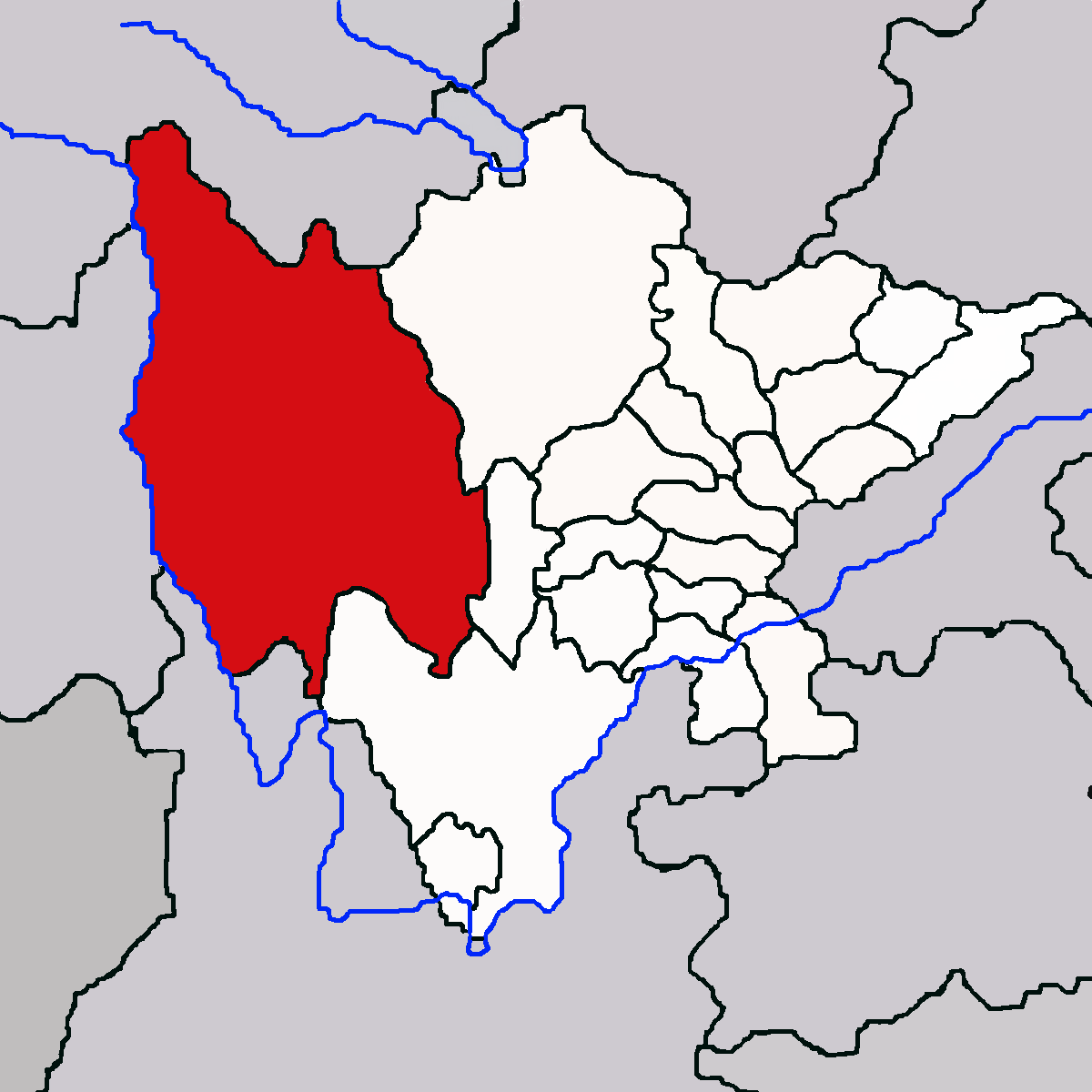
 Kangding
Coordinates: 30°03′19″N 101°57′53″E / 30.05528°N 101.96472°ECoordinates: 30°03′19″N 101°57′53″E / 30.05528°N 101.96472°E County People's Republic of China Province Sichuan Prefecture Garzê Government – CPC Party Chief – Mayor Elevation 2,560 m (8,399 ft) Population – Major Nationalities Han
TibetanTime zone China Standard (UTC+8) Postal code 610000 Website http://www.kangding.gov.cn Kangding or Darzêdo is a city and the location of the seat of Garzê Tibetan Autonomous Prefecture in western Sichuan province of Southwest China. The area that the city occupies is administratively part of Kangding County, and it has around 100,000 inhabitants.
Contents
Names
Kangding (Chinese: 康定; pinyin: Kāngdìng; Wade–Giles: K'ang-ting) is also known as Darzêdo (Tibetan: དར་རྩེ་མདོ།, Wylie: dar-rtse-mdo, ZYPY: Darzêdo) or Dardo (Tibetan: དར་མདོ།, Wylie: dar mdo, ZYPY: Dardo). Historically, the town was known as Tachienlu or Tatsienlu (traditional Chinese: 打箭爐; simplified Chinese: 打箭炉; pinyin: Dǎjiànlú) from the Chinese transliteration of the Tibetan name Dartsedo.
History
Kangding was for many centuries an important trading town where Chinese brick tea was carried by porters from Chengdu and other centres to trade for Tibetan wool.[1]
On July 1, 1786 an earthquake of 7.4 on the Richter magnitude scale ruined nearly the entire city.[citation needed]
- "Tachienlu is surely sui generis; there can be no other town quite like it. Situated eight thousand four hundred feet above the sea, it seems to lie at the bottom of a well, the surrounding snow-capped mountains towering perhaps fifteen thousand feet in the air above the little town which, small as it is, has hardly room to stand, while outside the wall there is scarcely a foot of level ground. It is wedged into the angle where three valleys come together, the Tar and the Chen rivers meeting just below the town to form the Tarchendo, and our first view of the place as we turned the cliff corner that here bars the gorge, was very striking, grey walls and curly roofs standing out sharply from the flanking hillsides."[2]
During time of the Republic of China administration, Kangding was the capital of the now-defunct province of Xikang.
Description
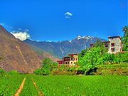
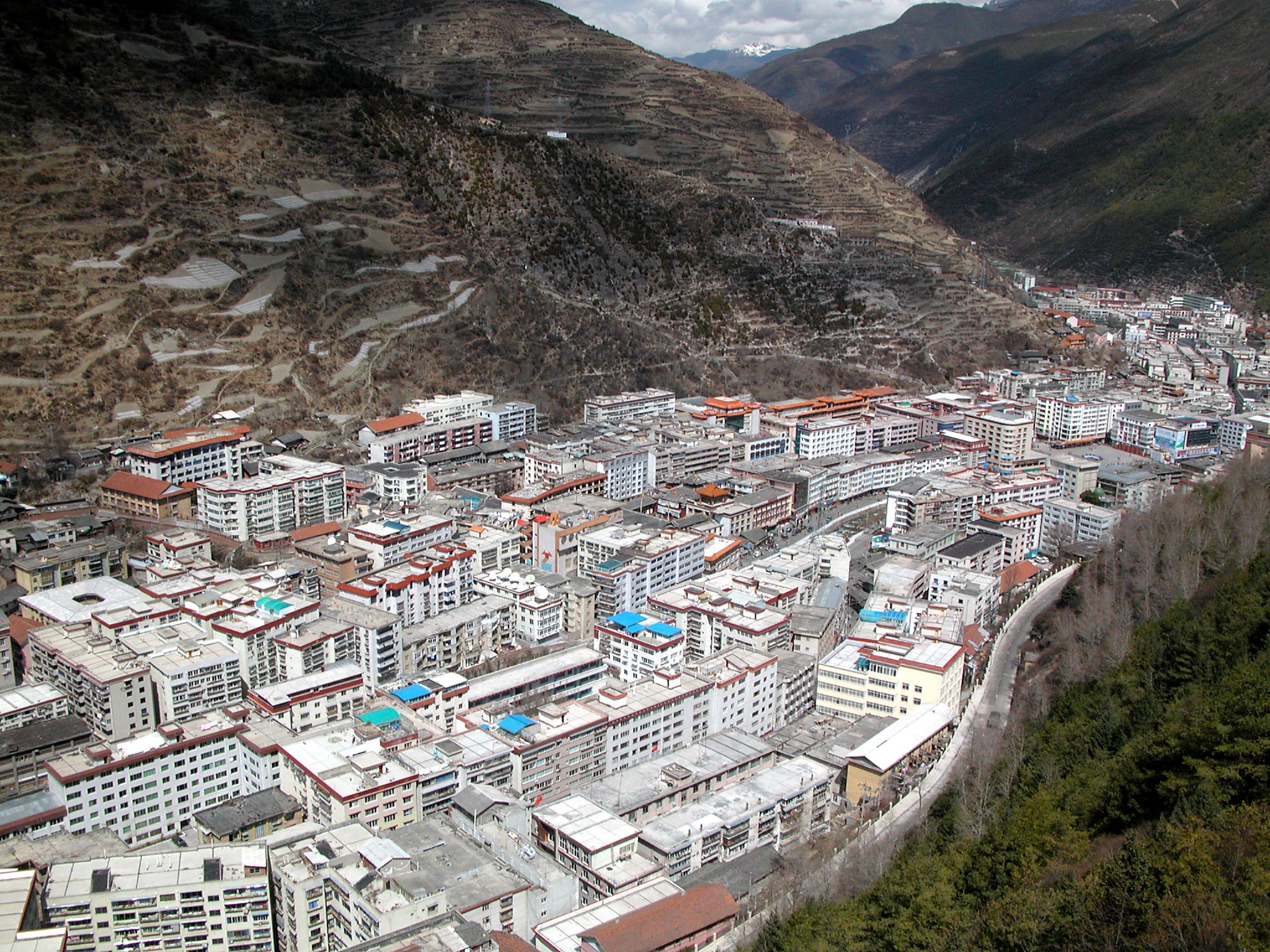
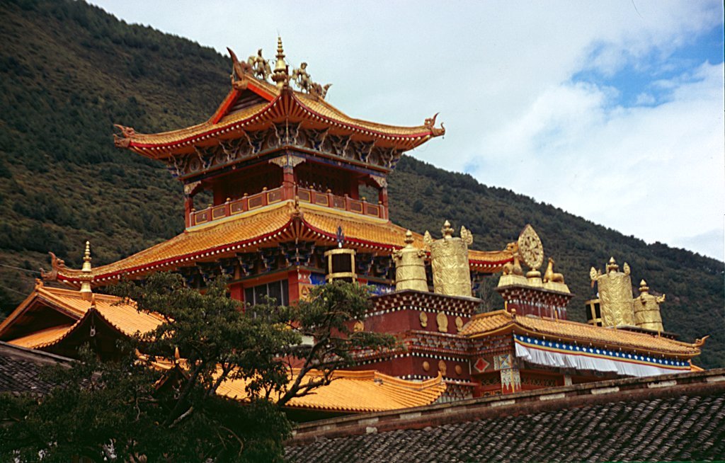
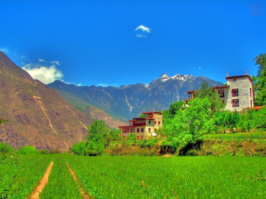
Kangding is located in a valley of the Tibetan Plateau about 210 kilometres (130 mi) west-southwest of Chengdu, the provincial capital, and 100 kilometres (62 mi) west of Ya'an. It is a city populated by significant proportions of both Tibetans and Han, and is part of the historical Tibetan region of Kham. A raging river splits the city, thus the constant sound of water emanates throughout much of the city. The city features a sizable city square where young and old alike gather in the early hours of the morning to do Tai Chi, play badminton, or socialise. This square comes alive on the weekends as well, when families tend to populate it. Traditional Tibetan and Sichuanese restaurants are easily found throughout the city. A Tibetan Buddhist monastery sits on the mountains overlooking the city, and is accessible by cable car. As of October 2006, a stone amphitheatre is under construction at the upper monastery.
It is a fast growing city, with a rapidly developing tourist infrastructure, including a scenic cable car imported from Germany.
In 2008 the PRC government opened an airport at Kangding in the province of Sichuan, with a 4,000 metres (13,000 ft) runway, announcing that it would be the second-highest in the world, at 4,280 metres (14,040 ft) above sea level.[3][4]
The folk song Kangding Qingge enjoys popularity throughout China.
Kangding contains some Buddhist monasteries of note, including Nanwu Si Monastery, Anque Monastery and Jinggang Monastery.
Climate
Kangding has a monsoon-influenced climate, lying in the transition between a humid continental (Dwb) and a subtropical highland climate (Cwb) on the Köppen system. Despite the elevation of 2,560 metres (8,400 ft), nighttime temperatures average at most 10.5 °C (18.9 °F) cooler than daytime highs. From April to September, rain is a very common occurrence, with around two-thirds of the days receiving some rainfall; in addition, 77% of the annual precipitation is delivered from May to September. Monthly daily average temperatures range from −2.2 °C (28.0 °F) in January to 15.5 °C (59.9 °F) in July; the annual mean is 7.09 °C (44.8 °F). Over the course of the year, there are 177 frost-free days and 1738 hours of sunshine.
Climate data for Kangding Month Jan Feb Mar Apr May Jun Jul Aug Sep Oct Nov Dec Year Record high °C (°F) 22.2
(72.0)23.2
(73.8)26.0
(78.8)26.8
(80.2)29.4
(84.9)26.5
(79.7)26.7
(80.1)27.5
(81.5)25.5
(77.9)23.5
(74.3)20.5
(68.9)17.7
(63.9)29.4
(84.9)Average high °C (°F) 3.5
(38.3)5.1
(41.2)9.5
(49.1)13.8
(56.8)16.3
(61.3)17.9
(64.2)20.2
(68.4)20.4
(68.7)16.3
(61.3)12.2
(54.0)8.6
(47.5)5.1
(41.2)12.4 Average low °C (°F) −5.9
(21.4)−4.3
(24.3)−0.8
(30.6)3.3
(37.9)6.9
(44.4)9.9
(49.8)12.0
(53.6)11.8
(53.2)8.8
(47.8)4.6
(40.3)−0.2
(31.6)−4.3
(24.3)3.5 Record low °C (°F) −13.3
(8.1)−13.8
(7.2)−11.2
(11.8)−3.8
(25.2)−1.3
(29.7)0.6
(33.1)2.7
(36.9)1.0
(33.8)0.1
(32.2)−3.2
(26.2)−8.3
(17.1)−14.1
(6.6)−14.1
(6.6)Precipitation mm (inches) 5.5
(0.217)11.6
(0.457)33.3
(1.311)57.3
(2.256)107.4
(4.228)169.4
(6.669)123.2
(4.85)103.9
(4.091)135.0
(5.315)63.7
(2.508)16.5
(0.65)5.4
(0.213)832.2
(32.764)Avg. precipitation days (≥ 0.1 mm) 6.5 9.8 12.5 17.4 20.4 23.1 21.8 19.7 20.1 14.8 7.7 5.2 179.0 Source: Weather China Administration
Administratively, the city of Kangding is not an official township-level division within the Kangding County,[5], but rather the metropolitan area of the county, consisting of the town of Lucheng and several other villages.
Transport
References
Notes
- ^ Leffman, et al (2005), p. 946.
- ^ Kendall (1913), pp. 122-123.
- ^ Aviation Week & Space Technology Vol 169 No 17, "Second-Highest Airport", p. 26
- ^ "World's second highest airport opens in SW China" Kamaid. Oct. 22, 2008
- ^ "2009年康定县行政区划" (in Simplified Chinese). xzqh.org. http://www.xzqh.org/html/2010/1215/21786.html. Retrieved 2011-04-22.
Bibliography
- Dorje, Gyurme (1999). Footprint Tibet Handbook with Bhutan. 2nd Edition. Footprint Handbooks, Bath, England. ISBN 1 900949 33 4.
- Kendall, Elizabeth (1913). A Wayfarer in China: Impressions of a trip across West China and Mongolia. The Riverside Press, Cambridge. Boston and New York.
- Leffman, David, et al. (2005). The Rough Guide to China. 4th Edition. Rough Guides, New York, London, Delhi. ISBN 978-1-84353-479-2.
Garzê Tibetan Autonomous Prefecture, Sichuan County-level divisions Kangding County · Danba County · Luhuo County · Jiulong County · Garzê County · Yajiang County · Xinlong County · Dawu County · Baiyü County · Litang County · Dêgê County · Xiangcheng County · Sêrxü County · Daocheng County · Sêrtar County · Batang County · Luding County · Dêrong County

Towns and villages Kangding (Lucheng) · Batang Town · Zhaggo · Xindu · Garba · Garzê · Hekou · Rulong · Jianshe · Dêgê · Axu Town · Goinqên · Litang Town · Xambala · Nyongxar · Jinzhu · Sêrkog · Luqiao · Lengqi · Xinglong · Moxi · Lan'an · Pengba · Tianba · Chuni · Jiajun · Dewei · Xinxing · Detuo · Sangmai · Bumser · Dzagyel · Junyung · Jowo · Kabshi · Kyangma · Pathul · Kyewu · Sershul Town · Tseboum Soumdo · Tsemkhog · Wombo · Serxu · Danba
Geography Mount Gongga · Dadu River
Landmarks Derge Parkhang · Dzogchen Monastery · Dzongsar Monastery · Gongchen Monastery · Kanze Monastery · Nanwu Monastery · Sershul Monastery · Tongkor Monastery · Luding BridgeCategories:- Populated places in the Garzê Tibetan Autonomous Prefecture

Wikimedia Foundation. 2010.