- Litang Town
Infobox Settlement
name =Litang Town
official_name =
other_name =
native_name =
nickname =
settlement_type =Town
total_type =
motto =
translit_lang1= Tibetan
translit_lang1_type=Tibetan
translit_lang1_info= ལི་ཐང།
translit_lang1_type1=Wylie
translit_lang1_info1=li thang
translit_lang1_type2=
translit_lang1_info2=
translit_lang1_type3=
translit_lang1_info3=
translit_lang2=Chinese
translit_lang2_type=Chinese
translit_lang2_info=高城镇
translit_lang2_type1=Pinyin
translit_lang2_info1=Gāochéng Zhèn
translit_lang2_type2=
translit_lang2_info2=
translit_lang2_type3=
translit_lang2_info3=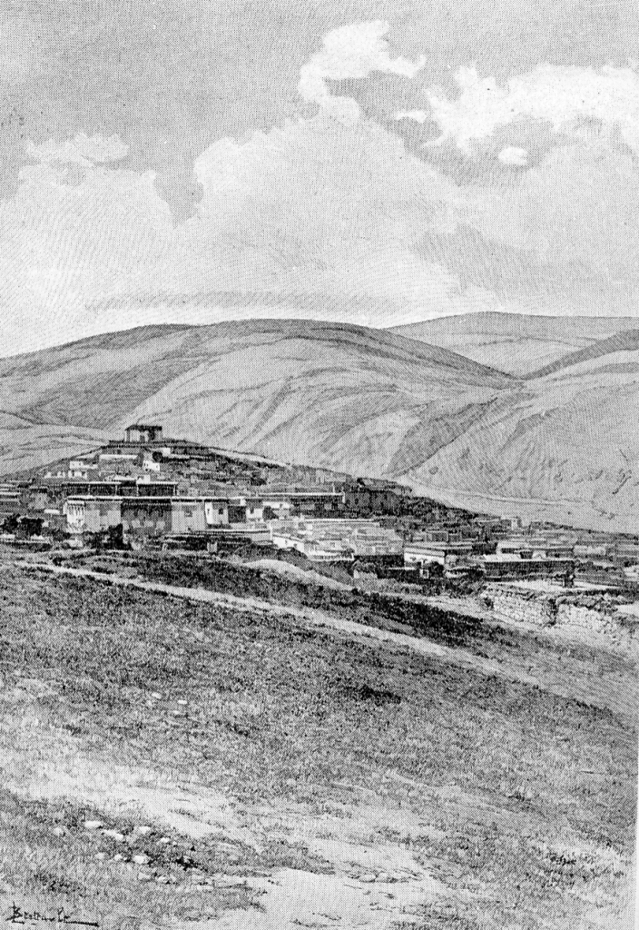
imagesize = 220px
image_caption =Litang Town in the 1840s
flag_size =
image_
seal_size =
image_shield =
shield_size =
image_blank_emblem =
blank_emblem_type =
blank_emblem_size =
mapsize =
map_caption =
mapsize1 =
map_caption1 =
image_dot_
dot_mapsize =
dot_map_caption =
dot_x = |dot_y =
pushpin_
pushpin_label_position =
pushpin_map_caption =
pushpin_mapsize =
subdivision_type = Country
subdivision_name = China
subdivision_type1 = Province
subdivision_name1 =Sichuan
subdivision_type2 = Prefecture
subdivision_name2 = Garzê
subdivision_type3 = County
subdivision_name3 =Litang County
seat_type =
seat =
parts_type =
parts_style =
parts =
p1 =
p2 =
government_footnotes =
government_type =
leader_title =
leader_name =
leader_title1 =
leader_name1 =
leader_title2 =
leader_name2 =
leader_title3 =
leader_name3 =
leader_title4 =
leader_name4 =
established_title =
established_date =
established_title1 =
established_date1 =
established_title2 =
established_date2 =
established_title3 =
established_date3 =
founder =
named_for =
area_magnitude =
unit_pref =
area_footnotes =
area_total_km2 =
area_land_km2 =
area_water_km2 =
area_total_dunam =
area_total_sq_mi =
area_land_sq_mi =
area_water_sq_mi =
area_water_percent =
area_urban_km2 =
area_urban_sq_mi =
area_metro_km2 =
area_metro_sq_mi =
area_blank1_title =
area_blank1_km2 =
area_blank1_sq_mi =
elevation_footnotes =
elevation_m =
elevation_ft =
elevation_max_m =
elevation_max_ft =
elevation_min_m =
elevation_min_ft =
population_as_of =2001
population_footnotes =
population_note =
population_total =47500
population_density_km2 =
population_density_sq_mi =
population_metro =
population_density_metro_km2 =
population_density_metro_sq_mi =
population_urban =
population_density_urban_km2 =
population_density_urban_sq_mi =
population_blank1_title =
population_blank1 =
population_density_blank1_km2 =
population_density_blank1_sq_mi =
timezone = China Standard
utc_offset = +8
timezone_DST =
utc_offset_DST =
coor_type =
latd= |latm= |lats= |latNS=
longd= |longm= |longs= |longEW=
postal_code_type =
postal_code =
area_code =
blank_name =
blank_info =
blank1_name =
blank1_info =
blank2_name =
blank2_info =
blank3_name =
blank3_info =
blank4_name =
blank4_info =
blank5_name =
blank5_info =
blank6_name =
blank6_info =
website =
footnotes =Litang Town (also Lithang, bo|t=ལི་ཐང།|w=li-thang; Chinese: 高城镇; [ [http://www.xzqh.org/quhua/51sc/3334lt.htm Information on Litang County] ]
Pinyin : Gāochéng Zhèn) is the administrative centre ofLitang County in the southwest of theGarzê Tibetan Autonomous Prefecture inSichuan Province of China.The county in 2001 had a population of 47,500. Several famous Buddhist figures were born here, including the
Kelzang Gyatso , the 7th Dalai Lama,Tsultrim Gyatso , the 10th Dalai Lama, four of thePabala s, and has strong connections with the epic heroGesar of Ling , [Mayhew, Bradley and Kohn, Michael. (2005). "Tibet". 6th Edition, p. 257. Lonely Planet. ISBN 1-74059-523-8.] as well as the 5thJamyang Xaiba ofLabrang .Litang Town is located at an altitude of 4,014 metres (13,169 ft) among open grasslands and surrounded by snow-capped mountains. Its actual altitude is about 400 metres higher thanLhasa , making it one of the highest towns in the world [Buckley, Michael and Straus, Robert. (1986) "Tibet: a travel survival kit", p, 219. Lonely Planet Publications. South Yarra, Victoria, Australia. ISBN 0-908086-88-1.] [Mayhew, Bradley and Kohn, Michael. (2005). "Tibet". 6th Edition, p. 257. Lonely Planet. ISBN 1-74059-523-8.] . The town itself is centred just to the south of the Ganden Thubchen Choekhorling or Litang Chöde Monastery.The monastery was built by
Sonam Gyatso (1543 – 1588), the 3rd Dalai Lama in 1580 after the king of Lithang, who ruled the region as defacto independent ruler, switched allegiance from theKagyupa to theGelugpa , while they were still warring with each other. [Laird, Thomas (2006). "The Story of Tibet: Conversations with the Dalai Lama", p. 146. Grove Press, N.Y. ISBN 978-0-8021-827-1.]During the 1950s the region around Litang was one of the main areas of Tibetan armed resistance to the Chinese occupation. A resistance group called "Four Rivers, Six Ranges" was active in the area. In 1956 the monastery was bombed by the
Chinese People's Liberation Army .There are hot springs just 4 km from the centre of town on the western outskirts. [Mayhew, Bradley and Kohn, Michael. (2005). "Tibet". 6th Edition, p. 260. Lonely Planet. ISBN 1-74059-523-8.]
In August, 2007, a horse-racing festival at Litang was the scene of an impromptu anti-government political speech by
Runggye Adak , which was followed by protests calling for his release including 200 people who went to the police station but were allowed to leave unharmed. ["Tibetans, Chinese Police in Sichuan Festival Standoff." Radio Free Asia 2007.08.02 [http://www.rfa.org/english/tibetan/2007/08/02/tibetan_protest/] ] A crackdown officially described as "patriotic education campaign" followed in autumn of 2007, including several politically motivated arrests and attempts to force local Tibetans to denounce the Dalai Lama. ["Crackdown in eastern Tibet." [http://phayul.com/news/tools/print.aspx?id=18161&t=0] ]Footnotes
Further reading
* Tsering Shakya: "The Dragon in the Land of Snows. A History of Modern Tibet Since 1947", London 1999, ISBN 0-14-019615-3
Wikimedia Foundation. 2010.