- Transfăgărășan
-
DN7C
Drumul Național 7C
Transfăgărășan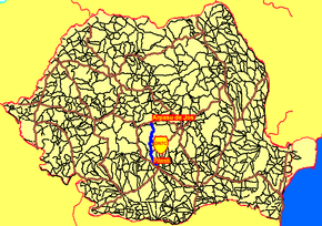
Route information Maintained by Compania Națională de Autostrăzi și Drumuri Naționale din România Length: 90 km (60 mi) Existed: 1974 – present Major junctions From: Pitești To: Arpașu de Jos Location Major cities: Căpățâneni, Bâlea Lake, Arpașu de Jos, Arefu, Pitești, Curtea de Argeș Highway system Coordinates: 45°35′25.14″N 24°37′42.35″E / 45.5903167°N 24.6284306°E
The Transfăgărășan (trans (over, across) + Făgăraș) or DN7C, also known as Ceaușescu's Folly is the second-highest paved road in Romania, and considered by some to be the most dramatic. Built as a strategic military route, the 90 km of twists and turns run north to south across the tallest sections of the Southern Carpathians, between the highest peak in the country, Moldoveanu, and the second highest, Negoiu. The road connects the historic regions of Transylvania and Wallachia, and the cities of Sibiu and Pitești.
Contents
History
The road was constructed between 1970 and 1974, during the rule of Nicolae Ceaușescu. It came as a response to the 1968 invasion of Czechoslovakia by the Soviet Union. Ceaușescu wanted to ensure quick military access across the mountains in the event the Soviets attempted a similar move into Romania. Consequently, the road was built mainly with military forces, at a high cost both financially and from a human standpoint—roughly 6 million kilograms of dynamite were used on the northern face, and the official records mention that about 40 soldiers lost their lives in building accidents.
Route
 Panoramic view (from Bâlea Lake to Avrig)
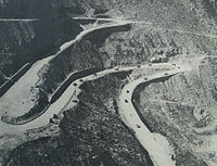 Transfăgărășan in 1974.
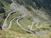 Same section of the road as above in 2007.
The road climbs to 2,034 metres altitude. The most spectacular route is from the North. It is a winding road, dotted with steep hairpin turns, long S-curves, and sharp descents. The Transfăgărășan is both an attraction and a challenge for hikers, cyclists, drivers and motorcycle enthusiasts alike. Due to the topography, the average speed is around 40 km/h. The road also provides access to Bâlea Lake and Bâlea Waterfall.
The road is usually closed from late October until late June because of snow. Depending on the weather, it may remain open until as late as November. It may also be closed, at times, because of weather conditions (it occasionally snows even in August). There are signs at the town of Curtea de Argeș and the village of Cartisoara that provide information on the passage. Travellers can find food and lodging at several hotels or chalets (cabane) along the way.
It has more tunnels (a total of 5)[1] and viaducts than any other road in Romania. Near the highest point, at Bâlea Lake, the road passes through Bâlea Tunnel, the longest road tunnel in Romania (884 m).
Among the attractions along the southern section of the road, near the village of Arefu, is the Poienari fortress. The castle served as the residence of Vlad III the Impaler, the prince who inspired Bram Stoker’s Dracula character. There is a parking area and a path to the ruins.
The northern section is used as a part of yearly cyclist competitions Tour of Romania (Romanian: Turul României). The difficulty of this section is considered to be very similar to Hors Categorie climbs (literally beyond categorization) in the Tour de France.
Cultural references
- In September 2009 the cast and crew of the British television show Top Gear were seen filming along the road.[2] The segment appeared in first episode of Series 14 which first aired November 15, 2009. They were in the country on a grand tour with an Aston Martin DBS Volante, Ferrari California and a Lamborghini Gallardo LP560-4 Spyder. Jeremy Clarkson, the Top Gear host, had said about Transfăgărășan that "this is the best road... in the world". Previously this title was given to Stelvio Pass.
See also
- Transalpina
- List of highest paved roads in Europe
- List of mountain passes
- Stelvio Pass
- Trollstigen
- Tourism in Romania
References
External links
- Transfagarasan Romania collection photo gallery,maps,road direction,oppening,Lake Balea,Vidraru
- Virtual Tour – Amazing Transfagarasan road
- Virtual Tour – Transfagarasan Mountain
- Virtual Tour – Transfarasan waterfalls – amazing landscape
- Article about the Transfagarasan road
- Transfăgărășan Photos
- Pictures and images from Fagaras Mountains, including Transfagarasan National Road
- Transfăgărășan Photo Gallery
- MotoRomania – Transfăgărășan Photo Gallery and Road Description
- Transfagarasan Pictures
- Night-time pictures on the Transfagarasan
- The Transfagarasan in winter
 Main Roads in Romania
Motorways Autostrada Bucureşti-Piteşti (A1) · Autostrada Soarelui (A2) · Autostrada Transilvania (A3) · Autostrada Litoral (A4) · Autostrada Moldova (A5) · Autostrada Est-Vest (A6)
Main national roads Other national roads Categories:- Roads in Romania
- Sibiu County
- Argeș County
- Mountain passes of Romania


Wikimedia Foundation. 2010.