DN10

DN10

RO Roadsign 10.svg

DN10
Drumul Naţional 10
Route information
Maintained by Compania Naţională de Autostrăzi şi Drumuri Naţionale din România
Length: 146.3 km (90.9 mi)
Major junctions
From: Buzău
To: Braşov
Location
Counties: Buzău, Covasna, Braşov
Major cities: Buzău, Braşov
Highway system

Roads in Romania

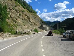
DN10 near Lake Siriu, the area of the December 2006 landslide. Photo taken in July 2007

The DN10 is a Romanian national road, that runs from Buzău to Braşov, crossing the Carpathian Mountains through the Buzău Pass.

The road follows the Buzău River valley and is an important connection between Transylvania and the cities of the south-eastern Romania.

The December 2006 landslide

On 16 December 2006, a massive landslide which occurred in the Siriu commune near kilometer 81 has rendered DN10 unusable in that area, as some 5000 m³ of dirt have flooded the road. The road was cleared and became available again by 22 December, a week after the landslide occurred.[1]

References


Wikimedia Foundation. 2010.

Игры ⚽ Поможем решить контрольную работу

Look at other dictionaries:

  • Roads in Romania — Romania s Road Network Transport in Romania Roads Automobiles Railways Metro Civil Aviation …   Wikipedia

  • Bawtry — infobox UK place country = England official name= Bawtry latitude= 53.4278 longitude= 1.0167 map type= South Yorkshire population = metropolitan borough= Doncaster metropolitan county= South Yorkshire CountyType= Metropolitan county region=… …   Wikipedia

  • Buzău — Infobox Settlement subdivision type = Country subdivision name = ROU timezone = EET utc offset = +2 timezone DST = EEST utc offset DST = +3 map caption = Location of Buzău image caption = The Communal Palace in Dacia Square, Buzău official name …   Wikipedia

  • Scrooby — infobox UK place country = England official name= Scrooby latitude= 53.4101 longitude= 1.0207 scale= 20000 map type= Nottinghamshire population = shire district= Bassetlaw shire county = Nottinghamshire region= East Midlands constituency… …   Wikipedia

  • Austerfield — infobox UK place country = England latitude= 53.44 longitude= 1.00 map type= South Yorkshire official name= Austerfield population = metropolitan borough= Doncaster region= Yorkshire and the Humber metropolitan county = South Yorkshire post town …   Wikipedia

  • List of postcode districts in the United Kingdom — This is a list of postcode districts in the United Kingdom. A group of postcode districts with the same alphabetical prefix is called a postcode area. All, or part, of one or more postcode districts are grouped into post towns.[1] Contents 1 List …   Wikipedia

  • DN1 — Drumul Naţional 1 Route information …   Wikipedia

  • DN2 — Drumul Naţional 2 Route information …   Wikipedia

  • DN3 — Drumul Naţional 3 Route information Maintained by Compania Naţională de Autostrăzi şi Drumuri Naţionale din România …   Wikipedia

  • DN1B — The DN1B is a national road (drum naţional in Romanian) which runs from Ploieşti to Buzău via Mizil. The DN1B has recently been upgraded. On its first segment, from Ploieşti to Valea Călugărească it runs through one of Romania s most important… …   Wikipedia

Share the article and excerpts

Direct link
Do a right-click on the link above
and select “Copy Link”