- D48 road (Croatia)
-
D48 state road
Route information Length: 19.1 km (11.9 mi) Major junctions From:  D21 and
 D302 near Baderna
 D64 just outside Pazin
To:  A8 in Rogovići interchange
Location Counties: Istria Major cities: Pazin Highway system State roads in Croatia
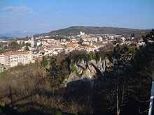 Pazin, at the eastern terminus of D48
D48 is a state road connecting the city of Pazin with D21 and D302 state roads near Baderna, the latter serving as a connecting road to A9/B9 expressway.[1]
The D48 road thus serves as a connection between the two arms of Istrian Y and towns in the centre of Istria peninsula, including Pazin, Baderna and Žminj. The road is 19.1 km (11.9 mi) long.[2]
The road, as well as all other state roads in Croatia, is managed and maintained by Hrvatske ceste, a state-owned company.[3]
Contents
Traffic volume
Traffic is regularly counted and reported by Hrvatske ceste, operator of the road.[4] Substantial variations between annual (AADT) and summer (ASDT) traffic volumes are attributed to the fact that the road connects two arms of Istrian Y carrying substantial tourist traffic.
D48 traffic volume Road Counting site AADT ASDT Notes  D48
D482712 Tinjan 3,235 5,088 The only published traffic counting site on D48. Road junctions and populated areas
D48 major junctions/populated areas Type Slip roads/Notes  A8 motorway in Rogovići interchange to Kanfanar, Pula, Rovinj and Poreč (to the west) and Rijeka (to the east).
Ž5190 to Žminj and Svetvinčenat.
Eastbound D48 traffic defaults to Ž5190.
The eastern terminus of the road.
L50190 to Pazin. D64 to Pazin.Ž5007 to Karojba and Oprtalj. 
Tinjan
Ž5075 to Sveti Petar u Šumi.Jakovići D21 to Buje and Pula.
D302 to A9/B9 expressway in Baderna interchange and to Poreč.
Westbound D48 traffic defaults to D302.
The western terminus of the road.Sources
- ^ "Interchanges of the Y" (in English). May 15, 2010. http://www.bina-istra.com/Default.aspx?sid=1180.
- ^ "Decision on categorization of public roads as state roads, county roads and local roads" (in Croatian). Narodne novine. February 17, 2010. http://narodne-novine.nn.hr/clanci/sluzbeni/2010_02_17_410.html.
- ^ "Public Roads Act" (in Croatian). Narodne novine. December 14, 2004. http://narodne-novine.nn.hr/clanci/sluzbeni/2004_12_180_3130.html.
- ^ "Traffic counting on the roadways of Croatia in 2009 - digest" (in English). Hrvatske ceste. May 1, 2010. http://www.hrvatske-ceste.hr/WEB%20-%20Legislativa/brojenje-prometa/CroDig2009.pdf.
External links
Categories:- State roads in Croatia
- Istria County


Wikimedia Foundation. 2010.