- Crutchfield Crossroads, North Carolina
-
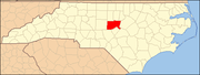
Crutchfield Crossroads, North Carolina — Unincorporated community — Location of Crutchfield Crossroads in North Carolina

Coordinates: 35°48′31″N 79°25′57″W / 35.80861°N 79.4325°W Country United States State North Carolina County Chatham Elevation[1] 627 ft (191 m) Time zone Eastern (EST) (UTC-5) – Summer (DST) EST (UTC-4) ZIP code FIPS code GNIS feature ID 985012[1] Crutchfield Crossroads is an unincorporated community in northwestern Chatham County, North Carolina north of the town of Siler City. Crutchfield Crossroads is commonly defined as the area in and around the rural intersection of Silk Hope-Liberty Road. and Siler City- Snow Camp Road. At the intersection of the two roads, there are some stores, but other than that the entire community is agricultural. Children living in this area attend schools in Silk Hope and Siler City.
References
- ^ a b U.S. Geological Survey Geographic Names Information System: Crutchfield Crossroads, North Carolina. Retrieved on 22 October 2008.
Municipalities and communities of Chatham County, North Carolina Towns Cary‡ | Goldston | Pittsboro | Siler City
CDP Unincorporated
communitiesBear Creek | Bells | Bennett | Bonlee | Brickhaven | Bynum | Carbonton | Corinth | Crutchfield Crossroads | Farrington | Gulf | Harpers Crossroads | Haywood | Lockville | Moncure | Seaforth | Silk Hope | Wilsonville
Footnotes ‡This populated place also has portions in an adjacent county or counties
Coordinates: 35°48′31″N 79°25′57″W / 35.80861°N 79.4325°W
Some of North Carolina's oldest farms are located near this intersection.
Categories:- Populated places in Chatham County, North Carolina
- Unincorporated communities in North Carolina
- North Carolina geography stubs


Wikimedia Foundation. 2010.