Forbes County

Forbes County
Forbes
New South Wales
Forbes NSW.PNG
Location in New South Wales
Lands administrative divisions around Forbes
Cunningham Ashburnham Bathurst
Gipps Forbes Bathurst
Bland Monteagle King

Forbes County is one of the 141 Cadastral divisions of New South Wales.

Forbes County was named in honour of Chief Justice Sir Francis Forbes (1784-1841).[1] It is located south of the Lachlan River near Forbes, down to Grenfell. It includes the area along the Lachlan east to Cowra and the Boorowa River, and also south to Koorawatha

The Lachlan River at Cowra; the river is the boundary between Forbes and Bathurst

Parishes within this county

A full list of parishes found within this county; their current LGA and mapping coordinates to the approximate centre of each location is as follows:

Parish LGA Coordinates
Bandon Forbes Shire 33°31′54″S 148°15′04″E / 33.53167°S 148.25111°E / -33.53167; 148.25111 (Bandon)
Bang Bang Cowra Shire 34°01′54″S 148°38′04″E / 34.03167°S 148.63444°E / -34.03167; 148.63444 (Bang Bang)
Binda Weddin Shire 33°38′54″S 148°23′04″E / 33.64833°S 148.38444°E / -33.64833; 148.38444 (Binda)
Birangan Weddin Shire 33°42′54″S 148°07′04″E / 33.715°S 148.11778°E / -33.715; 148.11778 (Birangan)
Bogolong Weddin Shire 33°48′54″S 148°05′04″E / 33.815°S 148.08444°E / -33.815; 148.08444 (Bogolong)
Boyd Forbes Shire 33°54′54″S 147°36′04″E / 33.915°S 147.60111°E / -33.915; 147.60111 (Boyd)
Braulin Forbes Shire 33°30′54″S 148°01′04″E / 33.515°S 148.01778°E / -33.515; 148.01778 (Braulin)
Broula Cowra Shire 33°50′54″S 148°33′04″E / 33.84833°S 148.55111°E / -33.84833; 148.55111 (Broula)
Bundaburrah Forbes Shire 33°30′54″S 147°53′04″E / 33.515°S 147.88444°E / -33.515; 147.88444 (Bundaburrah)
Conimbla Cowra Shire 33°46′54″S 148°31′04″E / 33.78167°S 148.51778°E / -33.78167; 148.51778 (Conimbla)
Cudgelong Cowra Shire 33°54′54″S 148°46′04″E / 33.915°S 148.76778°E / -33.915; 148.76778 (Cudgelong)
Cumbijowa Forbes Shire 33°25′54″S 148°08′04″E / 33.43167°S 148.13444°E / -33.43167; 148.13444 (Cumbijowa)
Currowong Forbes Shire 33°40′54″S 147°50′04″E / 33.68167°S 147.83444°E / -33.68167; 147.83444 (Currowong)
Erasa Forbes Shire 33°15′54″S 148°12′04″E / 33.265°S 148.20111°E / -33.265; 148.20111 (Erasa)
Eualdrie Weddin Shire 33°53′54″S 148°03′04″E / 33.89833°S 148.05111°E / -33.89833; 148.05111 (Eualdrie)
Gooloogong Cowra Shire 33°39′54″S 148°31′04″E / 33.665°S 148.51778°E / -33.665; 148.51778 (Gooloogong)
Goonigal Forbes Shire 33°37′54″S 148°17′04″E / 33.63167°S 148.28444°E / -33.63167; 148.28444 (Goonigal)
Jemalong Forbes Shire 33°26′54″S 147°48′04″E / 33.44833°S 147.80111°E / -33.44833; 147.80111 (Jemalong)
Kangarooby Weddin Shire 33°42′54″S 148°20′04″E / 33.715°S 148.33444°E / -33.715; 148.33444 (Kangarooby)
Maudry Forbes Shire 33°41′54″S 148°03′04″E / 33.69833°S 148.05111°E / -33.69833; 148.05111 (Maudry)
Melyra Weddin Shire 33°48′54″S 148°11′04″E / 33.815°S 148.18444°E / -33.815; 148.18444 (Melyra)
Merriganowry Cowra Shire 33°44′54″S 148°32′04″E / 33.74833°S 148.53444°E / -33.74833; 148.53444 (Merriganowry)
Morongla Cowra Shire 33°53′54″S 148°39′04″E / 33.89833°S 148.65111°E / -33.89833; 148.65111 (Morongla)
Mulyan Cowra Shire 33°48′54″S 148°35′04″E / 33.815°S 148.58444°E / -33.815; 148.58444 (Mulyan)
Mulyandry Forbes Shire 33°31′54″S 148°07′04″E / 33.53167°S 148.11778°E / -33.53167; 148.11778 (Mulyandry)
Nanima Forbes Shire 33°31′54″S 148°20′04″E / 33.53167°S 148.33444°E / -33.53167; 148.33444 (Nanima)
Neila Cowra Shire 34°01′54″S 148°43′04″E / 34.03167°S 148.71778°E / -34.03167; 148.71778 (Neila)
Ooma Forbes Shire 33°38′54″S 148°09′04″E / 33.64833°S 148.15111°E / -33.64833; 148.15111 (Ooma)
Tallabung Forbes Shire 33°33′54″S 147°49′04″E / 33.565°S 147.81778°E / -33.565; 147.81778 (Tallabung)
Thurungle Forbes Shire 33°35′54″S 148°02′04″E / 33.59833°S 148.03444°E / -33.59833; 148.03444 (Thurungle)
Waayourigong Forbes Shire 33°25′54″S 147°54′04″E / 33.43167°S 147.90111°E / -33.43167; 147.90111 (Waayourigong)
Wallah Wallah Weddin Shire 33°44′54″S 148°15′04″E / 33.74833°S 148.25111°E / -33.74833; 148.25111 (Wallah Wallah)
Warraderry Weddin Shire 33°41′54″S 148°13′04″E / 33.69833°S 148.21778°E / -33.69833; 148.21778 (Warraderry)
Warrangong Cowra Shire 33°59′54″S 148°30′04″E / 33.99833°S 148.50111°E / -33.99833; 148.50111 (Warrangong)
Warrumba Cowra Shire 33°48′54″S 148°22′04″E / 33.815°S 148.36778°E / -33.815; 148.36778 (Warrumba)
Wattamondara Cowra Shire 33°54′54″S 148°37′04″E / 33.915°S 148.61778°E / -33.915; 148.61778 (Wattamondara)
Wheoga Weddin Shire 33°45′54″S 147°56′04″E / 33.765°S 147.93444°E / -33.765; 147.93444 (Wheoga)
Wongajong Forbes Shire 33°25′54″S 148°02′04″E / 33.43167°S 148.03444°E / -33.43167; 148.03444 (Wongajong)

References


Wikimedia Foundation. 2010.

Игры ⚽ Нужно сделать НИР?

Look at other dictionaries:

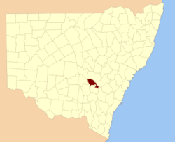
  • Forbes County, New South Wales — Infobox Australian cadastral name = Forbes state = New South Wales caption = Location in New South Wales near nw = Cunningham near n = Ashburnham near ne = Bathurst near e = Bathurst near se = King near s = Monteagle near sw = Bland near w =… …   Wikipedia

  • Forbes Creek — (39.041°N, 122.912°W) [ [http://www.topozone.com/states/California.asp?county=Lake California Topo Maps] ] is a watercourse in Lake County, California [gnis|223663|Forbes Creek] which empties into Clear Lake at the city of Lakeport.In 1989, a… …   Wikipedia

  • Forbes Avenue — is one of the longest streets in Pittsburgh, Pennsylvania, United States. It has a length of about ten miles (16 km) and is named for General John Forbes (1707 ndash;1759), whose expedition recaptured Fort Duquesne and who renamed the place… …   Wikipedia

  • Forbes, Minnesota — Forbes is a community in St. Louis County, Minnesota, USA.The community is located southwest of the city of Eveleth at the junction of County Highway 7 and County Highway 16Forbes is located on the boundary line of Clinton Township and McDavitt… …   Wikipedia

  • Forbes, Missouri — Forbes is an unincorporated community in southeastern Holt County, Missouri, United States. It is located about five miles southeast of Oregon. Its post office has closed and mail now comes from Oregon …   Wikipedia

  • Forbes Baronets — There have been five Baronetcies created for people with the surname Forbes, four in the Baronetage of Nova Scotia and one in the Baronetage of the United Kingdom. The first holder of the Burn Baronetcy of Jessfield, created in the Baronetage of… …   Wikipedia

  • County roads in St. Louis County, Minnesota — Contents 1 CR 1–CR 20 2 CR 21–CR 40 3 CR 41–CR 60 4 …   Wikipedia

  • Forbes Field (airport) — Infobox Airport name = Forbes Field IATA = FOE ICAO = KFOE FAA = FOE type = Public owner = Metropolitan Topeka Airport Authority operator = city served = Topeka, Kansas location = elevation f = 1,078 elevation m = 329 website = r1 number = 13/31… …   Wikipedia

  • Forbes Road School District — Infobox School name = Forbes Road School District location = Fulton County, Pennsylvania country = USA coordinates = coord|40|05|04|N|78|03|52|W|region:US type:edu|display=inline schoolboard = superintendent = faculty = 41.0 (on FTE basis) ratio …   Wikipedia

  • County of Bourke, Victoria — Bourke Victoria Location in Victoria Lands administrative divisions around Bourke …   Wikipedia

Share the article and excerpts

Direct link
Do a right-click on the link above
and select “Copy Link”