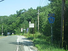
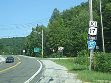
- County Route 72 (Rockland County, New York)
-
County Route 72 Sterling Mine Road Route information Length: 1.6 mi[1] (2.6 km) Existed: by 1991 – present Major junctions West end: Orange County line at Sloatsburg (becomes CR 72) East end:  NY 17 in Sloatsburg
Highway system Numbered highways in New York
Interstate • U.S. • N.Y. (former) • Reference • County (Rockland)County Route 72 (CR 72) is a 1.6-mile (2.6 km) west–east county-maintained highway in the western part of Rockland County, New York, in the United States. CR 72 begins at the Orange County line in Sloatsburg and Eagle Valley, and ends at NY 17 (NY 17). It runs exclusively through Sloatsburg, and is the only Rockland County Route to intersect NY 17. After the western terminus, CR 72 continues as Orange County Route 72 until reaching the New Jersey border. It is the only road in Rockland County that eventually leads into Passaic County, New Jersey. After crossing the New Jersey border, Sloatsburg Road proceeds south through Ringwood Manor State Park before ending at Passaic CR 511.
CR 72 is one of two county routes that are shared by Rockland and Orange County. The other is County Route 106. The total length combined for Orange CR 72 and Rockland CR is 3.4 miles (1.8 in Orange and 1.6 in Rockland).
Contents
Route description
Rockland County Route 72 begins at the Orange county line in Eagle Valley. The road, now known as Sterling Mine Road, enters Rockland briefly before turning back into Orange County for a short distance. It returns to Rockland County and intersects with CR 68 at 0.1 miles (0.2 km). CR 86 now parallels Route 72 as it heads into Sloatsburg. The main highway heads to north for a short distance before turning to the south. Route 72 enters the community of Sterlington and terminates at an interchange with NY 17 just south of downtown Sloatsburg.[1]
History
County Route 72 mainly resides in Sloatsburg, New York. Sloatsburg dates back to the Indian name of Pothat, being renamed after the Sloat family, who had come to the country in 1639 from Denmark. The Sloat family eventually settled in America in 1754. Along nearby NY 17, the Sloat family's house still stands.[2]
Around 1982, the Rockland County Highway Department had a different system of highways around the county. The most southern north–south highways in Rockland County were designated with low numbers, such as 1, 2, 3 or 4. County Route 72, being the westernmost county-maintained highway, was designated as County Route 1.[3] When Rockland County renumbered their highway system, County Route 1, was renumbered to match up with Orange County Route 72 at the Orange/Rockland County border.[4]
Major intersections
The entire route is in Rockland County.
Location Mile Destinations Notes Tuxedo Park 0.0  CR 72 (Sterling Mine Road)
Continuation into Orange County Sloatsburg 0.1  CR 68 (Eagle Valley Road)
1.6  NY 17
NY 171.000 mi = 1.609 km; 1.000 km = 0.621 mi See also
References
- ^ a b Google Maps. Overview Map of Rockland CR 72 (Map). http://maps.google.com/maps?f=d&hl=en&geocode=13596664313227422547,41.156217,-74.216316%3B12238121508401493797,41.148931,-74.195116&saddr=CR-72%2FSterling+Mine+Rd+%4041.156310,+-74.216160&daddr=41.147961,-74.190567&mrcr=0&mrsp=1&sz=16&mra=dme&sll=41.150482,-74.192455&sspn=0.007562,0.014591&ie=UTF8&ll=41.150482,-74.19239&spn=0.060493,0.11673&z=13&om=1. Retrieved September 23, 2007.
- ^ Zimmermann, Linda (2004). Rockland County Scrapbook. Eagle Press. pp. 122. ISBN 9780971232648. http://books.google.com/books?id=cs5oAO4IXXsC. Retrieved January 3, 2009.
- ^ Rand McNally Inc. (1982). Business Traveler's Road Atlas (Map). Cartography by Rand McNally Inc..
- ^ New York State Department of Transportation (1991). Westchester & Rockland county map (Map). Cartography by New York State Department of Transportation.
External links
Categories:- County routes in Rockland County, New York
Wikimedia Foundation. 2010.


