- Coppull Mill, Chorley
-
Coordinates: 53°37′38″N 2°39′41″W / 53.6271°N -2.6615°E
Coppull 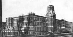
 Shown within Lancashire
Cotton Spinning (ring mill) Location Coppull, Chorley Further ownership Lancashire Cotton Corporation (1930s) Courtaulds (1964) Coordinates 53°37′38″N 2°39′41″W / 53.6271°N -2.6615°E Power Date 1906 Construction Firm J & E Wood Engine Type triple expansion four cylinder engine Valve Gear Corliss valves rpm 68rpm Diameter of Flywheel 26ft Type of transmission rope No, of Ropes. 36 Boiler configuration Pressure 200psi References [1] Coppull Mill, Chorley is a cotton spinning mill in Coppull, Chorley, Lancashire. It was built in 1906 and it sister mill, Mavis Mill opened in 1908, together they employed 700 workers. It was taken over by the Lancashire Cotton Corporation in the 1930s and passed to Courtaulds in 1964.
Contents
Location
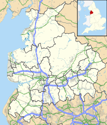
Coppull is a village and civil parish in Lancashire, England. It is part of the borough of Chorley, lies around 300 feet (91 m) above sea level and has a population of around 7,600. It is bounded by Whittle Brook, Clancutt Brook, the River Yarrow, Eller Brook, Hic-Bibi Brook and Stars Brook. Coppull is located between Chorley and Wigan, to the east of the A49 road near Charnock Richard. The village was 6 km from the Leeds and Liverpool Canal but was served from 1834 by the North Union Railway.
History
Coppull expanded greatly along with the rest of Lancashire during the Industrial Revolution of the 18th century. As well as the Cotton industry the town is situated on the Lancashire Coalfield. There were several major collieries located in the town during this era with notable collieries being Chisnall Hall and Ellerbeck. Coppull Mill, Chorley was built in 1906, with elaborate decoration. It was used to spin 10's to 24's counts for general manufacture.
The industry peaked in 1912 when it produced 8 billion yards of cloth. The Great War of 1914–18 halted the supply of raw cotton, and the British government encouraged its colonys to build mills to spin and weave cotton. The war over, Lancashire never regained its markets. The independent mills were struggling. The Bank of England set up the Lancashire Cotton Corporation in 1929 to attempt to rationalise and save the industry.[2] Coppull Mill, Chorley was one of 104 mills bought by the LCC, and one of the 53 mills that survived through to 1950.
Architecture
A four storey late mill, with terracotta decoration. It had an elaborately decorated water tower. An extension for carding was to the west, it had a separate boiler house and circular chimney.[3][4]
Power
It was driven by a-1600 hp triple expansion four cylinder engine by J & E Wood built in 1906. Its 26 ft flywheel operated at 68rpm and ran 36 ropes. It steamed at 200psi. [5]
Equipment
Ring frames doing coarse counts.
Later extensions
Usage
Owners
- Lancashire Cotton Corporation (1930's-1964)
- Courtaulds (1964-
Tenants
Notable events/media
See also
Lancashire cotton Architects 
Engine makers Daniel Adamson · Ashton Frost · Ashworth & Parker · Bateman & Sherratt · Boulton & Watt · Browett & Lindley · Buckley & Taylor · Carel · Earnshaw & Holt · Goodfellow · Fairbairn · W & J Galloway & Sons · B Goodfellow · Hick, Hargreaves & Co · Benjamin Hick and Sons · John Musgrave & Sons · J & W McNaught · Petrie of Rochdale · George Saxon · Scott & Hodgson · Urmson & Thompson · Yates of Blackburn · Yates & Thom · Whilans · J & E Wood · Woolstenhulmes & RyeMachinery makers Brooks & Doxey · Butterworth & Dickinson · Curtis, Parr & Walton · Dobson & Barlow · John Hetherington & Sons · Joseph Hibbert · Howard & Bullough · Geo. Hattersley · Asa Lees · Mather & Platt · Parr, Curtis & Madely · Platt Brothers · Taylor, Lang & Co · Textile Machinery Makers Ltd · Tweedales & Smalley- Oldham Limiteds · Fine Spinners and Doublers · Lancashire Cotton Corporation · Courtaulds · Bagley & WrightIndustrial processes Textile manufacturing · Cotton-spinning machinery · Friction Spinning · Magnetic ring spinning · Open end spinning · Ring spinning · Spinning frame · Spinning jenny · Spinning mule · Water frame · Roberts Loom · Lancashire LoomLists of mills LCC mills · Bolton · Bury · Cheshire · Derbyshire · Lancashire · Manchester · Oldham · Rochdale · Salford · Stockport · Tameside · WiganMuseums Bury Pilot Mill, Bury · Wilton Mill, Radcliffe
Bolton Lancashire Manchester and Salford Oldham Ace Mill, Hollinwood · Blackridings Mill, Oldham · Dawn Mill, Shaw · Fox Mill, Hollinwood · Hawk Mill, Shaw · Heron Mill, Hollinwood · Junction Mill, Middleton Junction · Kent Mill, Chadderton · Laurel Mill, Middleton Junction · Magnet Mill, Chadderton · Majestic Mill, Waterhead · Manor Mill, Chadderton · Newby Mill, Shaw · Orme Mill, Waterhead · Regent Mill, Failsworth · Royd Mill, Oldham · Royton Ring Mill, Royton · Rutland Mill, Shaw · Textile Mill, Chadderton · Trent Mill, ShawRochdale Stockport Elder Mill, Romiley · Kingston Mill, Stockport · Palmer Mills, Stockport · Vernon Mill, Stockport · Welkin Mill, Lower BredburyTameside Atlas Mill, Ashton-under-Lyne · Cedar Mill, Ashton-under-Lyne · Rock Mill, Ashton-under-Lyne · Saxon Mill, Droylsden · Stalybridge Mill, Stalybridge · Texas Mill, Ashton-under-Lyne · Tudor Mill, Ashton-under-Lyne · Waterside Mill, Ashton-under-LyneWigan West Yorkshire Foxsons Mill, Staincliffe · Mons Mill, TodmordenReferences
- ^ LCC 1951
- ^ Dunkerley
- ^ Ashmore 1982, p. 199
- ^ LCC 1951, p. 18
- ^ Roberts 1921
Notes
Bibliography
- Ashmore, Owen (1982). The industrial archaeology of North-west England. Manchester University Press. ISBN 0719008204. http://books.google.co.uk/books?id=pXa7AAAAIAAJ&pg=PA212&lpg=PA212&dq=room+and+power+mills&source=bl&ots=BEQsI2NGfL&sig=ZJP7OYVvFZbOQUA7x7J7FtNagtw&hl=en&ei=M0hPSve3I4O6jAfxubioCQ&sa=X&oi=book_result&ct=result&resnum=11. Retrieved 2009-06-25.
- Dunkerley, Philip (2009). "Dunkerley-Tuson Family Website, The Regent Cotton Mill, Failsworth". http://dunkerley-tuson.co.uk/regentmill.aspx. Retrieved 2009-01-09.
- LCC (1951). The mills and organisation of the Lancashire Cotton Corporation Limited. Blackfriars House, Manchester: Lancashire Cotton Corporation Limited.
- Roberts, A S (1921), "Arthur Robert's Engine List", Arthur Roberts Black Book. (One guy from Barlick-Book Transcription), http://oneguyfrombarlick.co.uk/forum_topic.asp?TOPIC_ID=7926&FORUM_ID=99&CAT_ID=3&Forum_Title=Rare+Text+(Book+Transcriptions)&Topic_Title=ARTHUR+ROBERTS+ENGINE+LIST&whichpage=1&tmp=1#pid81483, retrieved 2009-01-11
External links
Categories:- Textile mills owned by the Lancashire Cotton Corporation
- Textile mills in Lancashire
- Buildings and structures in Chorley


Wikimedia Foundation. 2010.