- Century Mill, Farnworth
-
Coordinates: 53°32′43″N 2°24′40″W / 53.5454°N -2.4112°E
Century 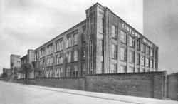
 Shown within Greater Manchester
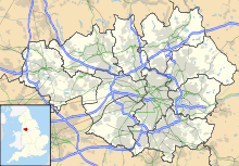
Cotton Spinning (ring mill) Location George St, Dixon Green. Further ownership Lancashire Cotton Corporation (1930s) Courtaulds (1964) Coordinates 53°32′43″N 2°24′40″W / 53.5454°N -2.4112°E Power Date 1902 Construction Firm Hick Hargraves Engine Type cross compound Valve Gear Corliss rpm 59 Diameter of Flywheel 27ft No, of Ropes. 45 Boiler configuration Pressure 190 References [1] [2] Century Mill, Farnworth is a cotton spinning mill in Farnworth, Bolton, Greater Manchester. It was built in the early 20th century, for ring spinning. It was taken over by the Lancashire Cotton Corporation in the 1930s and passed to Courtaulds in 1964. It was still standing with its chimney in 2004.
Contents
Location
Farnworth is a town within the Metropolitan Borough of Bolton in Greater Manchester, England.[3] It is located 3.3 miles (5.3 km) southeast of Bolton and 9 miles (14.5 km) northwest of Manchester. It has no canal but the Manchester, Bolton and Bury Canal passed close by. It is served by a station on the Lancashire and Yorkshire Railway.
Historically a part of Lancashire, Farnworth lies on the River Irwell and the River Croal, and according to the United Kingdom Census 2001 it has a population of 25,264 people.[4]
History
Century mill was built early in the 20th century, spinning 40's counts on ring frames for general-purpose work.
The industry peaked in 1912 when it produced 8 billion yards of cloth. The Great War of 1914–1918 halted the supply of raw cotton, and the British government encouraged its colonys to build mills to spin and weave cotton. The war over, Lancashire never regained its markets. The independent mills were struggling. The Bank of England set up the Lancashire Cotton Corporation in 1929 to attempt to rationalise and save the industry.[5] Century Mill, Farnworth was one of 104 mills bought by the LCC, and one of the 53 mills that survived through to 1950. In 2004 it was standing and still had its chimney.
Architecture
Power
It had a 1500 hp cross compound engine by Hick, Hargreaves & Co built in 1902 steamed at 190psi. The cylinders were 26"HP , 54"LP on a 5 ft stroke. The 27 ft flywheel drove 45 ropes at 59rpm.[6]
Equipment
Rings
Owners
- Lancashire Cotton Corporation (1930s–1964)
- Courtaulds (1964–
See also
Lancashire cotton Architects 
Engine makers Daniel Adamson · Ashton Frost · Ashworth & Parker · Bateman & Sherratt · Boulton & Watt · Browett & Lindley · Buckley & Taylor · Carel · Earnshaw & Holt · Goodfellow · Fairbairn · W & J Galloway & Sons · B Goodfellow · Hick, Hargreaves & Co · Benjamin Hick and Sons · John Musgrave & Sons · J & W McNaught · Petrie of Rochdale · George Saxon · Scott & Hodgson · Urmson & Thompson · Yates of Blackburn · Yates & Thom · Whilans · J & E Wood · Woolstenhulmes & RyeMachinery makers Brooks & Doxey · Butterworth & Dickinson · Curtis, Parr & Walton · Dobson & Barlow · John Hetherington & Sons · Joseph Hibbert · Howard & Bullough · Geo. Hattersley · Asa Lees · Mather & Platt · Parr, Curtis & Madely · Platt Brothers · Taylor, Lang & Co · Textile Machinery Makers Ltd · Tweedales & Smalley- Oldham Limiteds · Fine Spinners and Doublers · Lancashire Cotton Corporation · Courtaulds · Bagley & WrightIndustrial processes Textile manufacturing · Cotton-spinning machinery · Friction Spinning · Magnetic ring spinning · Open end spinning · Ring spinning · Spinning frame · Spinning jenny · Spinning mule · Water frame · Roberts Loom · Lancashire LoomLists of mills LCC mills · Bolton · Bury · Cheshire · Derbyshire · Lancashire · Manchester · Oldham · Rochdale · Salford · Stockport · Tameside · WiganMuseums Bury Pilot Mill, Bury · Wilton Mill, Radcliffe
Bolton Ainsworth Mill, Breightmet · Bolton Union Mill, Bolton · Century Mill, FarnworthLancashire Manchester and Salford Oldham Ace Mill, Hollinwood · Blackridings Mill, Oldham · Dawn Mill, Shaw · Fox Mill, Hollinwood · Hawk Mill, Shaw · Heron Mill, Hollinwood · Junction Mill, Middleton Junction · Kent Mill, Chadderton · Laurel Mill, Middleton Junction · Magnet Mill, Chadderton · Majestic Mill, Waterhead · Manor Mill, Chadderton · Newby Mill, Shaw · Orme Mill, Waterhead · Regent Mill, Failsworth · Royd Mill, Oldham · Royton Ring Mill, Royton · Rutland Mill, Shaw · Textile Mill, Chadderton · Trent Mill, ShawRochdale Stockport Elder Mill, Romiley · Kingston Mill, Stockport · Palmer Mills, Stockport · Vernon Mill, Stockport · Welkin Mill, Lower BredburyTameside Atlas Mill, Ashton-under-Lyne · Cedar Mill, Ashton-under-Lyne · Rock Mill, Ashton-under-Lyne · Saxon Mill, Droylsden · Stalybridge Mill, Stalybridge · Texas Mill, Ashton-under-Lyne · Tudor Mill, Ashton-under-Lyne · Waterside Mill, Ashton-under-LyneWigan West Yorkshire Foxsons Mill, Staincliffe · Mons Mill, TodmordenReferences
Notes
- ^ LCC 1951
- ^ "List of mills in Farnworth". Bolton Council. http://www.bolton.gov.uk/portal/page?_pageid=207,407315&_dad=portal92&_schema=PORTAL92. Retrieved 2009-01-10.
- ^ "Greater Manchester Gazetteer". Greater Manchester County Record Office. Places names - D to F. http://www.gmcro.co.uk/Guides/Gazeteer/gazzd.htm. Retrieved 20 June 2007.
- ^ Census 2001, Key Statistics for urban areas England and Wales. URL accessed 18 June 2007.
- ^ Dunkerley
- ^ Roberts 1921
Bibliography
- Dunkerley, Philip (2009). "Dunkerley-Tuson Family Website, The Regent Cotton Mill, Failsworth". http://dunkerley-tuson.co.uk/regentmill.aspx. Retrieved 2009-01-09.
- LCC (1951). The mills and organisation of the Lancashire Cotton Corporation Limited. Blackfriars House, Manchester: Lancashire Cotton Corporation Limited.
- Roberts, A S (1921), "Arthur Robert's Engine List", Arthur Roberts Black Book. (One guy from Barlick-Book Transcription), http://oneguyfrombarlick.co.uk/forum_topic.asp?TOPIC_ID=7926&FORUM_ID=99&CAT_ID=3&Forum_Title=Rare+Text+(Book+Transcriptions)&Topic_Title=ARTHUR+ROBERTS+ENGINE+LIST&whichpage=1&tmp=1#pid81483, retrieved 2009-01-11
External links
Categories:- Textile mills owned by the Lancashire Cotton Corporation
- Textile mills in Bolton


Wikimedia Foundation. 2010.