- Clemenceau (Cottonwood)
-
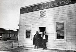
Clemenceau, Arizona The Bank of Clemenceau, founded 1918. The bank building is preserved on the grounds of the Clemenceau Heritage Museum. Coordinates: 34°43′55″N 112°01′36″W / 34.73194°N 112.02667°WCoordinates: 34°43′55″N 112°01′36″W / 34.73194°N 112.02667°W Country United States State Arizona County Yavapai Elevation[1] 3,471 ft (1,058 m) Time zone MST (no DST) (UTC-7) Clemenceau is a neighborhood of the city of Cottonwood in Yavapai County, Arizona, United States. It was built as a company town in 1917 to serve the new smelter for James Douglas, Jr.'s United Verde Extension mine in Jerome. The town was originally named Verde after the mine, but it was changed to Clemenceau in 1920 in honor of the French Premier in World War I, Georges Clemenceau, a personal friend of Mr. Douglas. Clemenceau would later leave a vase designed by the French potter Ernest Chaplet to the town in return.[1]
The Clemenceau smelter closed on December 31, 1936. Most residents then left the area. When Cottonwood was incorporated in 1960, Clemenceau and the Clemenceau Airport were included in its boundaries.
With the exception of the school, the bank/post office and the smelter slag pile, little remains of the original town of Clemenceau. A largely invisible remnant is the Clemenceau Water Company [1], which still serves the area of the old town of Clemenceau. The town of Cottonwood bought the company in 2004, but it still operates as a separate entity, as of 2006.
Contents
Clemenceau Heritage Museum
The Clemenceau Heritage Museum occupies most of the old Clemenceau School, which operated 1924-1986. The 1919 Clemenceau Bank and Post Office building is also part of the museum. The museum has displays on mining, logging, and railroad development in the Verde Valley, and preserves archives and artifacts from the area. An elaborate working model railroad display depicts the seven railroads that operated in the Upper Verde Valley from 1895-1953.
Douglas and Clemenceau
James Douglas, Jr., bought an apartment in Paris for his friend, Georges Clemenceau, in 1926, for his retirement home. This building later became the Musée Clémenceau. Source: [2]
Notable residents and visitors
Jack Frye's personal airplane, a TWA Lockheed Model 10 Electra with tail number NC18137, was frequently based at the Clemenceau Airport.[2] Frye had a vacation ranch near Sedona, now Red Rock State Park.
References
External links
Categories:- Neighborhoods in Arizona
- Miniature railways
- History museums in Arizona
- Museums in Yavapai County, Arizona
- Populated places in Yavapai County, Arizona
- Company towns in Arizona
- History of mining
Wikimedia Foundation. 2010.


