Wanup

Wanup
Wanup
—  Community  —
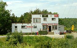
Wanup General Store
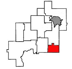
Location of Wanup within Greater Sudbury.
Country Canada Flag of Canada.svg
Province Ontario Flag of Ontario.svg
City Greater Sudbury
Ward 9
Annexed 2001
Government
 – City Councillor Doug Craig
 – Governing Body Greater Sudbury City Council
 – MPs Claude Gravelle (NDP)
 – MPPs France Gélinas (NDP)
Time zone EST (UTC-5)
 – Summer (DST) EDT (UTC-4)
Postal Code FSA P0M
Area code(s) 705

Wanup is a community in the Ontario city of Greater Sudbury. Formerly an unincorporated community in the geographic township of Dill, Wanup was annexed into Greater Sudbury on January 1, 2001 when that city was created by amalgamating the former Regional Municipality of Sudbury.

The community is located along Highway 537, near the interchange with Highway 69. The smaller neighbourhood of St. Cloud, which is treated as part of Wanup for postal delivery and telephone exchange purposes, is located a few kilometres north of Wanup in the former geographic township of Cleland.

History

Settlement of Wanup dates back to the early 1900s, when large numbers of Finns arrived in Canada. Leaving their homeland to escape the political instability of the time and the spectre of war with Russia many Finns chose this area to resume their primarily agricultural lifestyles. This area was popular among the Finns due to the geographical similarities with many parts of Finland. Another important factor was the abundance of available work from the construction of the CN and CP rail lines which pass through the area. Wanup has acted as base for many generations of Finnish Canadians and still retains a high number of Finnish families.

Coordinates: 46°22′59″N 80°49′01″W / 46.383°N 80.817°W / 46.383; -80.817


Wikimedia Foundation. 2010.

Игры ⚽ Нужна курсовая?

Look at other dictionaries:

  • Wanup, Ontario — Infobox Settlement official name = Wanup other name = native name = nickname = settlement type = Community motto = imagesize = image caption = flag size = image seal size = image shield = shield size = city logo = citylogo size = mapsize = map… …   Wikipedia

  • Ontario Highway 537 — Highway 537 Route information Length: 15.4 km[1] (9.6 mi) …   Wikipedia

  • Highway 537 (Ontario) — Infobox road province=ON type=Hwy route=537 marker cities = Greater Sudbury length km=15 length ref= length round=1 established= direction a=South terminus a=jct|state=ON|Hwy|69 at Secord Road in Wanup junction= direction b=North terminus b=Finni …   Wikipedia

  • Lorence G. Collins — Der US amerikanische Petrologe Lorence G. Collins: «Zwei Pfade verzweigten sich im Wald...ich schlug den weniger begangenen ein...das war der Unterschied.» Aus Robert Frost: «The Road Less Taken (Der weniger begangene Weg)» Lorence Gene Larry… …   Deutsch Wikipedia

  • List of communities in Ontario — Communities in the province of Ontario, Canada Note: this is an incomplete list of communities, not necessarily organized municipalities. For organized municipalities see list of municipalities in Ontario and for census subdivisions see list of… …   Wikipedia

  • Greater Sudbury —   City   City of Greater Sudbury Ville de Grand Sudbury From top left: Downtown Sudbury Skyline, Big Ni …   Wikipedia

  • Regional Municipality of Sudbury — Infobox Settlement official name = Regional Municipality of Sudbury other name = native name = nickname = settlement type = regional municipality motto = imagesize = image caption = flag size = image seal size = image shield = shield size = city… …   Wikipedia

  • Provincial highways in Ontario — The Ontario Ministry of Transportation maintains the system of provincial highways in the Canadian province of Ontario. Highway classes Ontario has several distinct classes of highways (French voie publique ): King s Highways, (which includes… …   Wikipedia

  • Walden, Ontario — Walden   Community   Location of Walden within Greater Sudbury. Country Canada …   Wikipedia

  • Greater Sudbury City Council — is the governing body of the City of Greater Sudbury, Ontario, Canada.The council consists of the mayor plus a twelve person council. The city is divided into twelve wards; each ward is represented by one councillor. The council meets at Tom… …   Wikipedia

Share the article and excerpts

Direct link
Do a right-click on the link above
and select “Copy Link”