- Clachanmore
-
Coordinates: 54°46′43″N 4°58′52″W / 54.778549°N 4.981072°W
Clachanmore 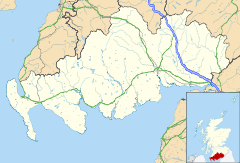
 Clachanmore
Clachanmore shown within Dumfries and GallowayPopulation 20 estimate Council area Dumfries and Galloway Lieutenancy area Wigtown Country Scotland Sovereign state United Kingdom Post town Stranraer Postcode district DG9 Dialling code 01776-860 Police Dumfries and Galloway Fire Dumfries and Galloway Ambulance Scottish EU Parliament Scotland UK Parliament Dumfries and Galloway Scottish Parliament Galloway and Upper Nithsdale List of places: UK • Scotland • Clachanmore is a village in the South Rhins of Galloway near Ardwell in the south west of Scotland. It has also been known as Low Ardwell.[1]
The name of the village means 'great stones' or 'big village' and may derive from a stone circle that formerly stood there;[2] there are remains of a circular enclosure on Barrack Knowe near High Clachanmore farmhouse.[3]
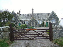 The old schoolhouse at Clachanmore
Clachanmore school is the most prominent building in the village. The building dates to 1831[4] and was the school for Ardwell. There is a small schoolmaster's house next door. Until 2003 it was an art gallery; it is now a private house.
References
- ^ Maria Trotter, ed. Saxon, Galloway Gossip Sixty Years Ago: Being a Series of Articles Illustrative of the Manners, Customs, and Peculiarities of the Aboriginal Picts of Galloway, Choppington, Northumberland: R. Trotter, 1877, OCLC 25797165, pp. 79-80.
- ^ Clachanmore, Royal Commission on the Ancient and Historical Monuments of Scotland.
- ^ Barrack Knowe, High Clachanmore at ScotlandsPlaces.
- ^ Dumfries & Galloway: Summary of places of interest, CAST.
Sources
- Clachanmore at Gazetteer for Scotland
Places in the Rhins of Galloway, Scotland North to SouthKirkcolm • Cairnryan • Leswalt • Stranraer • Castle Kennedy • Lochans • Portpatrick • Stoneykirk • Sandhead • Ardwell • Port Logan • Kirkmaiden • Drummore • Mull of Galloway • ClachanmoreCategories:- Places in the Rhins
- Dumfries and Galloway geography stubs
- Villages in Dumfries and Galloway
- Dumfries and Galloway


Wikimedia Foundation. 2010.