- St Mary's Church, Capel-le-Ferne
-
St Mary's Church, Capel-le-Ferne 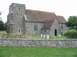
St Mary's Church, Capel-le-Ferne, from the southwestLocation in Kent
 St Mary's Church, Capel-le-Ferne
Coordinates: 51°06′54″N 1°13′25″E / 51.1150°N 1.2235°E OS grid reference TR257400 Location Capel-le-Ferne, Kent Country England Denomination Anglican Website Churches Conservation Trust Architecture Functional status Redundant Heritage designation Grade I Designated 22 August 1962 Architectural type Church Style Norman, Gothic Specifications Materials Flint, tiled roofs 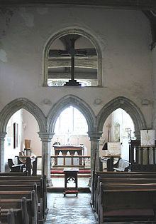 Chancel screen
St Mary's Church, Capel-le-Ferne, is a redundant Anglican church to the northeast of the village of Capel-le-Ferne, Kent, England. It has been designated by English Heritage as a Grade I listed building,[1] and is under the care of the Churches Conservation Trust.[2] The church stands in an isolated position adjacent to Capel Church Farm, to the north of the A20 road and 2 miles (3.2 km) northeast of Folkestone.[2][3]
Contents
History
The church dates from the 12th century. In the following century alterations were made and the tower was added. In the 14th century the chancel screen and porch were built, and most of the windows were added during the 15th century. The church was restored in 1890.[1] It was declared redundant and vested in the Churches Conservation Trust in 1986.[4]
Architecture
Exterior
St Mary's is constructed in flint with tiled roofs. Its plan consists of a nave, a chancel, a south porch, and a west tower. The tower is in two stages, with a west door, angle buttresses, two string courses, and a plain parapet. In the north wall of the nave is a small 12th-century Norman window and the head of a 14th-century window; otherwise all the windows date from the 15th century.[1]
Interior
Inside the church, the nave is divided from the chancel by a 14th-century stone screen. In the lower part of the screen is a three-bay arcade with pointed arches carried on octagonal piers. Between and to the sides of the arches are four corbels which formerly supported the rood screen. Above the arcade the screen is pierced by a large round-headed opening which silhouetted the rood cross.[1] This feature is unique in England.[2] On the east and north walls of the chancel are large moulded corbels. Also in the chancel are an aumbry with a semicircular head, a simple sedilia, and a 13th-century trefoil-headed piscina. The font consists of an octagonal bowl carried on an octagonal stem. In the recess of the Norman north window is painted foliage. There are fragments of medieval stained glass in the east window. The memorials include a brass dated 1526, and a white marble wall plaque to General Sir Charles William Dunbar Staveley who died in 1896.[1]
See also
- List of churches preserved by the Churches Conservation Trust in South East England
References
- ^ a b c d e "Church of St Mary, Capel le Ferne", The National Heritage List for England (English Heritage), 2011, http://list.english-heritage.org.uk/resultsingle.aspx?uid=1070047, retrieved 18 April 2011
- ^ a b c St Mary's Church, Capel-le-Ferne, Kent, Churches Conservation Trust, http://www.visitchurches.org.uk/Ourchurches/Completelistofchurches/St-Marys-Church-CapelleFerne-Kent/, retrieved 29 March 2011
- ^ Capel Church Farm, Streetmap, http://streetmap.co.uk/grid/625585_140079_120, retrieved 29 March 2011
- ^ (PDF) Diocese of Canterbury: All Schemes, Church Commissioners/Statistics, Church of England, 2011, pp. 1–2, http://www.churchofengland.org/media/810388/canterbury%20-%20all%20schemes.pdf, retrieved 29 March 2011
External links
Categories:- Grade I listed buildings in Kent
- Grade I listed churches
- Church of England churches in Kent
- Norman architecture
- English Gothic architecture
- Churches preserved by the Churches Conservation Trust


Wikimedia Foundation. 2010.