- St Garmon's Church, Llanarmon-yn-Iâl
-
St Garmon's Church, Llanarmon-yn-Iâl 
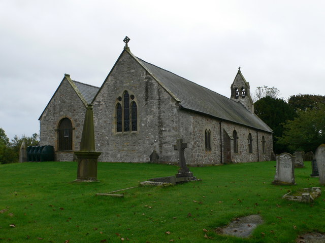
St Garmon's Church, Llanarmon-yn-Iâl,
from the southeastCoordinates: 53°05′47″N 3°12′36″W / 53.0965°N 3.2100°W OS grid reference SJ190561 Location Llanarmon-yn-Iâl, Denbighshire Country Wales Denomination Anglican History Dedication St Garmon Architecture Heritage designation Grade I Designated 19 July 1966 Architect(s) John Douglas Architectural type Church Specifications Materials Stone with a slate roof Administration Parish Llanarmon-yn-Iâl Deanery Dyffryn Clwyd Archdeaconry St Asaph Diocese St Asaph Province Church in Wales Clergy Vicar(s) Rev Huw Butler St Garmon's Church, Llanarmon-yn-Iâl, is in the centre of the village of Llanarmon-yn-Iâl, Denbighshire, Wales. It is an active Anglican church in the diocese of St Asaph, the archdeaconry of St Asaph and the deanery of Dyffryn Clwyd.[1] The church is a Grade I listed building.[2]
Contents
History
The church dates from 1282 and a second nave was added about 1450.[3] Much of the church was rebuilt in 1736 and around this time Edward Whetnall, a carpenter from Wrexham, replaced the stone arcade between the two naves with an arcade in timber. In 1759 a gallery was built at the west end of the south nave, and this was extended in 1781. It is likely that the porch was enlarged in 1774. In 1870 the church was restored by John Douglas, adding some Gothic-style windows and bracing to the colonnade. Also the box pews were removed, and it is likely that the gallery was also removed at this time. There were further restorations in 1906, in the late 1920s, and in the 1970s.[4]
Architecture
Exterior
The church is built in stone, mainly limestone with some sandstone. The roof is of slates with grey ridge tiles. Its plan consists of a double nave. The north nave is wider than the south and at its east end is the chancel. The south nave acts as an aisle, with its east end partitioned to act as a vestry. There is a south porch and a bellcote at the west end over the north nave. The porch has a ball finial and sandstone ridge tiles. The bellcote has apertures for two bells. The division between the north nave and the chancel is marked by a buttress.[4] The medieval arch-braced roofs are still present. Some round-headed windows remain from the 1736 restoration. Other windows are Gothic in style and probably date from Douglas' restoration.[5]
Interior
Inside the church is a baluster font dated 1734 and a pulpit which has been attributed to Douglas. The brass chandelier dates from the 15th or early 16th century and it contains a figure of the Virgin Mary in a canopy. Two of the monuments date from the early 14th century and another is dated 1639. The Royal Arms date from 1740.[5]
External features
The church is in the middle of a churchyard which is almost square with rounded corners overlooking the River Alun. In the churchyard is the shaft of a churchyard cross which was converted into a sundial in 1774.[4]
See also
- List of church restorations, amendments and furniture by John Douglas
References
- ^ Deanery of Dyffryn Clwyd, Church in Wales, http://www.churchinwales.org.uk/asaph/local/deaneries/dyffrynclwyd.html, retrieved 16 June 2009
- ^ Listed Buildings in Wales: Denbighshire, Cadw
- ^ St Garmon, Church in Wales, http://www.churchinwales.org.uk/parishholding/asaph/a035-en/churches-en/st-garmon_-en/church_view, retrieved 16 June 2009
- ^ a b c Church of St Garmon , Llanarmon-yn-Ial, Clwyd-Powys Archaeological Trust, http://www.dyffrynclwyd.org.uk/llanarmon.htm, retrieved 16 June 2009
- ^ a b Hubbard, Edward (1986), Clwyd, The Buildings of Wales, London: Penguin, pp. 186–187, ISBN 0-14-071052-3
Categories:- Churches in Denbighshire
- Anglican churches in Wales
- John Douglas buildings
- Grade I listed churches
- Grade I listed buildings in Denbighshire
Wikimedia Foundation. 2010.