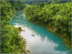
Chixoy River

Chixoy River
Chixoy River
(Río Negro)

Chixoy river in Alta Verapaz (2009)
Origin Guatemala
(Huehuetenango, El Quiché)
Mouth Tributary of the Salinas river
Basin countries Guatemala
Source elevation 2,000 m (6,600 ft)
15°16′13″N 91°24′49″W / 15.27028°N 91.41361°W / 15.27028; -91.41361
Mouth elevation 160 m (520 ft)
16°4′7″N 90°26′28″W / 16.06861°N 90.44111°W / 16.06861; -90.44111
Avg. discharge 551 m3/s (19,500 cu ft/s)
at San Agustín Chixoy
Basin area 1,250 km2 (480 sq mi)[1]

The Chixoy River or Río Negro is a river in Guatemala. The river is called Río Negro from its sources in the highlands of Huehuetenango and El Quiché until it reaches the Chixoy hydroelectric dam (located at 15°16′54″N 90°29′27″W / 15.281536°N 90.490952°W / 15.281536; -90.490952 (Chixoy Hidroelectric Dam)), where the Río Salamá and Rio Carchela converge with the Río Negro. After the Chixoy dam, the river is called Río Chixoy and flows northwards, marking the departmental limits between Alta Verapaz and El Quiché, until it reaches the border with Mexico. From there on it continues along the border for another 113 km as the Salinas river until it finally converges with the Río la Pasión (at 16°28′52″N 90°32′39″W / 16.481193°N 90.544167°W / 16.481193; -90.544167 (Convergence Salinas and Pasión rivers)) to form the Usumacinta river which flows into the Gulf of Mexico.

The Chixoy river's water discharge of 551 m3/s is Guatemala's highest. This was one of the main reasons for selecting this river for the construction of the Chixoy Hydroelectric dam. Guatemala's National Institute for Electricity (INDE) is planning the construction of another hydroelectric dam on the Chixoy river. The proposed location of the Xalalá hydroelectric dam is situated at 15°41′34″N 90°47′11″W / 15.692833°N 90.786361°W / 15.692833; -90.786361 (Planned location Xalalá Hidroelectric Dam).[2] in the municipality of Ixcán, El Quiché.

See also

References

External links


Wikimedia Foundation. 2010.

Игры ⚽ Нужно решить контрольную?

Look at other dictionaries:

  • Chixoy River — ▪ river, Guatemala Spanish  Río Chixoy        river in central Guatemala, rising as the Negro River in the southern part of the Altos (mountains) Cuchumatanes, west of Huehuetenango. First flowing eastward, it forms part of the borders between… …   Universalium

  • Chixoy Hydroelectric Dam — Official name Planta Hidroeléctrica Chixoy Location San Cristóbal Verapaz (Alta Verapaz) Coordinates …   Wikipedia

  • Chixoy — (Río Negro) Chixoy dans l Alta Verapaz (2009) Caractéristiques Longueur  ? Bassin 1 250 km2 …   Wikipédia en Français

  • Chixoy — may refer to: Chixoy River Chixoy Hydroelectric Dam This disambiguation page lists articles associated with the same title. If an internal link led you here, you may wish to change the link to point directly to th …   Wikipedia

  • Chixoy-Polochic Fault — The Chixoy Polochic Fault, also known as Cuilco Chixoy Polochic Fault, is a major fault zone in Guatemala and southwestern Mexico. It runs in a light arc from the east coast of Guatemala to Chiapas, following the deep valleys of the Polochic… …   Wikipedia

  • Chixoy hydroelectric dam — Infobox Dam dam name= Chixoy caption= official name= Hidroeléctrica Chixoy crosses= Río Negro (Río Chixoy) reservoir= locale= San Cristóbal Verapaz (Alta Verapaz) maint= EGEE INDE length= nd m height= 90 m width= began= 1976 open= 1983 closed=… …   Wikipedia

  • Usumacinta River — River, southeastern Mexico and northwestern Guatemala. Rising in western Guatemala, it is formed by the confluence of the Salinas (or Chixoy) and Pasión rivers. It flows northwest and forms a section of the border between Guatemala and Mexico. It …   Universalium

  • Salinas River (Guatemala) — Infobox River river name = Salinas river caption = origin = Guatemala (Huehuetenango, El Quiché) mouth = Tributary of the Usumacinta river basin countries = Guatemala length = 113 km elevation = mouth elevation = discharge = 555.1 m³/s [cite web… …   Wikipedia

  • Usumacinta River — Infobox River river name = Usumacinta River (Río Usumacinta) caption = Usumacinta River, view from Chiapas. The far bank is Guatemala origin = Guatemala coord|15.270358| 91.413717|type:landmark region:GT|display=inline,title|name=Sources… …   Wikipedia

  • Huehuetenango Department — Huehuetenango   Department   Flag …   Wikipedia

Share the article and excerpts

Direct link
Do a right-click on the link above
and select “Copy Link”