- Chelyan, West Virginia
-
Chelyan, West Virginia — Census-designated place — 
 Chelyan, West Virginia
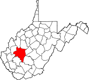
Coordinates: 38°11′43″N 81°29′27″W / 38.19528°N 81.49083°WCoordinates: 38°11′43″N 81°29′27″W / 38.19528°N 81.49083°W Country United States State West Virginia County Kanawha Area[1] – Total 0.430 sq mi (1.1 km2) – Land 0.403 sq mi (1 km2) – Water 0.027 sq mi (0.1 km2) Elevation 617 ft (188 m) Population (2010)[2] – Total 776 – Density 1,804.7/sq mi (696.8/km2) Time zone Eastern (EST) (UTC-5) – Summer (DST) EDT (UTC-4) Area code(s) 304 & 681 GNIS feature ID 1537231[3] Chelyan (pronounced /ˈʃiːl.jən/ sheel-yən) is an unincorporated census-designated place in Kanawha County, West Virginia, United States. Chelyan is located on the south bank of the Kanawha River southeast of Chesapeake. It is served by Exit 85 of the West Virginia Turnpike. As of the 2010 census, its population was 776.[2]
Former NBA player, coach, and general manager Jerry West was born in Chelyan.
References
- ^ "US Gazetteer files: 2010, 2000, and 1990". United States Census Bureau. 2011-02-12. http://www.census.gov/geo/www/gazetteer/gazette.html. Retrieved 2011-04-23.
- ^ a b "American FactFinder". United States Census Bureau. http://factfinder2.census.gov. Retrieved 2011-05-14.
- ^ U.S. Geological Survey Geographic Names Information System: Chelyan, West Virginia
Municipalities and communities of Kanawha County, West Virginia Cities Charleston | Dunbar | Marmet | Montgomery‡ | Nitro‡ | St. Albans | Smithers‡ | South Charleston
Towns Belle | Cedar Grove | Chesapeake | Clendenin | East Bank | Glasgow | Handley | Pratt
CDPs Alum Creek‡ | Big Chimney | Chelyan | Coal Fork | Cross Lanes | Elkview | Jefferson | Pinch | Rand | Shrewsbury | Sissonville | Upper Falls
Other
localitiesAarons | Acme | Acup | Amandaville | Amelia | Annfred | Barren Creek | Blackhawk | Blakeley | Blount | Blue Creek | Blundon | Bream | Brounland | Burnwell | Cabin Creek | Carbon | Cinco | Coalburg | Coalridge | Coco | Corton | Crede | Crown Hill | Davis Creek | Dawes | Decota | Dial | Diamond | Dickinson | Donwood | Dry Branch | Dungriff | Dupont City | East Nitro | East Side | Edgewood | Elk | Elk Forest | Elk Hills | Emmons‡ | Eskdale | Etowah | Falling Rock | Ferrell | Fivemile | Forest Hills | Forks of Coal | Fort Hill | Frame | Gallagher | Giles | Green Valley | Greencastle | Grippe | Guthrie | Hansford | Hernshaw | Hicumbottom | Highlawn | Hillsdale | Hitop | Holly | Hollygrove | Hollyhurst | Hugheston | Institute | Island Branch | Ivydale | Jarrett | Jarretts Ford | Joplin | Kanawha Estates | Kayford | Kelly Hill | Kendalia | Laing | Leewood | London | Lower Falls | Malden | Mammoth | Meadowbrook | Miami | Mink Shoals | Ohley | Pocatalico | Pond Gap | Port Amherst | Quick | River Bend | Riverside | Ruth | Ruthdale | Sharon | Snow Hill | Standard | Tad | Tornado | Victor | Wallace | Whittaker | Winifrede
Footnotes ‡This populated place also has portions in an adjacent county or counties
Categories:- Populated places in Kanawha County, West Virginia
- Census-designated places in West Virginia
- Kanawha County, West Virginia geography stubs


Wikimedia Foundation. 2010.