- Ostend (Frankfurt am Main)
-
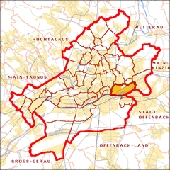
Ostend Stadtteil of Frankfurt Coordinates 50°06′47″N 8°42′2″E / 50.11306°N 8.70056°ECoordinates: 50°06′47″N 8°42′2″E / 50.11306°N 8.70056°E Administration Country Germany State Hesse Admin. region Darmstadt District Urban district Town Frankfurt Basic statistics Area 6.432 km2 (2.483 sq mi) Population 26,547 (31 December 2007) - Density 4,127 /km2 (10,690 /sq mi) Other information Time zone CET/CEST (UTC+1/+2) Licence plate F Postal codes 60314, 60316, 60385 Area code 069 Website www.frankfurt.de Ostend is a borough of Frankfurt am Main, Germany. It is part of the Ortsbezirk Innenstadt IV, and is subdivided into 4 Stadtbezirke. It is home to several brothels located along the Main River. The most famous of these brothels, or "Puffs," is the Eros-Center with its ubiquitous "legs" entrance. Ostend has a spectacular view of Sachsenhausen where many tourists, including young American Soldiers, frivolously spent their money.
The Heinrich-von-Gagern-Gymnasium, a Gymnasium and the Hoch Conservatory are in the Ostend.
Districts of Frankfurt Altstadt · Bahnhofsviertel · Bergen-Enkheim · Berkersheim · Bockenheim · Bonames · Bornheim · Dornbusch · Eckenheim · Eschersheim · Fechenheim · Flughafen · Frankfurter Berg · Gallus · Ginnheim · Griesheim · Gutleutviertel · Harheim · Hausen · Heddernheim · Höchst · Innenstadt · Kalbach-Riedberg · Nied · Nieder-Erlenbach · Nieder-Eschbach · Niederrad · Niederursel · Nordend · Oberrad · Ostend · Praunheim · Preungesheim · Riederwald · Rödelheim · Sachsenhausen · Schwanheim · Seckbach · Sindlingen · Sossenheim · Unterliederbach · Westend · Zeilsheim
 Categories:
- Hesse geography stubs
- Districts of Frankfurt
Wikimedia Foundation. 2010.


